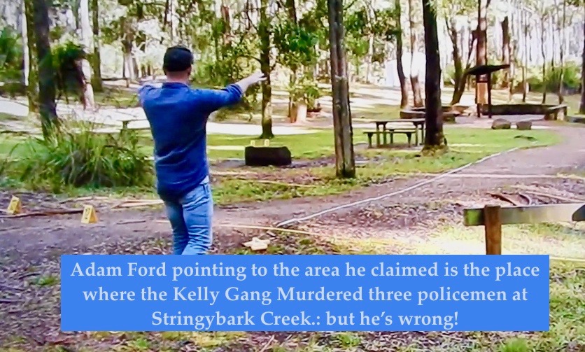
This post is about the claim Adam Ford made on the History Channels Lawless documentary in 2018 that he had located ‘for the first time ever’ the actual site at Stringybark Creek where three police were murdered by the Kelly Gang in 1878.
Last week, in the first part of this two part essay, I described how it was that Ford reached that conclusion. Essentially, what he did was excavate a pile of rocks near the picnic ground at SBC, and declare that because bits of broken pottery and nails and things that he found there were probably of late 19thcentury origin, he had located the ruined hut known to have been at the Police Camp site. He claimed this hut had to be the one at the police campsite because it corresponded with a hut marked on an 1884 map of the area. In the Documentary Ford made it look as if he had discovered this ruined hut after doing a highly sophisticated scan with a drone using a Laser to map the area. He said that he used it to find a flat area of one to two acres, because according to Ford, that was what McIntyre, the surviving police witness had said was where the hut was. In fact, this was a charade, a quite cynical deception designed to impress TV viewers with some whizz-bang kit – amateur historians had shown the pile of rocks to Ford almost the moment he got to SBC but that wouldn’t have created a dramatic TV moment would it? So the Laser gimmick was introduced.
In fact, as Ford himself noted in his Report, nothing was found at this site that specifically linked it to the police campsite – it was a typical hut site of which he said there were many along the creek. The reason he believed that never-the-less this WAS the police campsite, as I explained last week, is because it was on the only area of one to two acres that the drone found in the area that was flat, and because it corresponded with the hut marked on the 1884 map. Last week I finished by writing that both these arguments fail, and now I will show how.
- Ford misinterpreted the Gatward Map
In the Report Adam Ford wrote “In 1884 and reproduced/drafted in 1885 (6 and 7 years after the event) detailed survey maps were made of the area and the location of the ruined hut (mentioned by Kelly and McIntyre) were recorded” (p20)
This is incorrect. The ‘location of the ruined hut’ is not recorded on the Gatward map. What the map records, as shown below, is a hut close to the words ‘Scene of the Police murders by the Kelly Gang’. These words are centred on an area well away from the “HUT”, the hut is not labelled as anything other than a hut, and is certainly not identified as the ‘ruined hut’ seen in the Burman photographs.
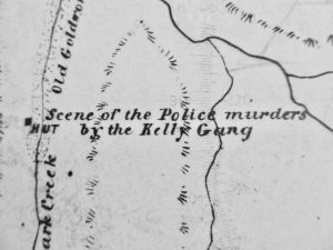
Ford has simply jumped to a conclusion which may or may not be correct, that Gatwards HUT and the ‘ruined hut’ are the same thing. But that is almost certainly the wrong conclusion, for the following reasons:
Ford makes the point both in the Documentary and in the report, that “A surveyors job is to accurately map the landscape and other features and it is unlikely that Gatward would have been any different so it is reasonable to assume that the location of the hut is accurate”. It’s important to recall that even in 1878 there was no actual hut at the police camp-site, only the remains of a hut – a few burned posts – and by 1885 when Gatward drew his map, they may well have disappeared entirely. But if we accept Fords reasonable point that Gatward did indeed ‘accurately map the landscape’, then we must accept that in 1885 at the place where he wrote ‘HUT’ on the map there must have been an actual real intact hut. Clearly, this actual real hut was NOT the hut that had been at the police camp site because it was already a ruin in 1878 and possibly lost without a trace by 1885. It was some other hut, probably one of the many that Ford acknowledged were to be found up and down the creek.
The argument might be advanced in Fords defence, that Gatward was documenting the site of a former hut, or of a ‘ruined hut’ . However, this cannot be sustained, because it’s not consistent with what Gatward did in regard to a hut at the site of the Kelly Gang camp on Kellys creek a mile away. There, as can be seen in the image below, Gatward recorded the presence of a hut at Kellys creek and wrote beside it ‘KELLYS HUT’, but then added underneath‘(Ruined)’
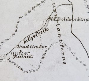
This annotation indicates that Gatward was well aware of the historical significance of the location, and the identity of the ruined hut at Kellys creek, that it was a relic of the Kelly outbreak and of the need to record exactly what was in the area, and its condition. That’s why elsewhere he also wrote ‘old’ gold workings. At Stringybark Creek however, what he noted was that close to the area where the police murders took place, there were old Gold diggings and a hut. He clearly did not regard that hut as having any particular historical significance, because, if he had, following the example of his annotations in relation to the hut at Kellys creek, he would have written something similar at Stringybark Creek to make it clear. But he didn’t.
Ford defies his own logic when he correctly asserts that surveyors like Gatward would have been ‘accurate’ but then implies that when Gatward wrote HUT he meant something else, that he wrote HUT at a place where there was no hut, or only ruins. That would not be accurate – it would be inaccurate and it would mislead anyone making use of the map, the opposite of what Ford himself acknowledges would be what the surveyor intended.
Clearly then, contrary to Fords assertion, there is no rational basis to claim that the hut shown by Gatward near Stringybark Creek was the ‘ruined hut’ photographed at the Police camp site. Fords claim that finding the Gatward hut is a key to finding the police camp is wrong. Ford may well have found the remains of the Gatward hut, but nothing links this hut to the site of the ‘ruined hut’ or of the police camp and shootout.
- The LiDAR Survey was based on a misinterpretation of the sources
The second part of Fords evidence that what he found were the ruins of the hut at the police camp, was data provided by the LIDAR survey. Ford repeatedly claimed that McIntyre said that the ruined hut and the place where the police pitched their tent was a flat clearing of one to two acres. On that basis, he commissioned the LiDAR survey to look for such an area, and indeed one such area of flat ground of one to two acres was located. No other similar sized flat locations were found along the creek so it was declared that the site of the police camp and the ruined hut had to be somewhere on that one area that was identified. All other places were thereby excluded from consideration.
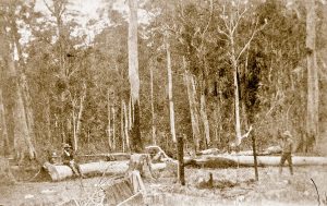
However, though Ford repeatedly said it, McIntyre did not actually say anything about the entire area being flat – he said it was partly cleared, and it was one to two acres in size. In fact, McIntyre’s actual words, and the Burman photos contradict the idea that the cleared area was ‘flat’ as claimed by Ford. McIntyre said that where the Gang approached from it was not flat – there was a ‘declivity’, a slope – and in the Burman photo there is an easily seen cleared area of ground rising behind the logs. None of the references quoted by Ford in his report describe the one to two acre clearing as being ‘flat’, though obviously, parts of it had to be, and such areas would be selected as the place to erect a tent or a hut. The flat area that can be seen in the Burman photos is very much smaller than an acre, so what was to be found in the rest of the cleared area not seen in the photo is anyone’s guess. It may have been flat, or it may have been sloping, broken, rough or steep but all we actually can say about it from McIntyre’s report is that in 1878 it was partly cleared. By 2018 regrowth meant that it was no longer cleared.
Thus, the premise on which the flat area revealed by the LiDAR survey was asserted to be the only area where the ‘ruined hut’ could have been, is false. It was never claimed by anyone that the ruined hut was on one to two acres of flat – or ‘flattish’ – land. Because of this error many areas big enough for a small hut and a tent that LiDAR could have identified were overlooked, excluded by the mistaken assumption that the ruined hut had to be on a flat area of one to two acres. Inevitably, the various sites nominated by the amateur archaeologists were thereby excluded.
- Ford misinterpreted the Burman Photos.
Ford was right to notice that the local topography at the signposted site didn’t match the topography of the police camp site captured by the Burman photographs. No matter in which direction you looked, at the sign-posted site no view matched the Burman photographs, which showed a slope rising behind the flat area where fallen logs and the police tent had once been. The blackened posts in the foreground of the photo are the remnants of a now burned, and ruined hut.
Ford wrote in the report that there had been debate about the orientation of the photos ‘for many years’ but said that following the discovery of McIntyre’s map in 2008 ‘it could be established that the image was taken from the south west corner of the clearing looking in an ENE direction’.Exactly how Ford decided that the McIntyre map gave rise to that interpretation is not made clear but again he is in error.
The orientation of the photos is established by the fact that the photo was staged by Arthur Burman to be a re-enactment of the ambush. His photo of the place where Sergeant Kennedys body was found was also a re-enactment, created by a volunteer lying at the foot of the tree where Kennedys body was found covered in a police cape. Burman had been shown exactly what happened and where by local saw miller Edmond Monk, who had himself been part of the search party and was personally informed by McIntyre only a few days before. People seen in the campsite photo were placed there by Burman to show Ned Kelly hiding behind a log with McIntyre to his left as Kennedy returned to the camp from the north. Kelly and McIntyre are therefore looking northward, which is towards the right side of the photo. This can only mean that the photographer was facing the west and south, in which direction a slope is seen rising behind the logs. Fords belief that the photos were taken looking in the opposite direction would mean that Burman placed the ‘actors’ in the wrong places and had them facing south instead of north and Kennedy approaching from the south and not the north. It makes no sense to imply as Ford does that Burman got it all so awfully wrong within just a few days of the event, especially in view of the fact that his informants were people who saw the bodies of the murdered police.
Ford claimed that a slope rising behind the Gatward hut site that he identified, supported his claim to have found the right place. However, this slope is north and east from the picnic ground, not south and west, so doesn’t match the Burman photo at all. The justification given by Ford for rejecting the sign-posted site, that it doesn’t match the Burman photo, is the same justification that should be used to reject the Picnic ground site nominated by Ford: it also doesn’t match the Burman photo.
SUMMARY
i) Ford misinterpreted the Gatward map, believing the hut shown on it was the ‘ruined hut’ the Lawless team was looking for.There is no basis for that claim.
ii) Ford misinterpreted the crucial evidence of the Burman photographs, believing the photos were taken looking towards the north-east but they were taken looking to the west and south.
iii) Ford misinterpreted descriptions of the camp site, wrongly believed the ruined hut had been on an area of one to two acres of flat ground, and thereby failed to search many other possible sites, including the two sites previously identified by knowledgeable local historians. IN fact nobody ever said the hut was one to two acres flat ground.
iv) there was nothing in the excavated site that directly linked it to the ruined hut they were looking for.
v)the topography shown in the Burman photograph cannot be replicated at the picnic ground.
CONCLUSION:
Archaeologist Adam Ford conceded in his report that his argument was entirely circumstantial. Never-the-less, in his view the various components of his argument when seen together were sufficiently ‘persuasive’ to justify his conclusion, that the remains he identified were in fact the remains of the hut at the police camp site, and therefore the place at which the police murders took place.
In fact, as shown here, the individual components of Fords argument collapse under careful scrutiny, and therefore his conclusion cannot be supported. He did not find the site of the police camp and the murders by the Kelly Gang. What he found was the site of a hut that was near SBC in 1874. That hut had nothing to do with the police camp.
PostScript: There was MUCH that Adam Ford got RIGHT in that first Episode of the Bushrangers Documentary and I will make a post about that very soon.
We didn’t like the Kelly episode of Lawless which we felt was a bit gormless.
The experts were self-proclaimed but knew little about the Kelly gang.
They weren’t from Victoria but should have contacted local experts to avoid the pratfalls littering the program. Regarding the police camp, they should have had a long chat with Bill Denheld.
Horrie and Alf
What makes you think Denheld is the man to call upon? Denheld got it wrong also
Patrick: Of course Bill didn’t get it wrong! His Two Huts Site is the O N L Y police camp site with the Burman photograph background. What part of this exceedingly simple fact don’t you get?
G R O A N !
David, it’s time to shut these gomerels and time-wasters out again!
Horrie and Alf
The flat acres of ground Mr Ford was seeking doesn’t actually exist anywhere. At Bill’s Two Huts police camp site, it is an optical illusion, as shown in the Burman photos. ANYONE can visit Bill’s site today and see the same ‘flat’ phenomenon with the exact same rise in the background.
Foxtel needs to be much more careful about who it gives doco dollars to.
The whole Lawless series was rather ordinary.
Roy
David, you are saying that Adam Ford and his team found/confirmed the ruins of a hut that corresponded with the hut location shown on the Gatward 1884 survey map of the area.
But this could not be the ruined/burnt hut that was where the police were camped. Is Bill’s site near this location?
Actually it was Adam Ford who said he had found the ruins of the hut marked on the Gatward map. He then argued that this was the ruined hut seen in the Burman photos but his arguments dont stack up.
Bills site is NOT near this location, which is the picnic ground. Bills site is the furthest south of all the suggested locations of the Police Camp, more or less on the other side of SBC from Ian Jones site, and heading north, separated by a few hundred yards, in order there is the CSi site, then Adam Fords site and now the furthest north site is this new Kennedy Tree Groups site.
I am looking forward to hearing the Kennedy Tree Groups argument and reading their Report, but it does seem they’re a bit nervous about letting anyone see their report, so I wonder if it will withstand thorough scrutiny?
Ive made no secret of the fact that I have thought for quite a while that Bill is right, but even he openly states he is willing to be proved wrong. The point is, its not a religious belief we are defending but a scientific approach to uncovering history. To date Bills argument is the most persuasive and logical, but who knows maybe the Kennedy Tree Group will have an even better case.
Thanks David, ok, so the remains of a hut were found at the location marked on the Gatward survey map but those remains are highly unlikely to belong to the burnt hut seen in the Burman photos. So why would the surveyor say that the scene of the murders was near the location of the hut shown on the map?
The surveyor did NOT say that the scene of the murders was near the location of the hut shown on the map. What he did was make a map of the area and put on the map the things that he found or knew about the area. It so happened that in 1884 there was a hut near the scene of the police murders, and it was also near old gold workings . As I wrote in the Blog piece, given what he wrote about the hut at Kellys creek, it would seem likely that if the hut at Stringybark had anything to do with the Police camp he would have noted it – but he didnt.
Gatward did not say but wrote “Scene of the Police murders by the Kelly Gang” on the survey map. This being in the general region of the picnic ground.
Heritage and History on My Doorstep. By Sheila Hutchinson. Available from the Mansfield Historical Society. A time consuming effort and a credit to the author.
Most of the information therein was gathered from local newspapers. Mansfield Independent, Mansfield Guardian, Mansfield Courier, Benalla Standard, Benalla Ensign
From Page 102. Year 1911. The Toombullup Tramway (Tour)
“The party then went to the spot where Sergeant Kennedy and the other members of the police force were shot by the Kelly’s. Mr Wright settled in the district about three months after the incident, and remembers distinctly seeing the tent in which the police were camped and the remains of the charred blankets. The party also saw the sight of the old hut of the Kelly’s, and the bullet marks on the tree which they used to practice revolver shooting.”
From Page 106. Year 1913. A scenic and Historic Route Mansfield to Buffalo.
“The scene of the tragedy at Stringybark creek, in the Wombat ranges is still clearly indicated. It is an open space, and there remain the ruins of the miner’s hut, used by the police as a camp, and a log scooped out to form a wash basin. But these relics are rotting away, and soon there will be no distinctive memorial of the historic spot. But the creek is not fifty yards distant, and it would be but a small labour to collect stones from it and erect a cairn which would not only be a lasting landmark, but would also be a lasting memorial to the brave men who sacrificed their lives in the performance of their duty.”
The site of the police camp was still visible in 1913, so would have been obvious to Gatward at the time of his survey. I see no reason why the general location written on the 1884 survey map should not be considered correct.
I agree with you : the general location on the survey map IS correct – but I emphasise your words ‘general location’ . I illustrate my point this way : Imagine for a minute that someone knowing nothing at all about the murder site apart from what was on that map, decided to go there and search for it: the place he (or she) would search would be entirely the wrong place because the label indicates that the site of the police murders was to the EAST of Stringybark Creek, and encompasses an area between SBC and Ryans Creek. In fact NOTHING happened in that area to the EAST of SBC labelled as “Scene of the police murders by the Kelly Gang” So, to that extent, although the label is in the general area, Gatward didnt get it exactly right. Agree?
And one more thing, now its clear you’re a ‘player’ in this debate, are you going to declare which is your preferred site?
The borrowed police tent was burnt by the Kelly Gang. It’s in the Macfarlane book “The Kelly Gang Unmasked”.
Cam West
(Third time sent)
David, given that it can be agreed upon that the general location was near the picnic ground and that Bill’s site is not near this location, it removes that site from the equation. You may think differently, but as far as I’m concerned there is no reason to pursue that any further.
I accept your point that someone knowing nothing at all about the murder site may go searching on the eastern side of the creek. But someone who did hold some knowledge about the site would not. Gatward may not have got it exactly right (pinpoint the exact location) but did make note of the hut and wrote his words adjacent to it. So it would appear that the hut held some form of importance as to the general location. In answer to your question….No I am not going to declare which is my preferred site. But will continue to produce information that may be helpful.
As my name is being mentioned I would add this to the debate.
On this page 18th Nov at 5.10 pm, Anonymous thanks David with perhaps a miss-understanding that a hut was found where Gatward’s 1884 map marked one? I would like to add there was no hut or evidence of a hut found at that Gatward location as indicated. In 2003, I calculated ‘that hut’ to be the 0.8 km south along SBC road from the SBC/Ryans Cks junction taking the road dogleg into account.
In 1885 a second Gatward parish plan for the area was produced, Gatward then marked the same hut with the same notations ‘ Kelly gang shot police’ but this time the before mentioned hut was 162 metres further north from the first hut plot. This site was also plotted by me as being near the northern picnic ground fence some 35 m in. I metal detected that area as well.
In the hope to capture the middle ground as on average, Adam Ford decided to do a dig- up an area right in between these two hut plots where as I had learned in about the 1960-70s the Shire Council had established some BBQs in and around the ‘current Kelly tree’ but to the north. In 1985 when visiting there our family used these BBQs and I even have photos of us there with a BBQ in the back ground close by where Ford established his hut site. There was still one hidden there in the bushes around 2010.
To help understand relative locations I link this image.
http://www.ironicon.com.au/images/two-huts-site-in-3D.jpg
Attachment
Thanks Bill. I take your point that what Adam Ford excavated wasn’t proved by him to be a hut site, though I accepted his argument that what he found was consistent with it being one. In fact, the artefacts such as broken glass and ceramic fragments were not actually dated but just described as being of a style and design thats ‘consistent with mid to late 19th century occupation’. I guess if it was a BBQ site broken glass and cups might be found there too!
I really like that Google earth map you’ve supplied because it shows the line up of all the sites along SBC and various other interesting bits of info. Can I just ask what is the distance from the creek Junction to the Two Huts site and the CSI site?
David, the distance from junction of Ryans and SBC are as the crow flys,
To the Two huts site with slope in the background = 1010 m from Ck junction
To the CSI team site = 800m
to Adam Fords Lawless Bushranger about 700 m
The previous image is not to scale due to 3D distortion but this map is to scale.
http://www.ironicon.com.au/images/sbc-map-distances.jpg
Attachment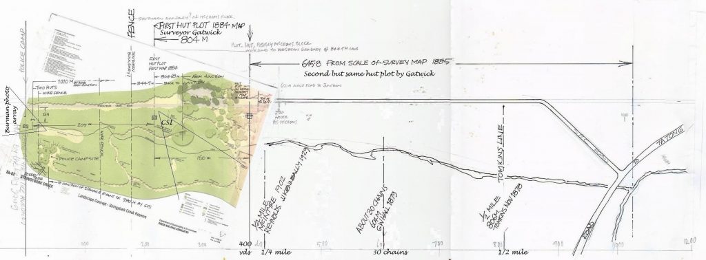
Sorry you had to send it more than once : usually I get en email that says a new comment is waiting to be moderated but not this time for some reason!
But hang on – I havent agreed that Bills site isn’t in the general area of the picnic ground – I would say ALL the sites are in the general area of the picnic ground – a five minute walk from the picnic ground leaves you still in the general area!
So I would say your dismissal of the two huts site on the basis of your own private entirely arbitrary interpretation of what it means to be in the general area is unsustainable. I reject it.
But you are also making things up by saying that the hut had ‘some form of importance’. The hut was an actual reality at that place in 1884 and that is the sole reason that it appears on the map. There is NOTHING recorded that allows you or anyone else to assert anything else about it. In fact, as Ive pointed out with reference to what Gatward recorded at the Kelly hut, if that hut DID have some importance attached to it, then there is EVERY reason to believe Gatward would have stated it. BUT HE DID NOT .
So do have any more information that might be helpful?
Arbitary: Based on personal choice or random whim rather than any reason or system.
I have provided documented evidence that the site of the police camp was still clearly visible the time Gatward did his survey. The hut was an actual reality at the time of his survey and he clearly noted it as a marker, this being the only hut he noted on the survey along SBC. Adjacent to the hut he wrote: “Scene of the police murders by the Kelly Gang” The hut site is located between the picnic ground and the Kelly tree. “Bills site is NOT near this location, which is the picnic ground.” Separated by a few hundred yards to the north of the site on the survey map. My dismissal of Bill’s site is not based on personal belief.
What was ‘arbitrary’ about your claim is the definition of what being in the ‘general area’ means. On what basis have you decided that the Two Huts site is too far away to be described as in ” the general area “? Is there a dictionary definition or an agreed formula anywhere that states how near or far away a thing has to be from some other thing to be or not tone in its general area? If the term used had been ‘immediate vicinity’ or if Bills site was as far away as the Kelly camp then you might have a case but the phrase ‘in the general area’ is a very vague term and I would be surprised if many would agree with your claim that five minutes away takes you out of the ‘general area’.
I accept that you have provided evidence that people were being shown a place they believed was the site of the Police camp, but there is NO evidence on Gatwards map that he really had any idea of exactly where it was. It would have been very easy if he knew exactly where it was to have marked precisely where it was, and to have labelled that hut as being at the site of the police campsite if it was but he didnt. All he seemed to know about the place when he drew his map was that the police murders occurred somewhere in that general area – and we agree he didnt really get that right! His annotation covered an area that extended right across Equinox Creek almost to Ryans creek ! The point is this map is NOT a highly accurate detailed record of precisely where the murders took place and it doesnt link that hut with the police camp. It just happened that in 1884 there was a hut there.
And we must also agree surely that the hut that he saw there was NOT, absolutely could NOT have been the actual hut whose ruins were photographed by Burman because he called this a hut, not ruins of a hut as he did with the Kelly hut.
You say your dismissal of Bills hut is not based on personal belief, yet it is your personal belief about how near something has to be to something else to be able to say its in the general area that you’ve said above is the reason you dismiss it. Youre perfectly entitled to dismiss it on whatever basis you like but the idea that the Two Huts site is too far away to be defined as being in the general area indicated on that map, and therefore should be dismissed on that basis is nonsense in my view.
As usual we are befuddled by the comments of anonymous blow-ins who disagree with the convictions of most of us here – “My dismissal of Bill’s site is not based on personal belief”. What on earth does that mean?
We’ve been to Bill’s two huts site and believe it is the site of the police camp.
Horrie and Alf
Horrie, how can your dog Alf possibly have a opinion?
Dogs are very clever and they have opinions about everything! Never underestimate them!
Attachment
For the benefit of all readers. Horrie’s dog Alf sniffs around a lot like me.
Ever since Linton Briggs, Gary Dean, Kelvyn Gill and Glenn Standing proposed the police camp as being near the Kelly tree circa 2009, and then fairly recently in that Lawless Bush Rangers- Ned Kelly tv program, Adam Ford as the hero SBC archaeologist, tried to convince the un initiated to believe he knew his stuff, but NO ONE has ever produced a photo of their site even slightly comparable to the Burman 1878 photos. The reason being, at their sites THERE IS NO SLOPE as in the Burman photos. I ask this Anonymous to post a picture of his/her preferred site to show some ‘flat ground’ capable on which ‘big logs’ could be laid in form of a Y formation, with a ‘steep slope’ in the background, and trees on top reaching to the sky- a image divided into 3 equal parts, – 1/3rd flat ground, 1/3rd slope, and 1/3rd trees to sky, this is what the Burman No1 consists of, so forget the second Burman photo which only shows the start of the slope towards the creek which is on the LEFT side.
Here is another Google Earth 3D image, a screen shot showing the REAL shape of the land .
There can ever only be one police camp site.
http://www.ironicon.com.au/images/two-huts-site-in-3D-2.jpg
Attachment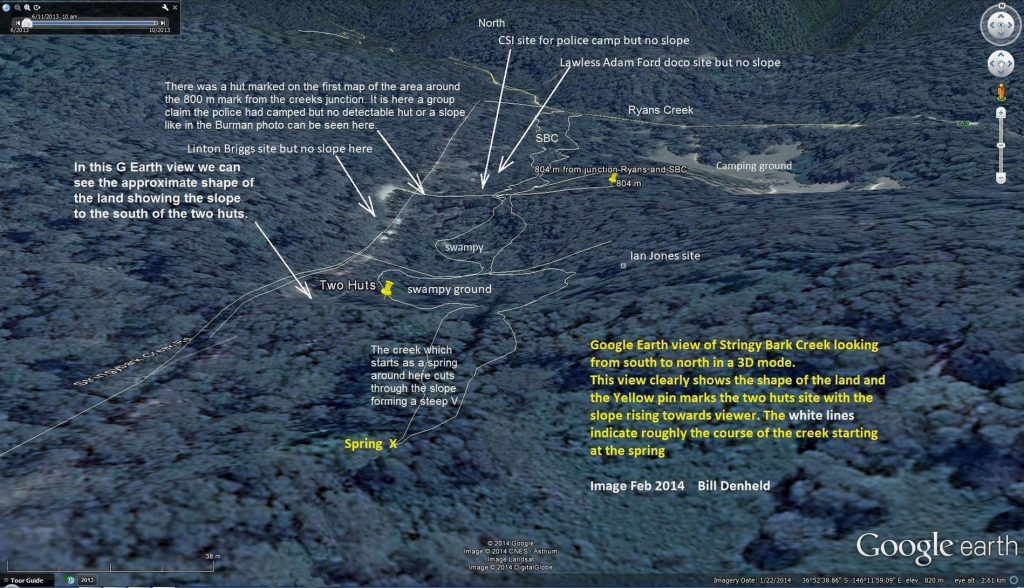
David, those were the suspects we were thinking of who contributed to your “The Great Debate about Stringy-Bark Creek” Forum (as did “Sarah”, remember him)?
Post by Guest Horrie on Feb 28, 2014 at 7:53pm
Are we there yet?
Kelvyn, nobody can accuse you of being brief and to the point.
I have read the above four or five times and still can’t make any sense of it.
Surely there is someone on your team who can do dot-points?
If the above is the CSI presentation in response to Bill’s, I’m not impressed.
We want more than he said, we said, he said, over and over. Where does that get us?
I’m almost tempted to get the report on inter-library loan. But promise me it isn’t as dreary as suggested above, and that it isn’t just a 97-page attack on Bill.
[Alf used to growl loudly when he saw posts from Kelvyn and “Sarah”. He may even have contributed posts himself, and with me later].
Horrie and Alf
Horrie I know we have ben through much of this before, and I am glad that the Kelly troll – or should I say Kelly Toad “Sarah” hasn’t returned to sabotage everything – so far, at least – but I welcome contributions from people like the ‘Anonymous’ who has been contributing today. I welcome debate and the challenge, and we have both made our points and anyone can read them and make their own decisions about who they think makes the most sense.
I also like the fact that we are discussing something other than the myths and lies spun about Ned Kelly for a change. It will serve as an awakening to everyone of the issues involved in this niche corner of the Kelly story, and when we finally get to see the whole Kennedy report, will be better prepared to understand it and. to evaluate their claims to have discovered the tree and the police camp site.
Absolutely David!
It’s just that Anonymous is hair-splitting, dithering and not answering any of your specific questions – such as, is there any other site that has the Burman photo backdrop. It is dishonest to say Bill is wrong when (as everyone now knows) his is the ONLY site with the Burman background. You asked Anonymous to provide alternative sites with identical Burman backgrounds with No response.
We think this Anonymous is just another of the time-wasters who periodically venture here to distract you and us. They are getting slightly more sophisticated, but still never provide the evidence you ask for.
That’s because they can’t.
Yawnorama!
Horrie and Alf
David, I’m not going to entertain the idea that a hut site determined by a qualified archaeologist/s could be mistaken for a BBQ.
I’m not suggesting the hut site found/confirmed by Adam Ford belonged to the burnt hut seen in the Burman photos. (Photo 1 & Photo 2 have no idea which one is which)
I am certain that if Gatward had written his words near a hut at Bill’s site, and I was to say that the picnic ground was within the general location, that being a few hundred yards away you would scoff at it.
You have a vested interest in Bill’s site and understandably want to defend it. That’s Ok. I will listen but not always agree. That is the nature of it.
The Piltdown Man was a paleoanthropological fraud in which bone fragments were presented as the fossilised remains of a previously unknown early human. The inauthenticity of the hoax was described in 1953. There have been many later, similar frauds. I am NOT for one minute suggesting Adam Ford is in that category. He definately isn’t.
But there are heaps of examples of archaeological mistakes, and archaeological finds that have been misinterpreted.
What’s more, Adam Ford’s BBQ site DOESN’T have the Burman background.
Cam West
Well Adam Ford certainly got some things wrong dont you agree? For example claiming that McIntyre said the Campsite was on one to two acres FLAT ground? And that Gatwards hut WAS the hut at the police camp site? I am not familiar with the BBQ claim but if Adam Ford hadn’t even considered it at all, couldn’t he have mistaken an old BBQ site for a hearth? Its plausible at first sight.
But if Gatward had drawn a hut near Bills site, I hope I would have had said well it isn’t THE hut because it didn’t exist in 1884, it was another hut in the same ‘general area”, of which Adam Ford said there were many up and down the creek.
I am going to be interested in your comments about the Kelly Tree teams claim to have also found the police campsite. If you’re a CSI site supporter then you will need to reject the new site because its firmly based on interpretation of the Burman photos, and crucially a belief that they were taken looking to the west and south, the opposite of what the CSI team based its claims on.
I suppose there are a few qualified archaeologists who don’t use some guesswork in their findings. I found the Lawless programme to be very ‘iffy’ and poorly researched and presented.
The “experts” were from the Uni of Adelaide…
Foxtel History is remarkably shoddy. Most programs feature their own history PhDs, Masters graduates and sometimes lowly students all pushing their favourite hobby horses, and big-noting themselves.
I rarely watch any more.
Roy
I have been carefully following the comments here. Anonymous keeps referring to Gatward’s map. This map hasn’t been a big issue or debating point before and is probably irrelevant anyway.
The Burman photo background, which you, David, have repeatedly challenged Anonymous to show any other police camp site possesses just gets ignored.
Rebecca
Yes I agree the hut marked on the Gatward map IS NOT relevant to the search for the Police Campsite . Thats because it is NOT identified in any way as being anything more than a hut which happened to be on Stringybark Creek in 1884. Its proximity to the region WRONGLY marked as “Scene of the Police Murders by the Kelly Gang” is pure co-incidence. If it had been otherwise, this would have been noted by Gatward, as he did at the hut on Kellys creek where he noted a ‘ruined’ hut known to be the Kelly hut, which I what he labelled it as.
Adam Ford and any one else who argues otherwise is making a link that is simply NOT there.
Hello Rebecca, nice to see you here.
This might help all those honorable SBC investigators trying to locate the true police camp and what to look for on the ground.
http://www.ironicon.com.au/images/burman1-photo-3-spots.jpg
There is no mistake if you can match these circled spots. Match those 3 spots looking southerly and you’ve got it.
Bill
Attachment
I really disliked the end of the Lawless Kelly episode where the archaeologist showed Sgt Kennedy descendant Leo where his GG grandfather had been murdered. Based on the errors in the show, it was a rather unlikely this was the spot. Poor old Leo drank it up.
He had earlier accepted Bill’s correct identification of the actual site.
The power of tv.
Cam West
So thats the third tree that Leo has accepted as being the one his ggrandfather was killed beside? I think this illustrates just how difficult identifying this tree is, when three different teams have come up with three different, presumably credible candidate trees in the area. We don’t actually know if the tree is still there – all thats happening is people are finding trees that MIGHT be it.
To be honest I am more interested in the Police campsite.
Another correction exercise I am afraid Cam. First off Michael Kennedy is the grt grandfather of Leo Kennedy I believe not grt,grt as you say.I can assure you Cam Leo also is no fool either with your comment of poor old Leo drank it up.Leo is a lot smarter than you seem to indicate. I believe in the Lawless video it shows Leo removing his hat but not in front of a so call identified tree but a general area. We all have to wait for The Kennedy Tree report before making an opinion on it, although some here are not giving their team the chance and criticism of it already. After nearly 15 years a few more months wont hurt. In my case anyrate.
If you have a look at Bill Denhelds site his earlier efforts to find the Michael Kennedy murder site focused on the Germans Creek area and not to the NE of SBC road and the picnic area as was the case where he showed Leo a certain tree. Towards the end of 2017 just before Christmas I asked Bill why he had changed his mind on the murder site.?I will not say what Bill told me but I am sure Bill can inform you all.
Just as Bill has changed his opinion on the MK site I changed mine on the police camp site after viewing all the evidence and viewing all the opinions. I am still probably no closer to finding out than when starting off about 15 years ago. I have absolutely no idea where Michaels death occurred at all.
I believe the anonymous on this link has put forward a very good case and in my book is heading in the right direction. The criticism of quite a few on here is quite unjust. The bloke has put his case forward very well but as everyone knows I don’t like people with no proper names. Bill has also stated that many times over a long period. I certainly do not know who this person is but maybe someone that Bill and I have dealt with in the past. I have absolutely no idea.
Robert: The insuperable problem for disbelievers of Bill’s police camp site is that it is, among other things, the only site with the Burman photo background Other people have identified police camp sites, but all of them (so far) lack the Burman background. Without it they obviously aren’t the police camp.
I accept Michael Kennedy wasn’t Leo’s GG granddad and did not intend disrespect. Let’s just say he is a bit gullible about Kennedy trees.
I disagree with your generous summary of Anonymous who still hasn’t made any meaningful contribution here yet.
Cam West
David, we re-read your expose of the CSI Report and laughed out loud about the many absurdities to be found in it.
https://kellylegend.blogspot.com/2016/09/the-csi-sbc-report-is-pseudo-science.html
Horrie and Alf
David,
Pictures of dogs, talk of trolls, a Kelly Toad “Sarah”, 3D images of the lay of the land, visual interpretations of a Burman photo, slopes and a BBQ for a hut site. Now a photo of a man from the NKDG Cricketers Bar and Archive.
This analysis from Rebecca : “I have been carefully following the comments here. Anonymous keeps referring to Gatward’s map. This map hasn’t been a big issue or debating point before and is probably irrelevant anyway. The Burman photo background, which you, David, have repeatedly challenged Anonymous to show any other police camp site possesses just gets ignored.”
Your answer “Yes I agree the hut marked on the Gatward map IS NOT relevant to the search for the Police Campsite” …..……Little wonder debates have been going on for years.
Some of the debates have been going on for years because some people refuse to accept the bleeding obvious, such as the absence of any good reason to believe that Gatwards ‘hut’ has anything to do with the Police Camp site, or that Burman would have recreated the ambush scene at the Campsite as accurately as the limitations off his equipment would allow.
As for the picture of the dog – if it didn’t melt your heart you need to take a chill pill Anonymous – this debate is. not about the end of the world but a minor point of interest to a few enthusiasts.
David,
Disparaging comments made about Adam Ford are not constructive. To suggest that the confirmed hut site may have been mistaken is nonsense, wire, nails and other items were found at the hut site “their style and design and the nature of the nails are consistent with a mid to late 19th century occupation’’ There may have been other huts along SBC at the time of his 1884 survey but the hut shown on the Gatward survey is the only hut he noted. Indicating the importance of that hut relative to the scene of the murders. If there was to be found an early survey map with a clear indication that the scene was actually several hundred yards further south, then so be it. But none has been produced. Would have is an assumption that Burman recreated the ambush scene as accurately as possible.
Basically what you are indicating is: If the location on survey map does not match Bill’s site then the map is wrong. Not Bill’s site is wrong if it does not match the location on the survey map.
Mansfield Courier. 25th April 1908.
“Last week a historical tree known as the Kelly tree, Toombullup, where Sergeant Kennedy and the other police were shot, was cut down by the employees of the Sawmill Company. Some special timber was required and this tree, being available, was cut down.
A portion of it, measuring 26ft in length, was brought into Benalla last Friday for transhipment to Albury.”
The site of the police camp was well known and still clearly visible after this tree was cut down. In 1911 locals such as Mr J.Wright who settled in the district only months after the incident new the exact location of the murders, along with the many visitors.
In 1913 the remains of the police camp was still clearly visible. The current Kelly was marked by a local in 1933.
The hut location shown on the 1884 survey is between the picnic ground and the current Kelly tree. The current Kelly tree location is also not near Bill’s site. Why not?
Anonymous, consider this:
Suppose when Gatward was making his map at SBC he came across a hut that he knew had nothing to do with the Police murders, a hut built maybe two or three years after the murders. What do you think he would have done?
I think he would have recorded that there was a hut there. ( which is what he did !)
Now suppose he came across a hut that he KNEW was related to the Police Murders. What do think he would have done NOW?
I think he would have recorded that there was a hut there and made a note on the map that it was in some way related to the Police Murders. ( which is exactly what he did at Kellys creek!)
Your refusal to accept these simple reasonable arguments makes no sense at all. Your position is a blindly dogmatic insistence that even though on the Map there is not one single thing that suggests the hut had anything to do with the Murders, the hut WAS connected to them.
But here’s another challenge for you : if someone was to assert that that hut was a miners hut and was built by someone reworking the old gold workings, what comeback would you have? The answer is nothing – that person would be using the same ‘logic’ you are – nothing links that hut to the gold workings OR the Police murders – all we can say about that hut is that it was present when Gatward drew up his map in 1884. Speculate all you like – as Adam Ford did – but declaring you’ve found it doesnt mean you’ve found the police camp. All you’ve done is find a hut that was there in 1884.
And we haven’t even discussed Bills claim based on an 1885 version of the map that the Gatward hut was actually a long way further north! Where would THAT leave your CSI claims?
And one other thing – in answer to your question about Bills site not being near the Kelly tree. Firstly its about as far away as Ian Jones site was, and that was accepted as not too far away for decades. And secondly if you look at Bills 3D Google map above you will see the original tree was very close to the two huts site – and so is a Spring!
Anonymous (November 24, 2019 at 1:34 pm) you keep citing Mr J. Wright as an expect on the police tent and its location..
The borrowed police tent was burnt by the Kelly Gang. It’s in the Macfarlane book “The Kelly Gang Unmasked” (p. 81) – so newcomer Mr Wright, who settled in the district about three months after the incident, and remembers distinctly seeing the tent in which the police were camped.
Stop it. No he didn’t. It had been burned by the Kelly Gang three months earlier…
Cam West
Cam, I am citing the words from the newspaper article. Yes. The tent was burnt along with the blankets. I assume in the same location. The burnt remains were still visible to Mr. J. Wright.
Anonymous: Don’t know about you, but I can’t properly identify burnt stuff. These days forensic people would be all over the charred remains. Back then maybe they didn’t.
Whether or not Gatward was an accurate surveyor would be found in the State Archives. Included among the files are Surveyor’s work books and diaries. Not only that, but associated correspondence files would show if surveyors work was satisfactory or not.
I have also a copy of Ian Macfarlane’s book ‘Eureka: From the Official Records’. It shows that Ian examined the work of Surveyor Eugene Bellairs in most of the records about him at the State Archives. Bellairs did a survey of the surroundings of the Eureka Street and the Eureka Stockade. Ian’s book is heavily footnoted (like his Kelly book), so you could probably follow his research and find records about Gatward – maybe even relating to his time in the surrounds of SBC.
I think Gatward and his hut are a furphy. You have wasted heaps of our time.
Have a happy life.
Cam West
Regarding the Mansfield Courier. 25th April 1908 above – “Last week a historical tree known as the Kelly tree, Toombullup, where Sergeant Kennedy and the other police were shot, was cut down by the employees of the Sawmill Company. Some special timber was required and this tree, being available, was cut down.”
Was that tree the same as the Kennedy Tree that is now being talked about? If so, the Kennedy Tree Group are barking up the wrong tree.
No Jason, an interesting report but I think it was a ‘Kelly’ tree at or near the police camp, not the Kennedy tree half a mile away that was cut down. I think the Mansfield Couriers report was a bit sloppy in its description of the Kelly tree being the place where “Sergeant Kennedy and the other police were shot” because we know Lonigan and Scanlan were shot near the Kelly tree but Kennedy was shot near a different tree.
David, just to be clear are you referring to the November 21st post of Bill’s 3D Google Map?
Also this has nothing to do with the “CSI claims” I am just an independent observer.
This one : creek, spring, boggy ground, original Kelly Tree – all near the Two Huts site
Attachment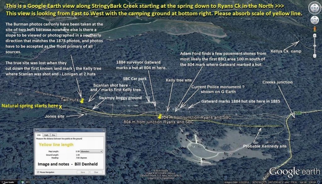
David
The question was; “The hut location shown on the 1884 survey is between the picnic ground and the “current Kelly tree”. The current Kelly tree location is also not near Bill’s site. Why not?”
The 3D google map provided clearly shows that is not.
“if you look at Bills 3D Google map above you will see the “original tree” was very close to the two huts site”
There is no evidence to support that apart from what Bill has written about a site, that is several hundred yards away from the locations shown on both survey maps, and the current Kelly tree marked by a local in 1933.
Back to what I said in the beginning :“Bill’s site is not near this location, it removes that site from the equation. You may think differently, but as far as I’m concerned there is no reason to pursue that any further.”
So you’ve gone all the way back to where we started from, to your arbitrary definition of what ‘near’ and ‘general location’ mean, and to your unsupportable contention that the Hut was something to do with the Police campsite.
But as you have NO basis to assert anything about that hut, you have no basis to assert anything about exactly where the police campsite was, and given that Gatward clearly did NOT know precisely where the Campsite was – as evidenced by his labelling as the site of the murders an area that we KNOW was NOT the site of the police murders – the reasonable person would say that any site in that general area is a potential site- where ‘general area’ is not defined in such a narrow way as you do.
In regard to your claim that the Two Huts site is not ‘near’ the Kelly Tree – again, that reduces to what is meant by ‘near’ and in my opinion a couple of hundred yards is ‘near’ but as I alluded to before, Bills claim is that the original tree was much much closer.
I am wondering if you think the KTG site will be ‘near ‘ enough for you?
Anonymous wrote 24th at 1.34 pm
“ ”The hut location shown on the 1884 survey is between the picnic ground and the current Kelly tree.
The current Kelly tree location is also not near Bill’s site. Why not?” ”
Anon,
The hut location on the 1884 survey is NOT between the picnic ground and the current Kelly tree. That 1884 hut site is about 50 meters south (up the creek) from the Kelly tree. And the picnic ground is 70 metres (down the creek) north from the current Kelly tree.
Anon, to answer to ‘why the Kelly tree is not near Bill’s site’ is because the two huts and its general location was just outside the second land owners ground, in an area rather difficult to get to and with boggy swampy ground to the north. It was this second land owner ‘Beasley’ that got tired of taking people to the spot and he marked a dead tree near the road not far from his house. See the photo of Mr Cuddon in front of it. This tree fell over and in the early 1930s another tree was chosen and this time attributed to the dead police and was known as the police tree. In the 1970s a local sculptor placed a Kelly mask over the police names inscription ‘ blaze’ and it became known as the current Kelly tree. The original Kelly tree where Scanlan was found was 240 metres south of the current Kelly tree.
Naughty Mr Beasley….. Hitchens’s Razor
Of all people to quote Hitchens, the last I would expect to do so would be the person asserting without evidence that the hut drawn on Gatwards map has anything to do with the Police campsite!
Attachment
Ref. Below: “If it that hut was directly connected with the police camp is up to others to decide.”
Bill , anonymous is asking you to justify your claim that Beasley got tired of taking people over to the true Kelly tree site and just marked a random dead tree near his house as the Kelly tree. I would like to see that too, but I dont doubt you will have the evidence somewhere.
In the Age 10 Oct 1995 Ian Jones was interviewed by John Lahey, a feature story ‘Ned Kelly Revised.
I will post transcript below the Jack Healy in Womans Day article.
David, Yes, I agree, “relative to the scene of the murders” the hut might not have been on that site at the time, but was there in 1884 at the time of the survey. Gatward wrote scene of the police murders by the Kelly gang adjacent to the hut. This being the only hut he marked on that survey. Indicating that that was the area of the murder site. If it that hut was directly connected with the police camp is up to others to decide. The second 1885 Gatward survey shows the words Police Killed by the Kelly’s in a broader more generalised area across the map. Both survey maps show the site area to be several hundred of yards north of Bill’s site. The site of the police camp was still visible in 1913, so they would have been visible to Gatward at the time of his survey. The locations given on both surveys maps are closer to the picnic ground/ police memorial than Bill’s site. As is the current Kelly tree.
I have no comments to make on the KTG site. But the indication is that at least it is heading in the right direction. North of Bill’s.
These will be my last words on this topic:
1. On his 1884 map, Gatward labelled the WRONG area as being the scene of the Police murders, He labelled the “scene” as being an area that extended from the eastern side of Stringybark Creek right across almost to Ryans Creek. This was NOT the area where the Police murders took place but they did occur in that ‘general area’ – in fact to the west of SBC.
2. The Hut drawn near the old gold workings on the eastern side of SBC is also in the general area of the police murders but it is NOT the hut that was at the same place as the police murders because that hut was a ruin in 1878
3. There is nothing recorded on the map to suggest that this hut was of any particular significance. It just happened that in 1874 it was in the general area of the police murders. To claim this labelled hut was in some way related to the police campsite hut is pure ,and baseless speculation.
4. No site along SBC could be ruled in or out on the basis of what is recorded on Gatwards map, because of the inaccuracy of Gatwards labelling : the murders did NOT take place in the area he has labelled as Scene of the police murders by the Kelly gang”.
Further to my above post regarding the location of the original Kelly tree, I thought this image would help. The parish map at right shows Jack Healy’s land near his neighbour Beasley at SBC. All the locals would have know where the true site was including Beasley. It was Healy that showed Ian Jones the site in the 1960s but Jones did not believe him, but 30 years later he realised there was something very wrong with the current Kelly tree location. At the time Healy showed Jones the place it may have been very over grown like it is today, but Ian was attracted to the open area on the east bank which sort of felt right, and its ironic that when Ian wrote in his paper ‘Ned Kelly Man and Myth symposium that ‘ if someone’ would find the remains of a hut nearby, that would certainly pinpoint the site of the police camp.
With Jack Healy’s revelation in Woman’s Day, it’s a wonder Jones did not go back and have another good look, because when I stumbled over the first rock fireplace of a hut while there with Gary Dean in 2002, we both knew it was important. Gary said ‘don’t tell Ian Jones’ about this, but months later I rang Ian and told him I’d found two fireplaces – response- stony silence. I offered to take him there but every time I rang I got his wife Bronwyn who said he would ring me back- but he never did.
http://www.ironicon.com.au/images/jack-healy-on-sbc.jpg
Attachment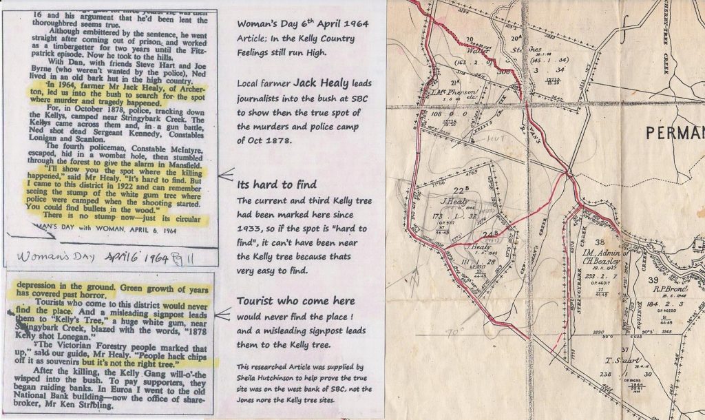
Anonymous asked for source of “Beasley being tired of taking people over to the true site’-
The Age, 10 Oct 1995 Ian Jones was interviewed by John Lahey, a feature story ‘Ned Kelly Revised.
“Mr Jones says that in 1960 he learnt there was once a local man who grew tired of people asking where the battle took place, so he randomly cut a legend into the Kelly tree to put an end to it. Everyone simply accepted that here was the true site. In time the site became formalized for parking. The tree now carries Ned’s metallic likeness. The same man who told Mr Jones about the tree said the real site was further south along the creek and described it. From that day, Mr Jones set out to find it.”
Age author John Lahey follow Jones to the site where the police pitched their tent –
Lahey- listens to Jones and-
“ at an abandoned hut on a rise, and here is the only place it could have stood. Looking west from the east bank, you see a hillside uncannily like the one in the old photos from the time. And then there’s the swamp. Constable McIntyre, the only policeman to escape the Kelly’s bullets galloped off across the swamp immediately to the north.”
We can deduce the man who marked the tree was land owner C. Beasley, and the man who told Ian Jones all this was Jack Healy. The only problem for Ian Jones was that he was SO adamant the site was on the East bank, and therefore to suit his scenario, McIntyre on horse layed tracks that MUST have crossed the swamp and the creek to be heading west from Jones’s east bank site. We now know the true site is at the two huts fireplaces and those horse tracks crossing that swampy ground immediately north and crossing the creek onto the east bank. These horse tracks were followed by Const James a week later, he stated ran for several hundred yards, then turned left and headed west.
The search party on the first day looking for Sergeant Kennedy had searched to the North West of the camp without success. The following day another search party met at the police camp and from there, and at the suggestion of Shire President Tomkins, they followed McIntyre’s tracks to the east of SBC – where at about 1/2 mile the body of Kennedy was found**
Days later there was some orientation confusion and the coroners record shows east crossed out and changed to west.?
**( source Telegram to Super Intendant Pewtress )
Bill,
“It was this second land owner ‘Beasley’ that got tired of taking people to the spot and he marked a dead tree near the road not far from his house.”
You having given us an interesting read. Thank you. But does not provide any evidence that Beasley just randomly marked a tree near his house/Kelly tree site.
Have you any other evidence that you can provide?
(For the record I did not make that post Nov 26 @3.55pm)
The current Kelly tree is not the right tree, place where the shooting started.
http://www.ironicon.com.au SBC Dee-bate Page 10. Charlie Engelke letter.
http://www.denheldid.com/twohuts/story.html (Story 5)
Picture of the rooted out stump looking towards the West (Charlie Engelke) with the road in the background. (Not S/E.)
The Cuddon photo. Looking N/E. This tree said (Charlie Engelke) to be near and adjacent to the stump of the Kelly tree. The current Kelly tree said to be seen in the left background.
This info taken from the new sign at the Kelly tree. (The info assumed to have come from a different source than that of the above)
“When new roads were built around Toombullup in the 1920s, it became much easier for travellers to visit Stringybark Creek.
In response to public interest, the property owner Charlie Beasley placed a fingerboard marker on a ringbarked dead gumtree close by the stump of the original marked tree.”
Some food for thought: From An Observer.
Footnote:
Note the location of the 1884 survey on this image.
http://www.ironicon.com.au/images/two-huts-site-in-3D.jpg
Yes he did. Tell the truth please Mr Den Held.
Jones got the site completely wrong, Mr Anony Mous. No one believes Mr Pompous Jones was right about it now. But Jones put a lot of crap on people who disagreed with him about that and about anything to do with Ned Kelly. He wasn’t very nice really.
I did speak to Ian, so you can now Tell us the truth please Mr or Mrs Anonymous.
Tell us what he told ABC presenter John Faine on Melbourne radio 774 AM regarding my newspaper article in the Age 10 Feb 2003 about my findings, this was only five months after I had rung him. Please inform us all of the truth please because anons are not fond of it.
David: There must be a filter for Forums like this to help identify and prevent timewasters from access. The whole Gatward thing was ludicrous nonsense that we all fell for. Alf and I said they were getting more sophisticated in distracting us – as proved here – but not necessarily smarter.
You, Bill and Cam West, among others, twigged this was just another big scam.
But we’re still here and the pro-Kelly sites are dying fast and vanishing.
Get rid of these buffoons, David, when they begin to show they are just distracting us…
You shouldn’t have removed that pic of ‘Sarah’ provided by the NKDG Cricketers Club and Archive. Did you see what she was clutching in her right hand?
Horrie and Alf
Anonymous’s disinterest in my helpful comments (November 25, 2019 at 9:59 pm) were astounding. Either he or she doesn’t want to prove their claims or archival research might be a challenge.
He or she never responded to a single question from any of us.
Watch out for this behaviour from our next timewasting Anonymous visitor, David!
Give them the Bum’s Rush!
Cam West
John Lahey was a first-class, very clever Age journo who also did a great piece about Ian Macfarlane’s discovery of a photo of Ned’s executioner Elijah Upjohn, and a later feature about Ian’s Eureka book.
At Lahey’s retirement send-off delivered by the Editor of the Age, there were jugs of whisky at each table. Ian told me he stuck with orange juice. On his way home over the West Gate bridge, there was a huge police random breath test site which Ian easily survived.
Amazing stuff from a different time!
Cam West
It is galling to me how shabbily Ian Macfarlane has been treated by some of the “Kelly faithful.” Whether or not one is in full agreement with his interpretation of facts regarding the Kelly Gang, you cannot dismiss the fact that this man is a veritable font of knowledge regarding the Kellys and the history of the era along with the inner workings of the archives. There is much that could gleaned and gained from his experience and expertise. The exchange of information and civil discourse would be welcomed by me and many others who are pro-Kelly yet fair-minded and have our full wits about us. Yet he has been pilloried and hounded from pillar to post and hung in veritable effigy by a small but very vocal group who think they are defending Ned Kelly’s honor. It is an embarrassment, to be honest. And, yet, I do remember how horribly some of Ian’s supporters at forum jar treated some of us a few years back, so there are those on both sides that have lots to atone for. Yet Ian himself has always been courteous, friendly and gentlemanly to me in all of our correspondence. And he is a musician! That gives him lots of points with me! I won’t even begin to talk about what Dee/David has been through or other contributors who have been hounded off of this blog. Nothing will ever change, not the hounding we all get, nor the tenacity we have to stay the course. Just needed to get that off my chest! Continue on.
I am not so sure that NOTHING will ever change Sharon! For one thing the Kelly story IS changing, as more and more of the unhistorical add-ons are being peeled away, a process that was given a huge boost, as you say by Ian MacFarlane. Everyone who has contributed to that process, such as Morrissey and Dawson have all been subjected to that same torrent of vile abuse and disrespect but the process has continued relentlessly on, and the result has been a huge loss of interest in the Kelly mythology as a result – something Ive been documenting and commenting on here and on Facebook.
Given all this, I cant help wondering how people like you are going to be able to cling for much longer to the idea that Ned Kelly was an admirable fellow worthy of respect and the Iconic status he has been elevated to. One solution would perhaps be to elevate him to a fully mythological identity, with acknowledgement of the paradox that this mythological hero’s origins were in lying, bullying, theft and murderous criminality so awful he was hanged.
In my youth I was a great admirer of Chairman Mao Tse Tung because I read some propaganda magazines from the PRC praising his great vision and leadership, his brilliance as a poet and orator, military strategist and inspirational leader of the Long March. Even now, long after I learned about the other side of his story, the mass murder and folly of the cultural revolution I still have a soft spot for him! So I am fully aware of the way in which fond images of a hero are resistant to revelations of the historical truths that upset them.
What do you say? Could be a good discussion!
Hi David, the antidote to the Little Red Book of Chairman Mao is the 2005 biography, “Mao: The Unknown Story”, by Jung Chang and Jon Halliday. It traces Mao’s rise to power from his youth, his “tyranny, degeneracy, mass murder and degeneracy” as the back cover blurb says. At 100 million of his own countrymen dead, he was the greatest ideologically driven killer in history. I have only read the first couple of chapters so far, but it is guaranteed to put you off Mao worship in the same way the Gulag Archipelago puts you off Soviet Russia worship, or books about life under the Third Reich put you off the Nazis. Totalitarians are all the same underneath, they crush individualism without mercy. We are lucky to live in a free country, as are our American friends, as so much of the world is run by ideological or religious fascists under whatever label. We had the Red Maoists (literal Mao followers) and Blue Maoists (ideological sympathisers including chunks of the labour movement) active when I was a uni undergraduate, long before the reality of totalitarian China under Mao and the CCP was revealed. Anything Mao did was praised and anyone who criticised China was dismissed as ignorant. I imagine most of those old lefties still think they could get it right this time, if only they had the chance… Now we can all stand and sing “The East is Red”… Or not.
I too am a great admirer of Sharon Hollingsworth who has been endlessly and unfairly abused as well.
Her’s has been a giant contribution to this subject through her excellent webpage (with Brian Stevenson) and her many comments, articles, all over the Kelly web.
For these reasons I’m extra grateful for her kind remarks about me – which are much appreciated.
Ian MacFarlane
I’ve stepped back from posting, but still check in from time to time to see what new information comes up. It has been a great adventure peeling back the myths and getting to the truth. To that end there are a couple of things I am still looking into, both on my own and with Bill. I’d just like to say for now though how much I have appreciated the work done by David in putting this website together, and the contributions by people like Bill, Ian, Stuart and Sharon. You have all posted real information that has added to the body of knowledge, despite attempts by some to denigrate you. And all of you have been willing to respond to my occasional emails or talk to me on the phone when I have been looking for information. You may not recall Ian but I was part of the group including yourself that Bill introduced to the Two Huts site a few years back and my views of the Kelly story have turned nearly (but not fully) 180 degrees since then. It is a pity that Bill’s work in identifying that site has not been properly acknowledged and amazing to me that organisations like Heritage Victoria are developing the site by placing signs pointing people off in directions where nothing happened and ignoring the actual sites, but as long as some people know the truth I guess its not the end of the world. Anyway, there was no real reason for me to post today other than to say g’day.
HI Peter on behalf of all the people you’ve mentioned I say thanks for those words of support and encouragement, something we don’t often get. Rather, more often we get abused and attacked for daring to challenge the fond beliefs of the promotors of Kelly myths.
Between the whole bunch us I have no doubt at all that we have had an impact, and moved awareness of the facts of the kelly story a little closer to historical reality, though. I wouldn’t want to exaggerate the size of the change, or underestimate the difficulty of undoing 50 years of mythmaking by Ian Jones and associates.
It will be interesting to see what will change as a result of this new kelly movie, True Story of the Kelly Gang. The trailer makes him look quite mad – so if its believable, maybe it will result in people becoming more receptive to the idea that he was indeed a psychopath, as Dr Russ Scott has suggested. Or maybe we will all see in it what we want to see ?
re: PETER NEWMAN November 29, 2019 at 8:44 am
Yes I do recall you Peter. Bill was in fine form at his Two Huts site that day. No wonder Prof Tim Flannery and John Doyle were similarly impressed at their viewing of his police camp site.
In my case, I was a bit surprised, as the site wasn’t as I expected. But when Bill produced a copy of The Burman photo, there in the background was the exact same rise. My wife and I were and are completely convinced Bill has discovered the correct police camp site.
I agree Peter that Bill (and Carla) have been treated abominably, and their momentous discovery shunned by all the Blind Freddies and Kelly dung-beetles.
Bill is properly acknowledged by all of us here. There are several ways of ensuring he is better acknowledged which I will explore.
Thank God he found the correct police camp site!
Thanks a lot Bill!
Ian MacFarlane
David, the Kelly Legend has been totally demolished – no pro-Kelly books for years – and only a creepy procession of Anonymous duds here trying to distract you and us with daft, looney views.
But we’re not getting through to the opinion shapers and journos who govern this. A mail out of http://nedkellyunmasked.com webpage might be the go.
Cam West
Further info from the new sign at the Kelly tree.
“In the mid 1930s, with the then marked tree suffering from termite attack that would soon see it fall, next door neighbour Tim Brond selected this tree before you – a nearby forked gum that was visible from the road.”
Bill Denheld pinpointed the police camp at SBC 15 years ago. He put in the hard yards, months in the bush. The Burman photo proves Bill is right.
If the Kelly Tree group don’t have a Burman background at their police camp site – it’s wrong!
Time-wasting amateurs!
Roy