
The Kennedy Tree Groups claim is that they have identified the site of the police murders at Stringybark Creek by finding trees in 2019 that can be seen at the site in the two published photographs of it taken in 1878. Their spokesperson Mr Jim Fogarty has stated repeatedly on their Facebook page that “If you take the time to visit the site, you will see that everything makes complete sense”.
But actually, it will only make sense if you have already accepted the KTG’s interpretation of the Burman photographs. So, if you accept their claim about a teapot tree and you find it, and if you go looking for the starburst tree 67meteres away from the teapot tree, and if you go looking for the forked tree and the double tree PC3 and you find them as well, it will all make complete sense to you – but only because that’s what the KTG have told you is found at the police campsite. You won’t be concerned that there isn’t a slope right behind where the police had their tent because the KTG have convinced you one was never there in the first place.
But if you aren’t so sure about their fragile arguments about the teapot tree, the starburst tree, the forked tree, the double tree and their claim about the slope, then going to their site at Stringybark Creek isn’t going to make any sense at all. The only place that will make sense to you is the place where you find what you believe you can see in the Burman photos, which is why I have been banging on about how important it is to determine, before anything else, exactly what is seen in the photographs. The big problem with the photographs though, is that they are not clear, and much of the detail is very poorly defined.
The argument about post-and-rail fencing is a case in point: everyone can see lines going this way and that, but, despite the insistence of the KTG that only their view is the right one, there’s actually no certainty about what they represent. Some say they are images of a post-and-rail fence, others say they’re fallen saplings lying on a slope. But whatever they were, they have long since disappeared and no one can prove by looking at the photo whose interpretation is the right one.
I wrote the other day that the fence/sapling argument was a red herring because they are no longer there and there didn’t seem to be any way of resolving the dispute. However, remarkably, something has come to light in the last few days that radically changes all that, and solves the fences/sapling debate: it’s a description of the scene, in a report published within a few days of the murder, by an eyewitness who wrote the report for the Melbourne Herald of November 5th1878 and said quite specifically, that no fences were erected there:

“THE SCENE OF THE MURDER”
This was a cleared space of about ten acres in extent on a gentle slope rising gradually and on the further side having a northerly and easterly aspect. The site until recently was occupied by a prospector’s hut. A small race has been cut along the side of the hill, and the Stringy Bark Creek, for some little distance up and down from this spot, has been prospected. About six months ago the party who occupied the hut fell out and it was burned down. One of them was tried for arson but was acquitted. The site has been partly cleared as a paddock for a horse but no fencing was erected.” (my underlining)
When I pointed this out to the KTG, to my astonishment they denied the obvious plain meaning of what was written in black and white in front of them, and claimed instead that the writer was only referring to the police campsite, and not the part of the clearing where they believed they could see fences. In fact, thats not what they said at all, the word campsite was never used, and it’s very clear, reading the entire paragraph, that the eyewitness was at all times referring to the entire area of about ten acres of partly cleared ground that had been used as a paddock for a horse, by prospectors for a hut and by police for their camp. Given that in the photos the structures the KTG say are fences are easily seen, it’s clear the eyewitness would have easily been able to see them – but he saw none, and as we all have now read for ourselves he wrote ‘no fencing was erected’. That clear and unambiguous statement ought to settle the argument – but the KTG refuse to accept it.
The only way the KTG can continue to insist there are fences in the Burman photograph is by denying the plain and obvious meaning of the eyewitness’s report, and they’ve already made it clear that is what they intend to do. I don’t believe there’s any point in continuing to discuss their position on this because its irrational, and irrationality is immune to reason. Their claim about fences has been exposed by the eyewitness report as something more akin to an article of faith : no evidence will change it. So be it!
However, their determination to cling to their belief in fences comes about for quite a rational reason: their claim about fences is intimately wrapped up in their claim that the slope is an illusion. That’s because the alternative explanation to those features being fences, is that they are fallen saplings lying on a slope, and as the KTG has made very clear, they don’t believe there is a slope at the campsite. So, if the KTG give up fences, they have to accept there’s a slope, and if they accept a slope they have to abandon their claim to have found the true site, because there isn’t one at the place they’ve chosen.
So let’s review the arguments for a slope.
Essentially the argument for a slope is that a slope is what is seen in the Burman photographs. I published an attempt to make it obvious with green and yellow lines added to one one of the Burman photos, but at the top of the post is a much better version, prepared by Bill Denheld that makes it abundantly clear that the slope is no illusion. Here, I have placed it below an untouched version of the same photo so you can toggle back and forth and see whats being talked about:

There have been arguments about what direction it lies in, and exactly how steep or how high the hill is, but there has been unanimity till now, that there’s a slope right there beside the Campsite. However, somewhat sensationally, the KTG announced in their Report that this slope is a photographic illusion, that it’s actually a large bush and behind it flat ground extends back some 70 meters or so to a minor slope in the far distance. They say that on that slope there is a tree they’ve called PC4, a tree they claim is still there today that they’ve called the Starburst tree, and behind it is a post and rail fence. In Facebook discussions the KTG were adamant their interpretation of the photos was without doubt the right one: Jim Fogarty wrote “If there were any doubts we would not have released our reports” It seemed as if it was going to become one of those issues, like the fences vs sapling argument, that came down to personal opinion about which explanation best fitted what was made of the images in the photographs.
However, once again the eyewitness report has broken the impasse : the eyewitness report confirmed the absence of fences, but further on, confirmed the presence of a slope, not 70 meters away as suggested by the KTG but, as maintained for years by almost everyone else, beginning right at the campsite:
“The police tent was pitched on the northern slope of the hill and faced that direction. At the rear of the tent, the slope goes gradually up to the summit”
As we all know from McIntyre’s description, the tent actually faced east, but after murdering the police the Kelly gang had burned it to the ground so the eye-witness guessed wrongly about which direction it was pointed in. However, he recorded the important facts that it was on the slope, and behind it the ground rose steadily ‘to the summit’. Nothing could be clearer: there was a slope, it wasn’t 70 meters away, the tent was on it, and the slope continued gradually from the rear of the tent to its summit. This is exactly what everyone has said for years that they could see in the Burman photographs.
The reality is this: the majority of people who have scrutinised those Burman photos over the years have not seen fences but a slope with saplings falling across it. And now we have an eye-witness report that confirms there was indeed a slope, and that no fences were erected.
No doubt the KTG will reject the eyewitnesses report yet again, and claim again that the plain meaning of English words can just as easily mean the exact opposite, and support their belief that the slope is an illusion. This belief that the slope is an illusion contradicts all the evidence – it’s irrational, and therefore immune to reason.
But what do those denials of the obvious do to their credibility? And if two central features of their claim to have discovered the police campsite – the fences and the slope – require acceptance of an irrational argument, where does that leave their claim?
In tatters I would suggest.
Hi David, that is a very exciting find, as there is a lot in that article (available on Trove, https://trove.nla.gov.au/newspaper/article/246220116 )about pacing out of the site by the Herald journalist, several mentions of a slope and orientations, and details of the fallen trees that intersected near the campfire in relation to the sword grass from which the gang emerged. It is even better that he accompanied Burman there and took first hand notes (and souvenirs, including some feathers from McIntyre’s shot parrot!) about the place.on exactly that day. It seems pretty clear from that that the Burman photos are well-corroborated to show the correct place where the events took place. It follows that the Herald descriptions of the site, orientations, pacings-out of distances, etc, must be accepted as fundamental. As you mentioned, however, the tent was burned down and he may well have got its flap orientation wrong, versus the tent orientation given by McIntyre.
What would be interesting is to compare the Herald’s description and pacing out with the McIntyre map and his other comments about the site and orientation. I am not getting involved in any discussion about where the site itself might have been BTW; I don’t have any expertise at all there. All I am interested in is whether this article might corroborate or add further info to McIntyre’s detailed map of the SBC shootings.
This Herald reporters description sums it all up, and most importantly it is the MOST Primary of Sources we have. It seems most casual readers of history don’t understand that a ‘primary source’ over rides all other sources – even those of Thomas McIntyre -his statements and court records two years later- and Mc’s own memoirs which were not finished untill 1902, – 24 years after the event. Some will say yes but he was the only live witness, but that in itself is no guarantee of his version of events are correct, for instance, in his memoirs he states the creek was 70 yards east from the tent, but maybe he meant feet? A typo? There is no escape the only one place where all things line up with a slope is at the site of two huts fireplaces, etc.
I tried to create a scale map of the two huts site in my document page 36.
http://www.ironicon.com.au/stringybark_ck_the_authentic_location.pdf
I am pretty certain the distances the reporter mentioned can be used to place things on page 36 here linked.
http://www.ironicon.com.au/images/SBC36.jpg
These are the reporters notes and a numbered location on the map, but go to the full document here-
http://www.ironicon.com.au/images/SBC37.jpg
It is hard to believe these KTG report members had not even read these reports by the Herald journalist- 5 Nov 1878 only 11 days after the event.
Here is the scale map at the Two huts site where the police had camped.
It shows the two Burman camera angles and the logs REAL layout. McIntyre thought the two logs facing him from the entrance of the tent were the same logs facing the viewer of the photo. If you look carefully at the map #5 there is a round circle O. that is the big tree the KTG call PC- 1
On another map I will show where the other trees are located.
http://www.ironicon.com.au/images/SBC36.jpg
Attachment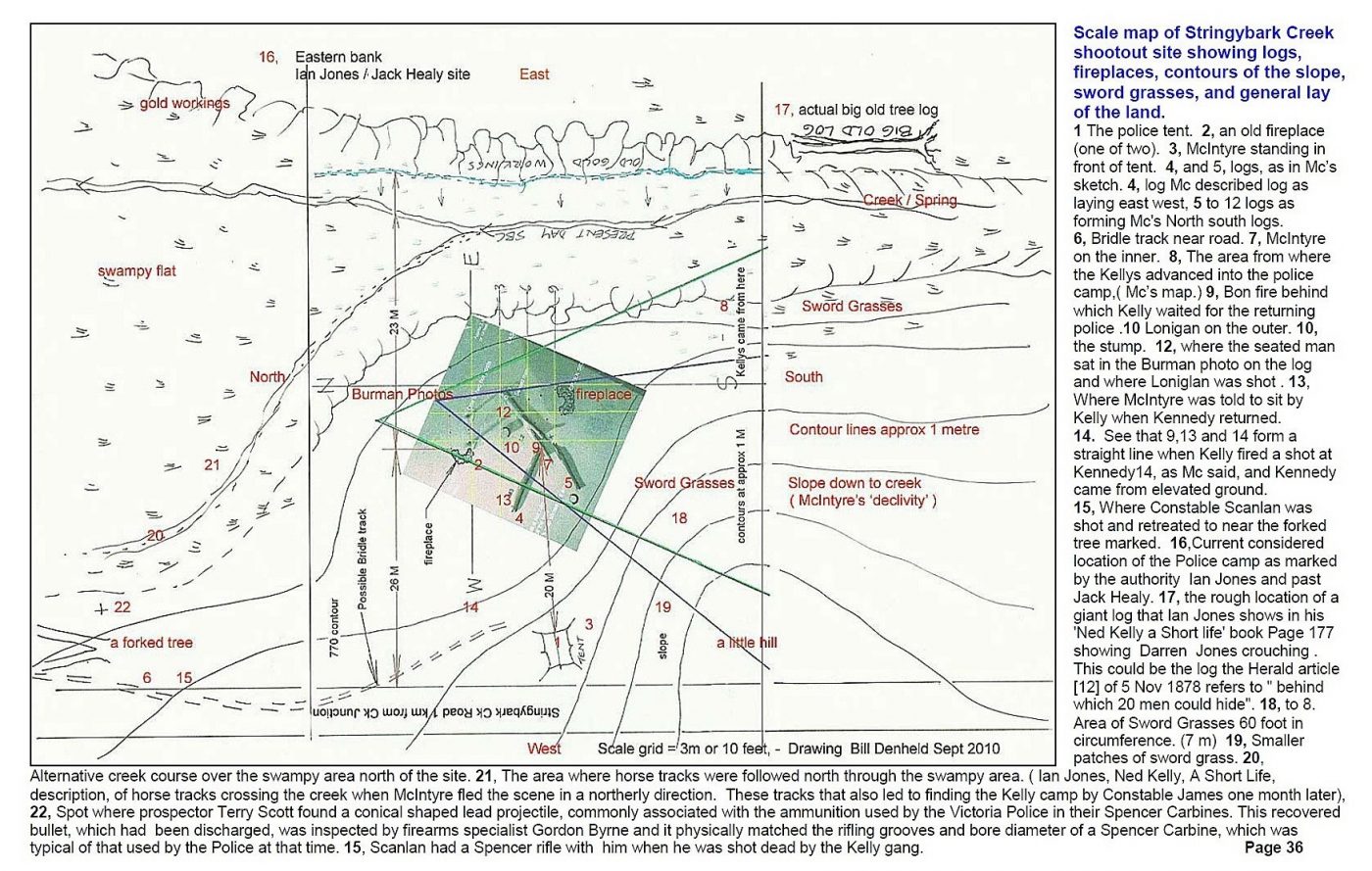
Thanks Bill, much appreciated
Bill is there a reason why this diagram is orientated with north to the left? Its coventional for north to be UP and south, down. I think it would assist interpretation and understanding if you swung it round 90 degrees! But its a great diagram!
Bill’s map shows why the Ian Jones site is definitively ruled out. Jones had the camp on the east side of the creek; but from the Herald article it is clear that the campsite was to the west of the creek. So that’s one contender down.
Hi David, The reason north is to the left is because its a page out of my document which is in landscape format, Its easy enough to turn a book around, but here is the same map North Up.
Attachment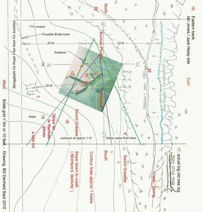
Hi all, just to go out on a limb here, I have been fascinated all afternoon by the Herald article, the Burman photos, and the McIntyre map. The first thing that stands out is that the camera position is different in the two photos. In the postcard that McIntyre spoke of, known as Burman Photo 1, there is only one hut post showing, and the actors are placed relatively close together. McIntyre said that this photo was taken from the bottom left hand corner of his map. I have attached a scan of his map, with a possible camera location lined in red, and the three men – NK, McIntyre, and a Trooper, also shown in red. I have used a camera view angle of 70 degrees to show how the positioning of the actors might work with the camera placed at the bottom left corner of his map. Note that McIntyre did not says anything else that we know of about that photo, or about the positioning of the actors. He just said that was the place, and from where it was photographed. If that is about right the camera would be looking NNE for that photo.
McMemony 2001: 90, who appears to be describing Burman photo 2, the more panoramic landscape photo with two posts, says that “the plate is taken from where the police pitched their tent next to a ruined shingle hut (only the burnt posts remain”. This shows the actors representing NK and McIntyre in the same positions as for photo 1, but the Trooper is further back with much more of the second log showing. I have drawn blue lines and circles showing where the camera might have been positioned by the tent site, again using a 70 degree camera view angle, to show where the actors might have stood for this wider landscape photo. In this case, the camera would be looking roughly NE.
It is clear that the positions of the actors do not match those drawn on by McIntyre on his detailed map. But, the place where Actor McIntyre is sitting is about right for McIntyre’s position M3, the place “McIntyre sat upon the log as ordered by Ned Kelly”, while waiting for the return of the other two troopers (see map annotation on the full original).
The place where Actor NK is sheltering close to Actor McIntyre is not from any of the McIntyre map markings, and has been likely done for effect, based on the fact that he was closely covered by NK while waiting. The position of the Trooper is inside the two fallen logs, close to where McIntyre was talking to NK in the place marked M2 by McIntyre on his map.
It may be that Burman used the known proximity of NK2 and McIntyre 2, which took place across the N-S log as marked by him in the sketch, to pose the representation of their proximity across the other E-W log at location M3, regardless that that positioning never occurred. It still conveys the drama of events at the approach of one of the troopers.
There is a further problem: the cameras in both cases would be facing NNE and NE respectively, and so the actual advance of troopers Scanlan and Kennedy would be from the north, over the other side of the logs where the camera would not see them from these positions. In that case in these photos, NK and McIntyre as posed are both facing SSE, not north, from where the troopers actually came. And the trooper is advancing from the east. But is that such a problem? The Herald article says that “Lonigan was coming up the easterly slope of the hill from the little creek” just before the attack. So at some point a trooper did rise from the east… And what a great photo it all made.
In this speculative offering I have attempted to reconcile the photos with some of what has been said about them by both McIntyre and the Herald journalist. Burman was a commercial photographer who was there to take photos that would make money. He wanted to portray the scene of the murders, and unquestionably did so, as we have a range of comments by the Herald journalist that corroborate the distances from the sword grass to the tent, the fireplace, and other points of note. The ground was clearly uneven and encompassed a long slope from the top of which the police camp could be surveyed by the attackers sheltered by spear grass. The ground appears to have had several rises, both from the creek and from the north; and there is no reason to assume it rose evenly at any particular point.
Could it be that the Burman photos were taken from the places I have sketched on the attached McIntyre map, as stated by McIntyre in respect of photo 1 (the trial postcard), and the photo 2 landscape Carte de Visite as discussed by McMenomy, from the tent site?
Attachment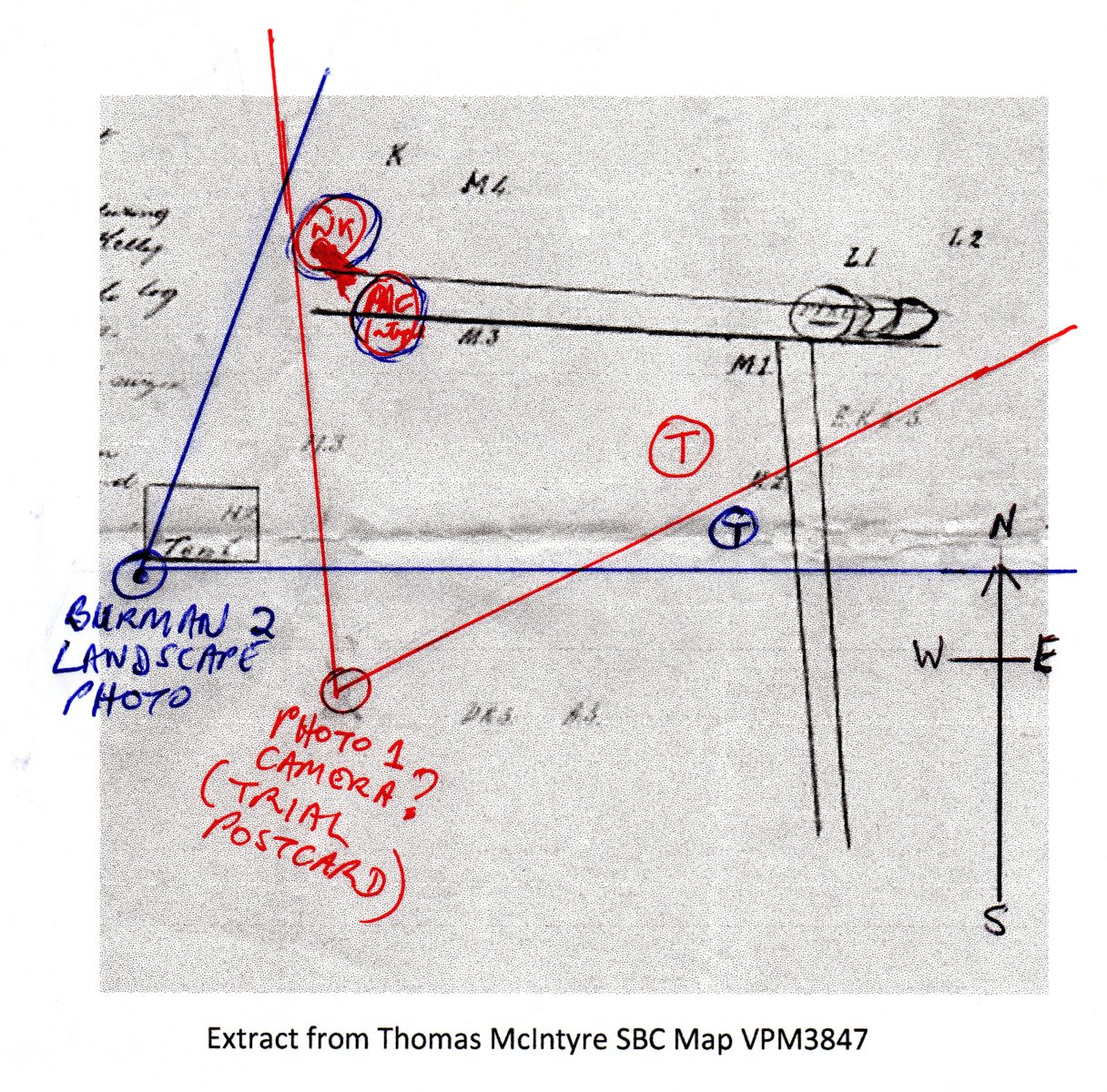
I think Bill will be able to answer this better than I can Stuart but what Mcintyres statement about where the photo was taken from means that Burman positioned all his stand-ins in the wrong places. Either that or McIntyre was wrong about where the photo was taken from. One of them got something wrong and it could easily have been either of them.
To try to sort that out I think Bills analysis of where the shadows fall indicates that the photo was taken looking to the SSW or thereabouts – meaning it was McIntyre who got it wrong. The KTG analysis agrees with Bill but the CSI and Adam Fords doesnt! But if it could be shown you were right then Bills site and the KTG site would have to be scrubbed!
I’m happy with Bills analysis!
Stuart, Of course you raise interesting issues with McIntyre’s maps the same way dozens of other researchers had done on various forums dating back to KC-2003, 2009 and in 2014 when Dee hosted the ‘Ned Kelly Truth forum’. The group then called themselves the CSI team were trying to convince the authorities of their Kelly tree site much the same way as the KTG team are doing today using pseudo science.
Readers can view Dee’s forum pages No1 to 22 here –
Ref -http://www.ironicon.com.au/sbc-dee-bate/page4.htm
where I first posted this image
https://www.ironicon.com.au/images/mcintyre-map-corrected.jpg
Attachment
Hi David, I don’t have a problem with the idea that the actors in the photos are positioned incorrectly, for two reasons. First, they don’t accord with McIntyre’s map. Second, during the court case the postcard “Exhibit A” had a note pinned to it reading – “ Doubts as to the accuracy of the scene (leading to reconstructions) perhaps been stimulated by a sense that this is a fairly unusual piece of evidence to Introduce”. ( Source: Prosecution file VPHU accompanying the Post Card – citation PROV Burman photo -0030-010-001- VPRS 4966 Consignment P0 Unit 2 Item 30 Record 1 Document: Photo of Wombat Ranges where troopers were shot. )
There is no compelling reason why McIntyre should not have located himself at M3 in his sketch sitting “upon the log as ordered by Ned Kelly”, on the south side of the log as shown in his sketch, then later swung north over the log when he seized the horse at M4. His sketch marks his location, and that of the others, at various times and positions, all identified in his map legend. It is not a slice of time thing, but shows the main movements over time.
None of this says anything about the location and topography of the site. That is far too technical for me. Having walked around the general SBC area a few years ago, mostly above and behind the current picnic area, it is clear that ground levels and slopes can vary widely across quite short distances depending on where one is. I would not like to be trying to figure out how any particular spot was the correct site. But Bill has presented a lot of material about the “two huts” location which seems to have been ignored by others.
I’m not at all sure that the possible camera positions that I experimented with in my previous sketch on the McIntyre map extract would count against his site simply because of the position of the actors in these photos.
I realise that is a case of wanting to have my cake and eat it too, but I think it more likely that Burman has positioned his actors for a dramatic illustrative photo based on parts of what he had read and was also told at the site about the encounter, than that McIntyre and the Herald journalist got key points of the site wrong, including descriptions and orientations.
Some other points about the photos :
If the photos are taken in the direction you suggest, then somewhere between the logs and the slope at the back is Stringybark Creek – but I see no indication of it anywhere, do you?
Secondly, when McIntyre was ordered to sit on the log, nobody could be certain if Kennedy and Scanlan were even going to return that night, let alone what direction they would re-enter the camp from , so it may well be, as shown in his map, that McIntyre was sitting on the other side of the log to the one shown in the Burman mock-up. However, no doubt McIntyre and the Gang would all have adopted different positions once they heard the others returning from the north, which is what is portrayed in the photographs.
I seem to also recall that the photos were claimed to show the location of Lonigan’s death – which wouldn’t be seen in photos taken looking NNE as his body lay on the other side of the logs.
And lastly that large stump in the foreground – Bill will know for sure but I think theres a description somewhere of Lonigan’s body being near it or related to it in someway, and therefore the foreground where the stump and the two posts are can only be on the northern side of the big logs, again suggesting the photo was taken looking SSW.
M3 Where McIntyre sat upon the log as ordered by E. Kelly. McIntyre’s statement before W.Foster. P.M. Beechworth. 11th August 1880. To Mr Gaunston. Reference .… Page 438 Edward “Ned” Kelly The Historical Record. Kelvyn Gill.
“(Witness here describes by diagram the arrival of Kennedy and Scanlan) I was sitting on the log with my back towards Kennedy when he was coming up. I addressed him first when about six or eight yards away. The accused then was about ten or twelve yards at my right rear.”
Hi David, it has perplexed many people for decades, and I’m not claiming to be able to solve it.
But first, the creek my wind somewhere down the back (north) in my tentative photo direction, but the Herald also says Lonigan came up the easterly slope of the hill from the little creek; and later, that both McIntyre and Kennedy evidently made off in the direction Kennedy had come into camp, because to turn right would lead into the creek. That would be east going by the photo as discussed here. The slope rose towards the summit, “receding again to the creek which winds partially round it”. So possibly a place with a very windy, bendy bit of creek around it?
Second, the photos as discussed here don’t position the Trooper arriving from the north but from the east. It may have been simply posed for the photo.
Third, the camp site is of course the scene of Lonigan’s death, but his position is not shown by an actor. On McIntyre’s map he was on the far side of the logs when shot, at L1 and died at L2. The photo is framed for the arrival of the returning troopers, after Lonigan’s death.
Fourth, as above, we don’t know what other stumps might be around there so I don’t have an answer.
If it is possible to geo-plot the two posts of the burned out hut, it might be possible to see their location in relation to how the creek winds around there. Apart from that, I’m out of ideas.
Stuart, If you are standing on the western bank of SBC looking north, on your right the ground drops off to the creek. What the reporter wrote- Lonigan came into the scene up the east slope from down near the creek side, up onto the flat ‘raised’ level on which the huts were and tent pitched. I don’t see this as an issue because the reporter was not a witness- he probably surmised what he was told and believed. Lonigan as far as I understood by what McIntyre said- Lonigan was between the two outer logs (from Mc) with his head down, and had he raised his head he would have seen the four men coming in with Bailup. So, even the reporter made a statements contradicting McIntyre, who may have bent the truth later to make it sound like Lonigan only reached for his gun when shot, whereas Lonigan may have been near the creek at that moment and made it to the logs with gun drawn ready to fire when Kelly shot him.
On my previous post with picture of
https://www.ironicon.com.au/images/mcintyre-map-corrected.jpg
Please refer this image to my scale map and you will see how Mc got it all wrong.
Attachment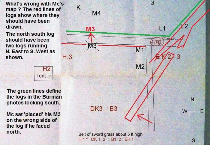
Here is another map I had prepared for Leo Kennedy who wanted to know how McIntyre’s later map fitted on the site at the two huts.
McIntyre simply drew his LATER blue map thinking the Burman photo was taken from near their tent. By making that statement in court he managed to DUD Ned’s chance to explain from where they, the four men had come in from the south. It was not an ambush.
With McIntyre’s mis orientation of the Burman photo, the post card presented by Ned’s lawyer, – the magistrate got confused, and he dismissed Ned’s Burman post card and instead believed McIntyre’s view of the photo as a direct contradiction because he was a police constable. In my opinion that’s how the law went against a fair trial for Ned Kelly and that’s how they put him away. It remains a fundamental flaw in Kellys trial.
Stuart this is an important point and with your interest to wanting to pull McIntyre’s account apart on these issues like you have done with other parts of the Kelly story, re ‘Redeeming Fitzpatrick’, and Such is Life, but McIntyre was probably quite happy to have everyone believe his story which sent Ned to the gallows.
Stuart, would you like to see how I came up with the layout of the logs, I can upload some images why its a Y.
Mc’s Map at Two Huts site-
https://www.ironicon.com.au/images/mcintyres-map-at-sbc-2-huts.jpg
Attachment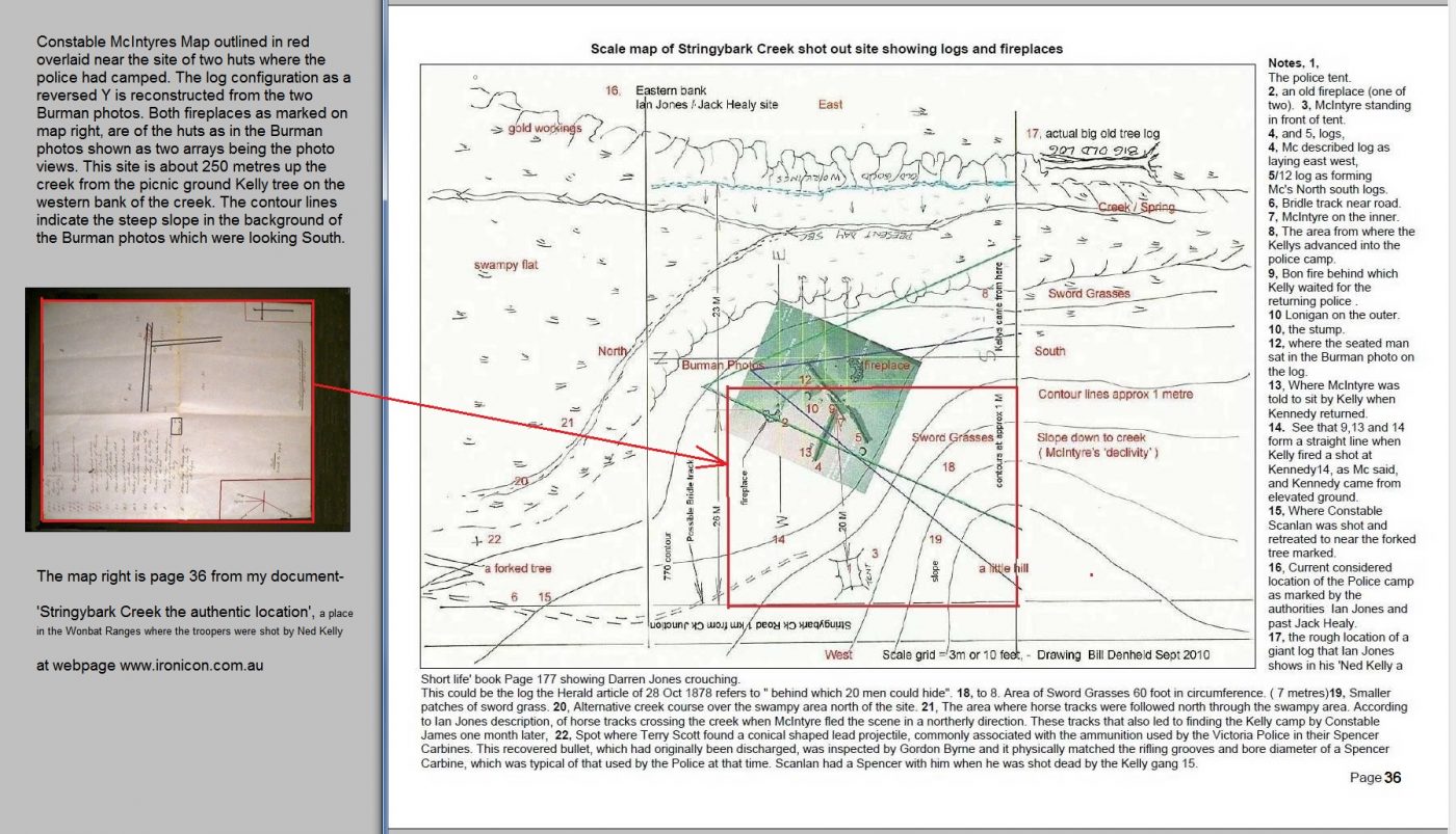
Hi Bill, yes, thanks very much for these latest images. It will take me a while to play around with all this. I realise that many people done work on this for years, but I had never known about the Herald article and always get excited when I see a new primary source!
I still have no idea how much weight any discussion about the location itself might have had or not had in relation to McIntyre’s statements about what happened, or how much weight the photo might have had if any. It is all interesting stuff to pour into the mix and see what happens.
Stuart and all, to establish how the logs formed a back to front Y, here is an early model reconstruction. The model logs were crafted to have similar shape. With the photo set up on a flat board, the model logs were arranged so as to match as closely as possible the photo, including the two posts and stump. Then when viewed from above there is not a right angle or anything like McIntyre had drawn.
The distance between the two posts put a scale to the layout grid at 3 metres.
Attachment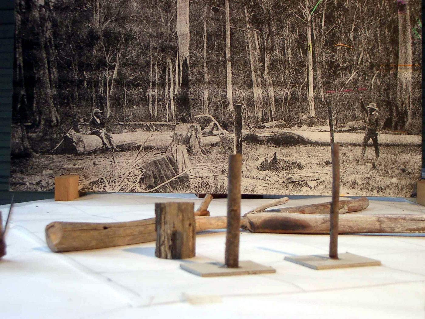
Thanks Bill, it’s all very intriguing.
We seem to be having two discussions here-
With respect to the topic of discussion, “who should we believe” I’d go for the eye witness.
I think I have demonstrated the KTGroup seized upon a flimsy detail in a digitally crunched image as being totally believable. To end their Post and Rail nonsense, here is the close up Raster image of the area where they say a post and rail fence can be seen- but there is none.
http://www.ironicon.com.au/images/09-Burman1-800-close-up.jpg
Attachment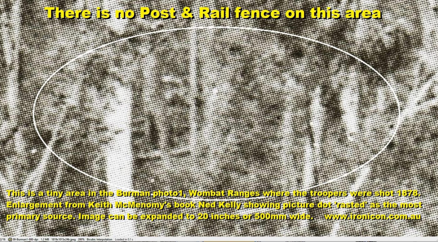
Billy please stop misleading people as you continue to do.
Unfortunately for you I have Keith McMenomys book as well and have also looked at no.1 and no2 photos on page 90 many times.Please members forget the photo above that Bill has posted if you want to know the actual truth because Bills example isn’t clear at all.You have proved absolutely nothing with that shot at all Bill.
If you look at the same photo number 1 above the one with the green markings on Davids main body of the post you will see the fence or should I say fences. They are slightly left of the raised mans gun and they ARE there Bill despite what you say.
Bob
No Bob, you’re wrong. Theres no longer any doubt about it : youre definitely wrong.
What you’re looking at are several saplings fallen across a slope, that create a superficial impression of some rather haphazard fences that start and end nowhere in particular.
The reason we can be confident that they aren’t fences is because an eyewitness went to the scene of the murders just a few days after, and wrote a very comprehensive report for the Melbourne Herald, published on November 5th 1878, as I referred to in the body of this post, above, and he stated quite clearly that no fences were erected there. Thats ZERO fences Bob. None.
The KTG proponents however, as we have seen, will never admit theyve got this wrong. Instead as I mentioned above they’ve engaged in the most absurd denialist verbal gymnastics to maintain a position that the evidence now makes completely untenable.
The huge problem they have is that if they accept what the eyewitness said about fences – and theres absolutely no reason why everyone shouldnt accept it – then they will have to accept the eyewitness description of a slope rising up behind the tent, which is something else the KTG have got wrong. They say the slope is 70m away.
Theres no way their site is the right place Bob. It doesnt match the photos or the eyewitness reports.
When all the maps have been digested; and all the archival documents and media reports regurgitated and disected – it will be found that Bill Denheld has been right about the Police Camp site all along – for YEARS and YEARS!.
Anyone who has been to his two huts site with Bill, including me and wife, Prof Tim Flannery and John Doyle, and many heaps of others, have been convinced Bill is spot-on.
It is when he finishes his talk and produces his blown-up Burman photo, there in the background is the identical slope as shown in the Burman photo. I didn’t say the trees are absolutely identical, but the slope is!
There are no ifs and buts about this. It is time Bill’s site was acknowledged and accepted. As you point out David, KTG and CSI sites lack background slopes. They are of course 100% wrong.
Only Bill’s site has the i d e n t i c a l Burman slope in the background.
I hereby declare that Bill found the Police Camp site years ago. His is the obvious, correct site…
Prove me wrong…..!
Ian MacFarlane
Hi all, this might be stating the obvious but the Herald report of the site does not say anything about the direction from which the Burman photos were taken, as the Herald writer speaks of their party wandering around the site including inspecting “the pile of logs on which McIntyre sat while the murderers waited the coming of Kennedy and Scanlan”. He then picked up some leaves and feathers and headed off, “leaving Mr Burman to photograph the various scenes”. Burman was free to compose as he saw fit. But it is clear from this that Burman had the right spot and group of fallen trees. The Herald descriptions of the sword grass and the orientation from which the gang emerged seem consistent with McIntyre’s descriptions of the site as per his map. It is easy to see why there has been so much debate about this stuff over the years.
“Prove me wrong” Indeed that’s easy.
Just spend some time doing a detailed analysis of the CSI groups work which has been previously published and includes analysis of topographical layout (btw matches the Herald reporters description) location of the speargrass (which can STILL BE SEEN TODAY), the spring on rising ground also visible today (and close to the suggested police camp), the distance of the camp as per McIntyre’s derscription at 70 yards from the creek, the identification of a young manna gum in the left rear of the Mr Cuddon photograph, rising ground to the east – ie a slope!!, the location of the remains of a hut site (NOT a BBQ as suggested by BD) , the survey information clearly shows the “northern slope of the hill” on which the “police tent was pitched”, the sun’s traverse of the area detailed in one of the reports appendices provides all the info necessary to work out shadows seen in the Burman pics and so enabling the direction of the camera image.
I could go on as the excellent CSI report has much more to consider.
If you haven’t read it it is in the Melbourne state library and may still be available up at the souvenir shop in Glenrowan.
Oh and the amazement of the “discovery” of the 5 Nov 1878 Herald report – it was included by the CSI team in their first report of 2012!! and referenced extensively by them.
Good on the CSI work, its the best done by far to show the place where the police were murdered.
Well I really was starting to wonder if the CSI site had been completely abandoned!
Their report is an interesting read and full of information, including appendix 15 which was the full report from the Herald of November 5th 1878 – the ‘amazement’ was not to discover the Report, but to notice something in it that had never been commented on before, to my knowledge at least, that “no fencing was erected”. The anonymous KTG spokespersons desperate attempt to explain away this very clear statement, and cling to their interpretation that post-and-rail fences are seen was rather sad, and made even sadder when they posted a Sketcher drawing of the scene that had no fences and no teapot tree branch and the starburst tree at the front edge of the adjacent bush – the opposite of what they claim. I’m afraid they’re in serious denial.
The KTG refuse to even discuss that eyewitness account that says the tent was on the beginning of the slope and the slope continued from the rear of the tent up to its summit.That eyewitness report demolished their belief in the slope being a photographic illusion, and their claim of a 70 yard flat extending back to the ‘fences’ and the starburst tree.
The CSI’s ‘burl tree’ and the KTGs Teapot tree are several hundred metres apart, but are supposed to be the same tree. I wonder if the CSI team are going to defend their claim against the KTGs claim – they cant both be right, but they can definitely both be wrong – which is my belief, as both teams arguments rely on very weak if any verifiable evidence.
Another point of serious difference between the CSI and the KTG claims is their belief about the direction the camera was pointing when Burman took his photos. I agree with the result of Bills investigation, as do the KTG, but the CSI has the camera pointing east and north east – which as I’ve argued before means Burman mock-up was all wrong. That could mean that his Kennedy tree mock up was all wrong too – it may have been any convenient tree, given the CSI belief he wasn’t all that interested in accuracy. I dont share that belief – I think he tried to make it as accurate as possible but was limited by the technology – and so squeezed everyone in to the middle to get a more informative shot.
But lots of this is opinion – something the KTG dont accept is what theyre advancing also – and my position is based on what I think are the most sensible answers to all the many little puzzles which have to be fitted together to get an insight into what happened where.
The KTG on the other hand think they’ve solved the puzzle, all their interpretations are the correct ones and everyone else can go back to their drawing boards. Their dogmatism is already proving to be their undoing in my opinion.
Ah well, I suppose, if CSI has the camera pointing east and north east – and if that is right – then Burman’s mock-up was wrong as you say, and also as shown by the positioning of persons in McIntyre’s map. But not necessarily fatally, unless you assume that commercial photographer Burman was actually trying to do forensically accurate photographs rather than sellable photos. We know that is not the case, as his two “McIntyre seated” photos were taken from different places, with the Trooper moved over in accordance with pictoral requirements. I may have to track down the CSI report, although it’s a mystery why they haven’t put it online by now. But there is a prior question before going off to read that, which is how much weight the postcard photo had in Kelly’s committal trial and everything that was said about it. It may or may not have any actual importance in the trial context; and then the question is, does that mean there is any importance about the particular site it shows in relation to the other testimony and statements. Maybe it’s just a tangential side issue. I had never thought of the photo in court issue having any importance at all. Back to the drawing board for another think…
Anonymous says there is “a slope” at the CSI site. If it is not the identical Burman slope (as can be clearly seen at Bill’s site), CSI were wrong.
Ian MacFarlane
Hello Ian, it really amazes me that since we all went down this road so long ago we still have bods out there trying to prove the impossible. I knew I had a few images that made the point about the CSI site looking N East, and here is one typical. It was put on a forum by Glenn Standing of the CSI team saying the east bank slope was strong. The problem being that if they said the Kelly tree is in the Burman photo ! , then we need a bit of flat ground on which to place the logs in foreground with two huts- then the slope in the background, then tree line sky. In the attached photo you can see the height of the slope by the red line, but it should be up near the white line if it had any credibility, -dividing the photo into three = parts, and considering there should be no creek between foreground and slope.
http://www.denheldid.com/twohuts/images/glennsslopeatktree.jpg
Attachment
So Ian mac the only response you can make to the observations quoted by anonymous is to to say its “not the identical Burman slope”. A pathetic response completely ignoring the other matters. Why?? My guess is because you cannot rebut clearly made claims/observations of the CSI team. If that’s all you’ve got you can be assigned to the history dustbin along with some others.
I have read and reread the CSI report, visited the area in dispute on my last trip to your wonderful country with the CSI report firmly clasped and looked at many times whilst walking around (something I guess you haven’t done either other than be beguiled by Mr Denheld and his fanciful myopic claim).
So I have one more pertinent matter which the CSI team gave comment about and included a full appendix too – it’s the photo called “Beautiful Mansfield “ Booklet Photograph made by Henry J Vallance (its at the SLV and referenced by RARELT 99.5 V66 number vp 1296) made in 1897 and which clearly shows a cleared area with a backdrop of some trees and in the far distance a hilltop which is identified in an accompanying topographic map extract whitfield 8124-S. 1:50000 and its direction indicated from where the photograph was made.
Seems this is yet another piece of historical importance conveniently ignored by all except the CSI team.
THerre can be no doubt after many readings of an excellent detailed study which no other claimants have ever done that they have nailed the general area in which the police suffered at the hands of a bloodthirsty band of desperadoes.
Anonymous what’s with the vitriol?
And we have debated the CSI site here before so can I ask that we keep this thread to the topic on hand which is the KTG claim.
The question was who should we believe, the eyewitness or the KTG?
What amazes me is how many former CSI supporters prefer the hopeful speculations of the KTG to an eyewitness report. And how swiftly they’ve jumped camp.
Anonymouse,
What part of the word identical don’t you get?
Identical means exactly the same.
One-sided “debate” with the CSI team has been endless, boring and time-wasting. Who can forget the Forum started by David where the CSI people quarreled everyday with us about aspects of their ‘findings’ which led exactly nowhere.
Ian MacFarlane
Really?
What other matters are there?
Ian MacFarlane
For those wanting to read the CSI report I have a copy of the pertinent pages here-
http://www.ironicon.com.au/csi-at-sbc-2017.htm |
I have been adding a few notes to some images I had made long ago but never shown.
The image tells a lot more than words.
Attachment
Hello all, David, anonymouse as he has spelt his post ID -maybe rat, but every body is entitled to their privacy and can splurge out anything they want to defend their half baked scenario.
Anyway, here is another image the Kennedy Tree team of experts and their followers need to address. Specifically, their scenario having identified a police camp 2.6 times the size of where the police had camped, its like comparing a tennis court to a football field. The trees they have photographed and marked as PC1, 2, 3 and (drum roll) drrrrm drrrm drrrm. PC4 may as well be over the ridge as far away as no PC4 can be seen in the Burman photos, that’s why I did not even make mention of it in my model layout, because it does not apply.
Attachment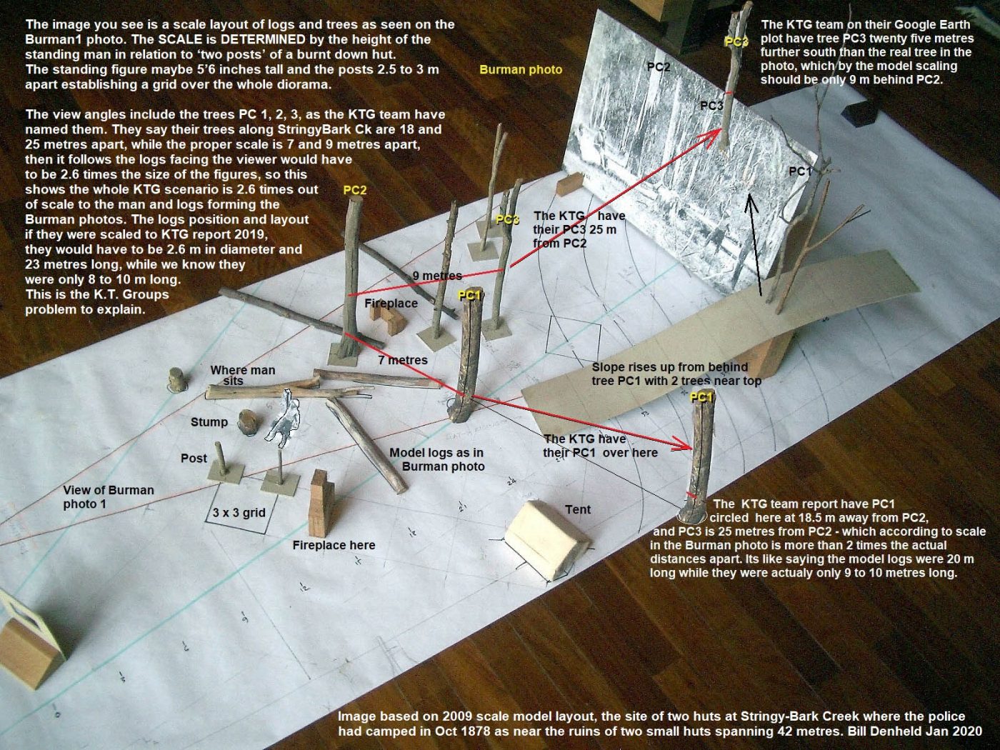
McIntyre
There was some tall spear grass at the south side of the open space. It was about 35yrds from the fire where we were standing and about 5ft high or quite enough to hide persons.
These together with a slight declivity in the formation in that direction afforded good cover to within 20yrds of our tent for any party wishing to attack our camp, and it was from this position we were attacked, the south side or up the creek. The four men were in a line and two or three yards distant from each other and all the same distance about 40yards from us.
When the man on the right fired at Lonigan he was about 40yrds distant from him.
Reporter.
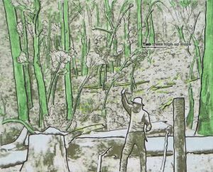
“At the top of the slope and overlooking the police tent, was a clump of scrub and sword-grass, some sixty feet in circumference, and in which a dozen men could readily conceal themselves.
Standing a few feet in front of this clump of scrub but still overlooking the police tent, are two bunches of sword-grass, four feet six inches high, and presenting a covering surface of some six feet. It was from behind these bunches of sword-grass that Kelly and his confederates called on the police to surrender.”
“At the time the call to surrender was made, M’Intyre was at the fire cooking. This was precisely 39 paces from the foremost bunches of grass. The tent stood exactly 25 paces from the Kelly’s hiding place.”
1 pace = approx. 1 yrd. 39 & 25yrds (or 35 & 22 mtrs) Two Intersecting lines. 35mtrs from the fire, 22mtrs from the tent. Placing the foremost bunches of sword grass high up on the slope near or on the road. It would be from near this position that Kelly shot Lonigan. About 39/40yrds from where Lonigan and McIntyre were standing near the fire.
If Kelly shot Lonigan from the direction of the creek then he would not be overlooking the tent. (http://www.ironicon.com.au/images/SBC36.jpg)
Some food for thought: From An Observer.
To Bill I don’t see any half baked scenario being made by anonymouse. Perhaps the anonyrat is trying to inject some more very relevant material into this debate about the Kennedy tree Group and their claim to a site they say is the proper place. The photo to which anonyrat refers is I think the only one taken within the intervening 20 years from it to the police shootings; and if so in the words of another prolific poster of models and hypothesis should be seen as Primary evidence to be compared to that groups claims that trees maketh the answer. There are two trees clear in this photo so no doubt they can be related to those of the groups miraculous finds or if not why not.
It is also interesting (to me at least) that the research presented by the CSI team is simply ignored and never fully rebutted which have been mentioned in the anonymous posting of January 2, (their topographical layout from survey results, speargrass observations, the finding of a spring close to their proposed site (unlike the Kennedy tree peoples spring so far away from their trees) I am of the opinion all of which demand consideration or rebuttal by the protagonists in this eternal ever consuming toing and froing. Perhaps because no grounds can be conjured up or better still no realistic rebuttal can be made, then the CSI teams results remain to speak for themselves and I would also suggest making them overall winner in the find the campsite competition which has now been running for a hell of a long time.
PS my copy of the CSI stuff was purchased about 7 years ago at the Cobb and Co shop in Glenrowan so just as anonymouse has had a lot of time to deliberate on the matter so too have I and I takes me hat off to the anonymouser.
And as for the vitriol espoused by the anonymouse David, there wasn’t any as all that was said was factual in my opinion.
at
To the Pseudo Anonyrodent – great name by the way – you claim the CSI teams report has been ignored and ‘never fully rebutted’ . Can I suggest you go to the top of this page and enter “CSI” in the search space beside the magnifying glass . This will then provide you with a list of about six or more Posts which are all about the CSI reports, and more than refute your suggestion the CSI report has been ignored and never rebutted.
Heres a link to the first one, which I wrote in 2016:
http://nedkellyunmasked.com/2016/09/the-csi-sbc-report-is-pseudo-science/
I am leaving the front and back of the Burman 1 photo. The back shows it was used in a Magistrate’s court and was intended for use in Reg v. Edward Kelly.
Ian MacFarlane
Attachment
I could only upload one pic at a time. So here is the second pic.
Ian MacFarlane
Attachment
“The Board noted the repeated use of the phrase ‘Ship Creek’ and considered that while this does emphasise the reference to ‘shit creek’ in the Board’s view the overall tone is light-hearted and humorous and the language used is not inapproprias alsoste in the circumstances and does not amount to strong or obscene language,” it decided.
The SCI@SBC report is also light-hearted and humorous…
Hello Ian,
Its amazing these post cards still exist. Obviously the image is quite poor probably due to paper acid decay of the chemistry used to fix the photo. Because the post card was publicly available it was of use to show they four men came into the camp together and did not ambush. McIntyre’s own sketch showed the men together in a row, but Kelly was not believed from where they came , and they believed McIntyre’s version of the photo taken looking North east. In 2002 after speaking to Ian Jones I had prepared this sketch for him to approve of, he said he did not do email so I printed this image with a letter and posted it to him with explanation how I arrived at the grid and layout. He was angered because in his book with drawings by John Ward, they had a X crossed set of logs and I a Y set of logs.
This sketch was what I had sent Ian Jones but he never replied.
Ian Mc, it is really good to see you on this page, thanks for your involvement in helping to wizen the reader to the truth of sites and history. I know that after all your research you did not like Ned very much, but to every story there are two sides pro and con.
Attachment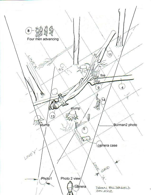
Bill, the Burman photographs at Public Record Office Victoria seemed to be in quite good condition when I last saw them. To me they seemed good quality pictures of that time period. They were prints rather than the originals, of course. By today’s standards, as you and David have pointed out, they lack the clarity we expect today.
But you both have shown that, even so, vital details still can be gleaned from them today.
Ian MacFarlane
I would have thought that MR MacF (I assume no relation to you David) would have taken the time to get his facts right given he has previously been lauded and defended by people enamored with his book fanciful titled the Kelly gang unmasked (with errors of fact therein) and defended as a reputedly fine author to boot.
I am using my copy of the csi report to rebut the comment that the back of No 1 photo was used in a Magistrate’s court etc etc.
It was in fact tendered (not intended) as the Crown’s exhibit A at Ned’s murder trial in the Melbourne Supreme Court (hardly a Magistrates one!) and it was commented on by Judge Barry in his notes that the Photograph of the place (was) produced. The Judges notes can be found in the records office with the reference of 4966/2/4/record 15.
Thanks David for your reminder that you did review the csi report. A lone voice if I recall apart from that serial scribe and model maker extrordinaire.
And your kind words that my choice of Pseudo Anonyrodent was a pretty good one.
I’m not aware that any stuff by you seems to have made any difference to what I would suggest is a tacit concurrence by the authorities who have spent the money setting up the story panels at Stringybark.
The words in one of the panels near to todays Kelly tree says it all
” Since the day the tragedy occurred at Stringybark Creek, there has been a marked tree as a locator in some form. This tree is the third tree to be marked to remember the events that occurred here.
Over time the police families have called each marked tree The Police Tree. Others have called them the Brond Tree, Lonigan Tree and commonly – The Kelly Tree.
In the absence of any official onsite recognition of the ambushes at Stringybark Creek, two trees scarred by bullets became recognised as local landmarks. One tree was located at the police camp where Constables Lonigan and Scanlon were murdered. The second tree stood a quarter of a mile away to the north west on the site where Sergeant Kennedy was killed. It was inscribed with a cross and the letter “K”. While the Kennedy tree survived until the 1920s before it was harvested, the tree at the police camp was felled in 1908. This left only the tree stump behind to mark the location.”
That stump is shown in the csi report with Harry Engelke and dog Brownie in a photo taken in 1936
PSEUDO ANONYRODENT: You seem to be quite a lot dumber than I had thought.
Beechworth Police Magistrate William Foster has signed the back of the photo and dated when it was used in his court.
I merely mentioned in my post the photo was intended for use at Ned’s trial — which was also written on the back. The photo was indeed used at Ned’s trial as my book clearly showed.
How about an apology?
Ian MacFarlane.
ps: And ditch the CSI rubbish. Noone here thinks their site is remotely likely!
And have a happy life!
To Pseudo-anonyrat : Does the SBC story panel REALLY say that the KENNEDY tree was ‘harvested’ in the 1920’s? If so, someone should tell the KTG there barking up the wrong stump.
But is there any actual evidence for this claim? If so I would love to see it.
I’m not related to David, but am very proud to share his surname of the warlike Scottish Highland clan. I doubt the clan would have had much time for the CSI@SBC gibberish.
Ian MacFarlane
Yes David my NE correspondent from the local area of Tolmie has assured me that the story board REALLY DOES say just that.
He also says that the complete text of the board is recorded in the kellycountry 2000 pages.
Its interesting perhaps that neither the Kennedy tree finders nor that Mr Denheld has noted the content which my correspondent says has been on display now for a considerable number of months.
As if!
Cam West
I just wanted to check that it really was the Kennedy Tree that was ‘harvested’ in the 1920’s.
OK so now we really DO need to know what the source is for that claim, because if its reliable, it means the KTG have some explaining to do.
I will ask them on their Facebook page – but at the rate at which they are responding to questions these days it may never be answered.
Those who have Kelvyn Gill’s two volume 2016 edition of his “Edward ‘Ned’ Kelly: The Definitive Record”, may like to have a look at the photos of the “Kelly Trees at Stringybark Creek” in Vol 2, page 1059. They show the uprooted stump of the first “Kelly tree” in 1936 with Harry Engelke. The second “Kelly tree” photo is from 1938, a tree nearby the old stump which was marked with a board by Charlie Beasley. The third “Kelly tree” – yet another tree – was carved with the police names in the 1930s by Tim Brond. I gather from Leo Kennedy’s book that it was known as the police tree, not the Kelly tree, until 1985 when a metal plaque of Kelly’s helmet replaced the names of the police. OK, this doesn’t help with the Kennedy Tree issue, but it may be relevant to this discussion about what trees are which.
I think whats important to note is that all these trees are south of the picnic ground and all the proposed locations of the police Camp Site are in that general vicinity…..
……..except for the KTG site which is way to the north.
Hello David and all,
In 2003 I was sent a bundle of photos after speaking to Charlie Engelke who grew up at top end of SBC road. Sheila Hutchinson and Charlie obviously knew each other from school days. Sheila and I were working together to solve the SBC sites when it became apparent Charlie had some photos. He sent them across from WA and I scanned them. I gave Sheila the images on disc.
One interesting image was the stump photo, but what soon became obvious, this stump was not the Kelly tree stump as Charlie had thought because the terrain, the lay of the land, and the photo did not match the area near the two huts, and the Mr Cuddon photo in front of the ‘then’ assumed Kelly tree was still standing when the stump photo was taken. This then makes a case for the stump being of the Kennedy tree assumed cut down in the 1920 as Pseudo Anon ascribes.
See letter from Charlie Engelke as attached –
Also see 2014 webpage dee bate http://www.ironicon.com.au/sbc-dee-bate/page10.htm
My warning though, 1920s is a long time after the event, so anyone marking a K tree with a cross may have been led to believe it was the tree with no proof, just as today we have the KTGroup believing they have the tree.
However, if Charlie’s knowledge of and place and photo is any guide, he suggests this stump was on the west bank between the creek and the road somewhere near the current Kelly tree. This in itself rules out the Kennedy tree as he talks about the Kelly tree. Its my suspicion the Engelke photo of Harry and stump may have been in the area the KTG now want the police camp to be.
Like David asks, what is the source of the Kennedy tree information for it to end up on signage for SBC prepared by Charles Walsh Nature Tourism, for I was never consulted, but Mansfield Historical Society member Sheila Hutchinson may know the source, but she and I spent a lot of time looking for the Kennedy site in 2004-5, but this area was proven wrong by primary sources having Sgnt Kennedy’s body found to the North East of SBC.
http://www.ironicon.com.au/images/part-of-engelke-letter.jpg
Attachment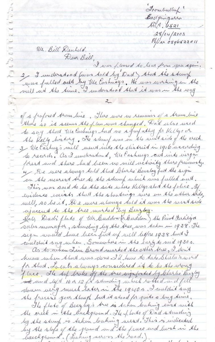
Here is photo of Harry Engelke at the stump, – with dog. If you enlarge the image you will see posts of a fence along the SBC road being on Beasley’s property. The question why this stump is on its side is hard to fathom since if the tree was cut down some 15 years earlier, why does it look so rotten in that short period of time, and why would such a large hole be dug to get it out when there appears plenty of room for a sawmill tram line, but this would not be planned on someone elses private property. If it was the stump of a ‘Kennedy tree’ then I think it was fanciful thinking on part of the locals who were convinced of the police camp site because a surveyor Gatward had placed a hut with the relevant words. Seems of all the locals, only Jack Healy knew the true site way up the creek.
Attachment
So Bill wasn’t consulted by Charles Walsh (posting of the 12th). That’s an arrogant statement -why should he be?? and Bill also then acknowledges that Charlie Engleke says that the stump was on the west bank (nothing new here as this had been established years ago) between the creek and the road somewhere near the current Kelly tree (that is very consistent with the story board wording discussed in earlier posts) but to then try and move the stump (metaphorically speaking) by a suspicion that it may have been in the area the KTG now want the police camp to be in is simply a nonsensical suspicion which is a technique used to throw the reader from considering that in fact the CSI work further enforces the positioning of the police camp in the vicinity of the Kelly tree and not anywhere near to the two fireplaces many metres further south from this area. Then to try and relate the Engleke stump in any way with the Kennedy tree is just more obfuscation. And to say that the Engleke stump was not the Kelly tree because the terrain, the lay of the land, and the photo (in which the terrain and land lay out are shown naturally!) did not match the area near the two huts is more hubris!! OF COURSE NOT AS THE TREE STUMP IS NEAR TO THE AREA DESCRIBED IN THE STORY BOARD.
Bad luck Bill this is just another example of how wrong two fireplaces make the correct site according to you.
Hell o K’, I did have the pleasure of in depth discussion with Mr Walsh and what became quite obvious, the ‘pending signage’ planned for SBC was far more politically aligned than historical. I said, so’ you have been given permission to tell lies ? He said its only about the sense of place, and people will believe what they want.
The attached image comes from Dr James Maxlow, his talk on ‘Global Expansion Tectonics’ presented at the Nexus Conference 2010.
Attachment
My understanding is that for the site of the two fireplaces to be that of the police camp:
McIntyre’s detailed drawing of the logs is wrong.
The locations he showed in the drawing of the Kelly’s when they first bailed up the police are wrong.
The direction he said that the photo was taken from is wrong.
His distance of 70yrds from the tent to the creek is wrong as maybe he meant feet (23yrds) or a typo error.
The early surveyor maps showing the site to be much further north of the two fireplaces are not relevant.
The Cuddon photo of the second marked tree said to be nearby the stump of the first Kelly tree was in the wrong location.
(As a local man showed no respect and did not want people traipsing over his land so randomly marked a tree)
The photo of Harry Engelke next to original Kelly tree stump does not match the location of the Two Hut site so that is wrong.
Seems all of the locals were wrong with the exception of Jack Healy who was said to have led Ian Jones to another true site that was also wrong.
Nothing will change while people keep on arguing and defending their beliefs until their blue in the face.
The nastiness all of this has brought out in people with a common interest in the Kelly story is not just sad but a disgrace.
Little wonder Mr Walsh was left saying that it’s about the sense of the place and people will believe what they want.
Now for a read about ‘Global Expansion Tectonics’ …….. riveting.
Can we PLEASE discuss the KTG proposal instead of wandering off into the old debates about the CSI Site vs the Two huts site? Once we have reached a consensus about the KTG site then maybe we can go back to those arguments – yet again – but could we deal with this one first?
I would like to know what the pseudo Anonyrat and other anonymice think about the KTG claims, about how credible their claims about trees seen in the photos are and what chance do people think they have of persuading anyone that they are right and the Eyewitness was wrong?
David I can’t even find the KTG site – every time I google Kennedy Tree, I get JFK’s family genealogy.
Someone here pointed out that a horticulturalist is not a tree expert. A horticulturist is someone who uses scientific knowledge to cultivate and propagate plants, and then uses this knowledge to provide technical information to fruit, vegetable and flower growers as well as farmers.
KTG apparently rely on a horticulturist which severely damages their case, whatever it is.
Rebecca
Indeed Anonymous you have made many a good point. You can only see as far as you want to or perhaps expressed slightly differently you can only look but not see. This topic of the place where the police murders occurred is irrelevant, the area belongs to the memory of the slain police and this has now respectfully been marked.
RIP
James and Anita Maxlow have published Terra Non Firma Earth: Plate Tectonics Is A Myth
The author(s) uses modern geological, geophysical, and geographical evidence to challenge the misconception that plate tectonics is the key to understanding the Earth sciences. Dr James Marlow reintroduces the notion put forward by Hilgenberg in the 1930s, that the Earths radius has been increasing through time and that, if all of Earths continents were fitted together on a smaller radius Earth model, they would neatly envelop the Earth with continental crust at approximately 55 to 60% of the present Earths size. (less)
A very good example of using evidence to promulgate their hypothesis… its a good read.
Regarding the Kennedy Tree Group locations, I thought it ironic that they were doing their ‘research’ at around the same time that the ‘authorities – DELWP – with Heritage Vic – with Vic Police Historical Unit (VPHU) all settled for a fictitious place and gave Charles Walsh Nature Tourism the signage gig. Here is a question; Does anyone know how much they spent with all that signage and track creation to places where Nothing ever happened? In 2004 they spent $55K on establishing the Jones site, so I reckon the taxpayer must have been done for at least $200k this last lot. So we can see who the real Bush Rangers are !
The attached picture was prepared for Peter Fitzsimons’s 2013 Ned Kelly book, and by contrast (on the right) is what VPHU decided upon and implemented. Perhaps this was the catalyst for KTG team to seize the moment as ‘their’ place is between Nos 1 and 5, – the track arrow at 5 being- by co incidence where they say their Kennedy tree is located. Taken that Numbers 1,2,3,5,6,7 all have absolutely nothing to do with where the police camped or were killed, – makes this whole scenario a farce that considering the expenses, in the end will bit them all on the bum. Its also ironic that not long before all this, the Lawless Adam ford doco has the camp at No1 ( right image). What a perfect set up to hoodwink the un informed visiting public.
Let me take you on a tour of StringyBark Creek, sorry its a bit rough but all just off the cuff-
https://www.youtube.com/watch?v=c92pdsU97ms&t=14s
Then while you’re at it take a look at this as well- its my explanation for what KTG reckon is a post and rail fence- I called it ‘De fencing the KTG Post and Rail fence’
https://www.youtube.com/watch?v=30n4_eh1lG0
Attachment
http://www.ironicon.com.au/images/sbc-actual-place-vs-sense-of-place.jpg
Attachment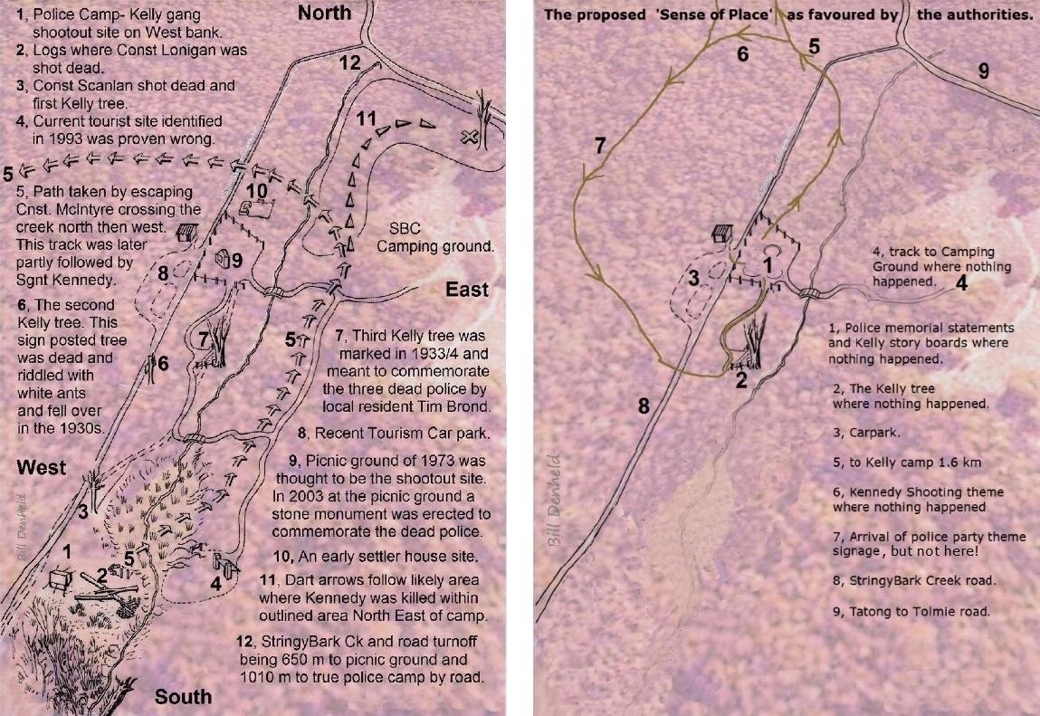
Thanks for the offer David but I have no interest in the Kennedy tree except to say that Leo Kennedy must be wondering whats going on. He says in his Black Snake book that “There was the Kennedy one, with a ‘K’ and a cross” as told to him by his father (page 261), and later at page 275 explains how he and an archaeologist rediscovered a clear patch a quarter of a mile north-west of the camp with grass tufts that appeared in the Burman photo. To within 3 metres the archaeologist said. “Found!” I (Leo) said.
So is this at the place the KTG people say the Kennedy Tree can be seen today?
Perhaps when you wade through http://www.denheldid.com/twohuts/newsupdates.htm
it will become muddier than ever.
Us rats have had enough of this you said I said and the ever incessant serial expert’s diagrams, drawings and rants. I hope from all this that the Kennedy family can find the true tree.
PS Its nearly my year, big celebrations are planned.
And I will have something to say in reply to IMcF once the celebrations are over.
“Us rats have had enough of this”!
Well, you can always smartly withdraw to avoid looking like a complete time-waster, can’t you?
We’re looking forward to your Macca apology!
Horrie and Alf
NOTICE TO ALL COMMENTATORS :
I’ve not posted several of the comments you’ve submitted over the last week because all of them contain petty personal attacks, and I really don’t think any of this is necessary. Some of the posts have also had actual points to make, and Ive been in two minds about posting them but in the end I have decided not to. These comments apply to ALL sides of the debate.
If any of you have a point you want to make about the debate on hand, which is the KTG claim to have found the police campsite, please make your point and leave out the other stuff. The it will get posted and the debate can continue.
David,
You have amply demonstrated that KTG have produced a farcical report that is incongruous, based on many glaring research faults and follies (imaginary fencing on a hill that they say didn’t exist. How does that work?)
Amateurish guesswork.
Clem
If only the KTG had visited Bill Denheld’s correct police camp site, they would have seen the exact Burman slope in the background and not wasted all our time.
Roy
Alf and I are beginning to think the KTG may have received “expert” advice from a well-known time-wasting internet serial pest and self-proclaimed Kelly expert “Sarah” (who was photographed at Bill’s two huts site a few years ago – but constantly bags Bill at every opportunity).
It’s hard to believe that a person who actually was at Bill’s site with Bill – and could clearly see the Burman rise in the background – rejects it today.
Horrie and Alf
Alf and I are watching Federer on tennis and the wacky Keith Ledger Ned movie. Federer is doing what he does best, coming back from oblivion.
Alf and I liked Heath Ledger as Ned more this time, but the movie itself is a abomination of foolish historical mistakes long disproven. FitzPatrick didn’t molest Kate. Lonigan didn’t fire at Ned as shown in the movie, nor did Scanlon get off a shot.as the movie suggests.
Terrible.
Horrie and Alf
The latest Horror and Alfie post has absolutely nothing to do with the topic and is a clear breach of the recent NOTICE TO ALL COMMENTATORS.
So Mr moderator David WHY LET IT THROUGH?
Neither Horror nor Alfie have any brains – all of the pre PR for the Kelly film has clearly said it was a concoction loosly based on Carey’s book and bears no resemblance to actual facts, also a statement in the film’s intro.
“Sarah” I let it through because my Notice was specifically aimed at petty personal attacks, and that post. although hardly relevant to the discussion on hand, didnt involve any. However it could be argued that this complaint of yours IS a petty personal attack and under the new rules I shouldn’t have allowed it through. However I have on this occasion, after removing the last sentence of insults, to make my point even more clear to all sides.
Petty personal attacks are not on, no matter who makes them, and no matter what other interesting commentary might accompany them.
David,
Still haven’t been able to access KTG site.
Re-read your blog. Looks to me as if they got it all wrong.
Ian MacFarlane
A qualified apology to you Mr MacF and a fine bit of cheese I snaffled from the rat trap with great daring would be sent to you but I haven’t been able to stuff it in any orifice on the antiquated computer I get to when the factory is closed for the night to send it to you.
Now a few words about that much discussed card of Mr Burmans.
Searching around I have not found any reference to it being presented in the Beechworth hearing; yes it is noted by police magistrate Foster with the word exhibit but that in itself does not say that any use was made of it.
I await your reply as to where any words explaining that it was presented and discussed and what was said about the portrayal therein can be found.
And yes you did mention it in your book by reference to DS Kennedys report as part of your Forensic science explanations, well before any review of the murder trial in October so it takes a leap into the abyss by readers to connect it with the trial and also under the photograph of the card you say it was used as exhibit A at Neds murder trial.
For the reader to understand the import of this card your construct of the section on Neds trial lacks any reference or use of this card – a sloppy omission I would suggest is corrected in the re release of your book (if Ian J can get his book re released so many times then I would assume that as your book has garnered high accolades ? it too will reappear with corrections and improvements.
I’ll have to go now, the morning shift have just switched on the factory lights.
Oh and try this link:
https://www.facebook.com/pg/The-Kennedy-Tree-Report-112859136806485/posts/?ref=page_internal
Anonyrat, you didn’t watch Perry Mason enough – otherwise you would know what a court exhibit is.
The Burman photo we’re discussing clearly shows it was a court exhibit A:
A
—–
Exhibit
Prosecution
Reg v Edward Kelly
Murder
6th August 1880
Constable Lonigan and Scanlan case
[signed] W Foster PM [Police Magistrate]
6/8/80
Public Record Office Victoria (the State Archives) says “This photograph taken by photographers Burman and Madeley, is one of a series of prints of what came to be known as Kelly country, it was used in Kellys trial to set the scene at Stringy Bark Creek. Later doubts as to the accuracy of the scene (leading to reconstructions) perhaps been stimulated by a sense that this is a fairly unsual piece of evidence to introduce.
Details
Title: Wombat ranges, where troopers were shot Wombat ranges, where troopers were shot
Creator: Public Record Office Victoria, Public Record Office Victoria
Date Created: 1886-07-05
Provenance: VPRS 4966 Consignment P0 Unit 2 Item 30 Record 1, VPRS 4966 Consignment P0 Unit 2 Item 30 Record 1
Transcript: No.1 WOMBAT RANGES WHERE TROOPERS WERE SHOT REGISTERED COPYRIGHT JULY 5 1886 Head Office, St Georges Hall.
https://artsandculture.google.com/asset/_/TQEkIed7y4PF0Q
I searched Ned’s Beechworth commital press reports, not really expecting to find references to Exhibit A, but who knows…
As you know from my book, there is no public transcript of Ned’s Commital or Trial, and all the press reports are different. However, I will press on but only for a day or two.
Many thanks for your KTG link! Appreciated.
David,
Love what you are doing and achieving at the KTG page.
The KTG people are becoming cantankerous towards you – even though, as you have pointed out to them, they initially promised total transparency.
They haven’t been fair dinkum at all!
Ian MacFarlane
So nothing to add here and no recent facebook postings from either the KTG or from the inquisitors about the Kennedy tree place.
Looks like all have decided to call it quits which has always been the result of so many past forums and blogs.
Words words and worms – none have ever had an impact on the powers to be about anything to do at Stringybark other than to have the IJ site declared wrong.
To Hitchhiker – you have nailed it. All the bluster and words of the many blogs and sites seem to have achieved nothing. May I suggest that most of what has been recorded has and will be lost in the fog of the cloud or even destroyed. Effort by concerned people about the right site, right tree and right views need to be referred to all the government and municipal authorities who have an interest in these matters to maybe have the information considered and acted upon. But don’t get any high hopes that actions will be made quickly if at all!