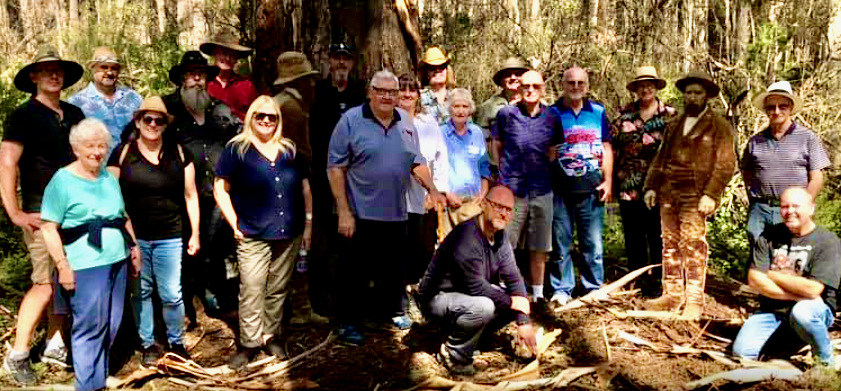
ABOVE : Ned Kelly Sympathisers lined up in front of the now officially debunked “Kennedy Tree”
In 2019, a group of four amateur historians calling themselves the Kennedy Tree Group announced in a media campaign that they believed they had found the actual tree beside which Ned Kelly murdered Sgt Michael Kennedy in 1878. They made their findings available in a couple of reports for download and invited the public to scrutinise and discuss them on their Facebook page. They asked for a formal investigation to be done, saying that they were working with the authorities to get this tree recognised by Heritage Victoria and protected for future generations. Leo Kennedy, great grandson of the murdered Sergeant called it a ‘sacred site’.
A few weeks ago, I wrote to DELWP to find out what, if any progress had been made in their investigation and this was their response:
Hi David,
I must once again apologise for the delay in getting back to you. I do however have an update. We have now considered the material provided by the Kennedy Tree Group and have decided not to take further action. From our perspective, there was not sufficient certainty about the identified tree being the location of Sergeant Kennedy’s body to alter Heritage Victoria’s existing registration of the Stringybark Creek Site (VHR H2205).
We have written to the group to inform them of this decision.
Regards,
Clare
Obviously for the KTG, after all the work they did in trying to find this tree and have it recognised as a place of historical significance, this will be disappointing news, which might be why they haven’t got around to making the news public. However, after doing my own research and evaluation of their reports, I am not in the least bit surprised by this news – it’s what I expected would happen. Their case looked very weak to me, and I tried to make this clear on their site and my own, but the KTG and none of their supporters were persuaded by any of my mumblings. So I, and everyone else just waited for the authorities to look at it. I’m hoping the KTG will now accept the decision of the independent umpire, thank everyone for their interest, pack up their site and move on.
I guessed that if they ever got around to making a public response to this official rejection of their claim, it will be to push back against it and insist that the DELWP experts also got it wrong. I say this because of the way the Kennedy Tree Group responded to every single argument against their claims that I put to them. They rejected every item of the substantial historical documentary record that undermined their claim, they rejected the views of almost every single other amateur historian who had different views to their own on every and any aspect of the subject, and in the end, they simply stopped answering questions on their page unless they were from supporters. About three months ago I asked them on their page about the claim Doug Morrissey made in his latest book that Burman wouldn’t have known where Kennedy was killed and so selected a random tree for his re-enactment. There was no response. A year before, they commented that several questions of mine that were unanswered WOULD be answered but at that time they were busy. They’ve still not answered any of them.
Particularly troubling to me at the time, and illustrative of the aggressive manner in which they and their supporters defended these claims was their response to an investigation that was done at their site by Bill Denheld. He posted a video of metal detecting near the tree, a process that involved raking aside superficial leaves and debris which were later replaced, and digging a bit deeper in the two or three spots where something was detected. In fact, nothing of significance was found. KTG members and supporters rounded on Bill like a pack of baying hounds, calling him a criminal and a vandal and posting all kinds of absurd hyperbolic and abusive claims such as that he had destroyed the place, desecrated sacred ground, behaved like a dog looking for a bone and offended all the police descendants. They ran off to complain ‘en masse’ to Heritage Victoria and to DELWP and to the mainstream media and made statements that resulted in a newspaper article targeting but not naming Bill entitled “No respect for History”, a headline that flies in the face of the fact that it was Bills nomination of the entire area that resulted in it being named a heritage protected area (VHR H2205).In getting that protection in place its unarguable that NOBODY has shown greater respect for the history of the place, and done as much as Bill has to protect it. In spite of that , the KTG posted this disrespectful article to their page and encouraged the pile-on. Aidan Phelan posted a long rant on his Bushranger page that attacked Bill and me as well, a post that was so offensive that Facebook removed it, but undeterred Brad Web of Iron Outlaw shamefully reposted it on his site, where it remains. Eventually DELWP announced Bill hadn’t done anything wrong but there was no apology from his abusers and accusers.
The greatest irony of KTG members and supporter’s horrible over-reaction was that it backfired disastrously on them. Their confected outrage spurred DELWP to take their claims seriously and investigate them, but instead of backing the KTG claims as they expected, as we have now seen DELWP ultimately dismissed them altogether. Now, in the light of DELWPs decision, I can’t help wondering how all these people are feeling about the ill-mannered way they behaved in defence of a claim that has now been rejected.
The KTG also claimed to have located the site of the police camp where the police were bailed up and Lonigan and Scanlan murdered. Its location was determined by working backwards from the so-called Kennedy tree, but now that the Kennedy tree site has been rejected, presumably the police Camp site claim will have to go with it. The methodology that they employed to identify the Kennedy tree has now been proved unreliable by DELWP so it would make no sense to rely on it in making the case for the police campsite.
Wouldn’t it be great if the KTG humbly accepted DEWLPs decision, agreed that their well-intentioned amateur effort turned out not to have found a historical site, apologised to their supporters for leading them up the garden path – or is it the bush path? – thanked everyone for their interest and then went back to the drawing board? Maybe they will think again about why they are the only ones who said the tree where Kennedy was murdered was on the same side of the creek as the campsite, maybe they will think again about why they are the only ones who said the two sites were a minuscule 200 yards apart, maybe they will think again about why they are the only ones who said that the tree was due north of the Campsite? Maybe they will withdraw their unsupported claim that local farmers perpetrated a mean hoax for generations, falsely labelling a tree as the Kelly tree so visitors wouldn’t walk on their land? Maybe they will stop trying to convince everyone that a double tree can be seen in the Burman police camp photo, that a tree with an invisible trunk in 1878 is the tree they called the Starburst tree, that the slope everyone else can see in the background is an illusion, that saplings leaning over and lying on the slope are fences?
Maybe….but I dont think they will.
KTG supporters are almost entirely Ned Kelly Sympathisers – seen standing with KTG members in front of the ‘Kennedy tree’ in the photo at the top of the page – and more or less to a person, like Kelly followers in general they are people who reject the historical record, reason and logic whenever it disagrees with anything they believe to be true about the Kelly outbreak.How many of them have announced their opinion of Steele has changed in light of the recent discussions about an Enquiry that nobody drew to their attention to till now? How many have changed their opinion of Fitzpatrick in light of all the careful re-analysis of the historical record and the publicity about the petition from Lancefield residents? How many of them have announced they no longer support the idea of a republic of NE Victoria in light of Dawsons devastating demolition of the arguments supposed to have supported that notion? Almost none is the answer.
I have a feeling they will all do the same here : cling to their positions as if they were holy writ. The KTG defence of this tree up till now has involved an almost complete dismissal of the historical record, a dismissal of common sense views of what is seen and not seen in the Burman photographs and a dismissal of everyone else’s opinion but their own about how it all fits together. I predict they will also dismiss the Umpires decision about their tree and just add this claim to the long list of other claims they believe to be true about the Kelly Outbreak that are equally irrational and unsupported by evidence. Watch this space – I would love them to prove me wrong but I am not holding my breath.
Hi David, my general view of the Kelly nuts as I affectionately call them is that they consist mostly of people who think Ned Kelly was a top bloke, a viewpoint that is only possible via a Kenneally/ Brown/ Jones view of Kelly that has been extensively exposed since 2012 as built on ignoring or rejecting vast amounts of the historical record that contradict it.
They have for the most part fairly primitive research skills and don’t go much beyond the Royal Commission minutes (which was largely an enquiry into police deficiencies as to why it took so long to catch four lads in the bush) and Ian Jones’s text and sometimes reference notes, which are highly selective and often contain errors of interpretation or fact. Add to that selective newspaper reports of the day and you have something like a year 11 or 12 research project with as little weight or importance.
The couple of exceptions are McMenomy, McQuilton and Moloney, all of whom wrote decades ago and none of whom had anything to say when Ian MacFarlane’s volcanic and meticulously documented “Kelly Gang Unmasked” blew much of the Jones narrative out of the water in 2012 and paved the way for a wholesale ongoing re-evaluation of earlier writings on the Kelly gang, most of which since the mid 1970s was written under Jones’s influence, and often with his direct input.
As such they are by and large stuck in Jones’s narrative and don’t have enough independent critical and analytic research skills to see their way out. They can’t engage in academic style discussion so they get personal, but only succeed in making themselves look more stupid to anyone outside the nuthouse.
There appear to be only two contenders with solid arguments for the SBC site; these are the CSI group and Bill Denheld who defected from that group for the reasons documented on his Iron Icon website. Of these, Bill is the only one who has put up a solid case against all other contenders. Anyone who disagrees with Bill’s case has to come up with a better one, and so far that hasn’t happened.
You’re right, most Kelly nuts are unable to do the critical analysis of what they think is history, and jettison the bits that are wrong. Instead, like religious converts they defend what they accepted as true in whatever book they first read about Ned Kelly , and describe everything that challenges it as ‘anti-Kelly’ in exactly the same way as Mormon missionaries describe anything that challenges their crazy religion as “anti-mormon”.
Its also interesting, to continue the analogy to religious belief, that so many of the prominent Kelly apologists and spokespeople describe their Kelly beliefs as having begun at a young age, such that the ned story becomes deeply embedded in their psyche and their memories of childhood and growing up, much as religious beliefs often are, and like religious belief they become hard to shake off later in life. Catholics for example struggle to deny they are Catholics later in life, so instead often just call themselves ‘lapsed’ once they’ve accepted they dont accept much of the basic teachings of their church.
The Kelly people collect Kelly memorabilia like the religious collect icons that decorate their homes, they set aside cabinets and man-caves and wall and shelf space for all this kelly iconography that reminds them every day as they walk through the house, hop in the car with Ned plates and Ned key rings and ned junk dangling off the rear vision mirror, that ned is their hero and guiding light. I am amazed at how often I read on Facebook, Kelly nuts showing off kelly books they own but havent read! Just having the book is all thats important to them. Challenges to those beliefs feel like a personal attack to these people, whereas for people like me, who wasn’t raised a Neddite, looking at the claims objectively and accepting or rejecting them on the basis of a rational argument, evidence and logic is quite easy.
But when you think about what a violent and unpleasant character Kelly actually was, a bully, a liar, a triple murderer and failed mass murderer with a gloss and a superficial charm that fooled so many, their reverence for the man seems quite revolting. The denial mechanisms operating inside the heads of these people must be in overdrive, day and night.
Just reading a post, on the Kennedy tree, and the photo that was at the start of the article. Both myself and my son are in that photo, and I would like to point out that we are descendants of the Police who were involved in the hunt for the Kelly’s. We are not sympathetic to either side, but are interested in the history involved.
Stuart says that two groups have come up with solid arguments for the stringybark creek murders the csi team and Bill Denheld then in a few words says that only Bill has put up a solid case. An examination of the extensive report of the csi shows how this claim by Stuart is bunkum they have given much wider prominence to the available evidence than Bill who has never debunked the wide amount of evidence in the csi report (I say because he cant).
Stuart your bias is clearly evident and as you say you are an academic whiz then why not set about to dismantle each and all of the evidence that the csi team has provided which in my opinion when taken as a total forensic view makes Bills scant evidence pale into insignificance.
MY money is on the csi by a mile to give the best most extensive analysis of the probable place at stringybark creek.
Hi NEFC, I had a chuckle at your exercise in mind reading about me, where you claim I call myself an academic whiz! Never have, never will. And your pointless challenge that I should “set about to dismantle each and all of the evidence that the csi team has provide”. Why would I even consider bothering to do that when Bill has already tackled it with years of on the ground observations?
You seem to agree that these are the two main contenders over the SBC location, which was my key point. If you have read David’s blog here for a while you will know that I have never claimed to supportup either position but have formed the opinion – which may be wrong – that Bill put up a better case.
If you have nothing better to do, you could spend some time critiquing Bill’s position and rehashing the CSI case for why Bill is wrong in your opinion. Or just stick to your view based on what CSI have published, that they have the better case, and accept that Bill has at least put up a solid case even if you reject it. Both cases seem far better put together than any of the other contenders, but then again, who knows?
At the end of the day it doesn’t matter where exactly the SBC murders took place. What matters is what happened and that can be known with a high degree of certainty. And Jones got it almost entirely wrong, as has been discussed in bit and pieces over time by several people on this very blog. I’ve attached a pic of my Kelly mug for your entertainment. (And as we all know, he never said ‘Such is life’.)
Attachment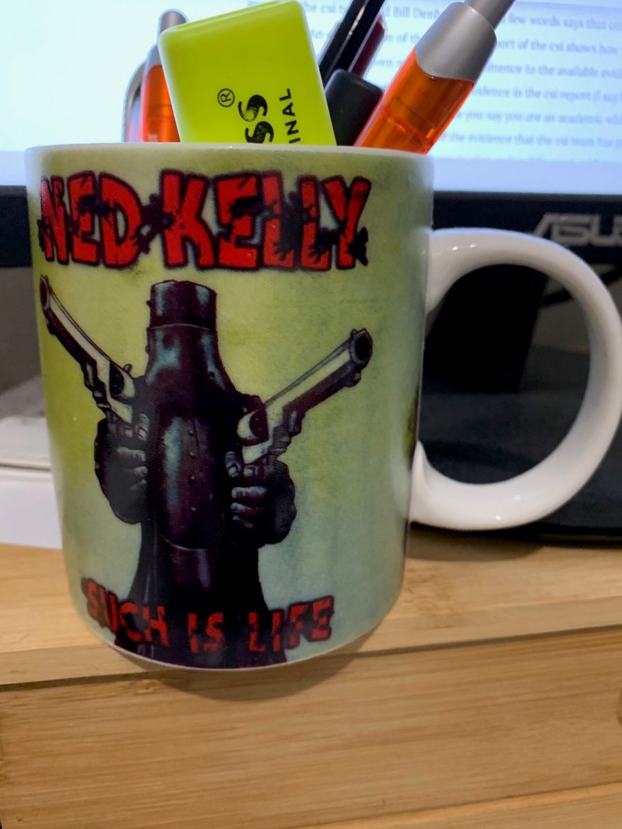
Hi NEFC, thanks for your posts. Can I take it youre not convince by the KTG claims? What may I ask do you think are the flaws in their case? I think one place they really went wrong was in prematurely going to the press and making all those grand announcements and promoting themselves as clever local identities who discovered something significant. Its left them with no room to back down, except into humiliation and embarrassment for shooting their mouths off before the experts had a chance to look at it – for that matter even before they had let other interested amateurs like ourselves to critique it. I think if they had done it in reverse order they might have had second thoughts about going public once independent scrutiny had exposed their flimsy argument. Now I think they feel unable to let it go to back down and admit they got it wrong because to do so would be to lose face. Who wants to do that?
As you know I’ve made a detailed analysis of the CSI claims and found them wanting. I accept the CSI team made a genuine and determined effort to find the site but it has some serious and in my view fatal weaknesses, not the least of which is their misorientation of the Burman photos. At least the KTG got that bit right.
The other really very weak link in the CSI argument is the need to accept that the burl on one of the trees in the Burman photo ( KTG called that tree PC1) is the same burl seen on a tree in the Beautiful Mansfield photo, even though the two burls are entirely different shapes. These are very amateur non-scientific arguments which are vital for their case but I regard them as fatally weakening it.
I still back Bill wholeheartedly but even he says if you can show he is wrong so be it!
David, I note with interest that you wrote the following in your above header remarks:
“Maybe they (KTG) will withdraw their unsupported claim that local farmers perpetrated a mean hoax for generations, falsely labelling a tree as the Kelly tree so visitors wouldn’t walk on their land?”
Maybe you should ask the same of Bill as he also claims that the tree was falsely labelled so people would not have to clamber over private land.
Glenn
Thanks Glenn. I was not aware of that so I’ll check with Bill and see what he has to say.
It would be helpful and interesting to hear what it is about the KTG proposal that you see as its flaws.
David, for your reference:
Adam Ford got it wrong : the Police Campsite is not at the picnic ground (Part Two)
Bills Comments. November 26, 2019 at 10:27 am
Where we read that Beasley grew tired of taking people to actual spot so (falsely) marked a dead tree not far from his house.
Glenn
Glenn is referring to my Blog post “Adam Ford got it wrong” and is pointing out that the KTG weren’t the first to claim a random tree had been selected and labelled as being at the site of the police camp, just so that visitors wouldn’t walk on private land. He points out that Bill mentioned it also, and if you go back to that Blog Post you can read this interesting comment by Bill, which is itself taken from the Age Oct 10 1995:
“Mr Jones says that in 1960 he learnt there was once a local man who grew tired of people asking where the battle took place, so he randomly cut a legend into the Kelly tree to put an end to it. Everyone simply accepted that here was the true site. In time the site became formalized for parking. The tree now carries Ned’s metallic likeness. The same man who told Mr Jones about the tree said the real site was further south along the creek and described it. From that day, Mr Jones set out to find it.”
Interesting to note that this informant told Jones that the real site was further SOUTH – which as well know is further away from the Picnic ground, the CSI site and the KTG Site and in the direction of Bill site!
David, what I’m pointing out is that it is unfair to only ask the KTG to withdraw their unsupported claim that local farmers perpetrated a mean hoax for generations by falsely labelling a tree.
When they are not the only ones to claim that a random tree was selected as the area nearby the Kelly tree does not fit in with their own conclusions.
From what I have read Ian Jones has been heavily criticised on this blog for being selective with his research and wrong about many things. His true site location being one of them.
Glenn
I understand where youre coming from Glenn but it was a discussion about the KTG not about Bills site. Next you’ll be criticising me for not mentioning the CSi view or the Ford view of every other point I make about the KTG. There is a difference though – Bill was citing actual oral history, not speculating as the KTG seemed to be doing, purely in order to make their theory seem plausible. Also, their speculation was that the site was moved further south whereas Healy/Jones and Bill were saying it was moved north.
Maybe I should be asking why the KTG say the hoax site was created south of the true site whereas everyone else says it was made north of it?
It’s a pity this Kennedy tree thing is causing more divisions between those interested in the history at Stringybark Creek. I met Adrian Younger and Tony King once and they are good people with a passion for the area. They put a lot of work into their report and did not have to run it past anyone before submitting it to DELWP for review (although it is a pity perhaps that they didn’t). DELWP would have given their report serious consideration because if they are correct about this tree then the boundaries of the heritage overlay would need to be expanded.
The purpose of this post though is not to express a view one way or the other about the KTG report. Rather it is to suggest that everyone with an interest in SBC should put aside their differences and look instead at what they can agree on. Obviously one thing everyone can agree on is that SBC (and Bullock / Kelly Creek) is a historically significant area even if we cannot agree about specific sites within the area.
Three years ago I wrote to Mansfield Shire Council in response to the publication of the Ned Kelly Alive Concept and Business Case report. The report recommended various priority projects to leverage the Kelly story as part of the North East Region’s tourism offer. For Mansfield, the priority project was to develop the rather clumsily titled Mansfield Police Memorial and Tour Operator Hub (Priority Project 4), with the development of a Kelly Trail at Stringybark Creek (SBC) as a focus of this project.
The Ned Kelly Alive report seemed to have been prepared without knowledge of the new signage the land manager at SBC (DELWP) was at that time about to implement. The signage is generalised and does not identify specific locations and I believe the reason for this is due to the disagreements between different people with an interest in the area. With at least four parties having identified different sites for the police camp (Denheld, CSI, Jones and now Adam Ford) and now with multiple Kennedy tree sites having been speculated upon, DELWP really had no choice but to run with a generalised signage theme.
Anyway, the reason I wrote to Mansfield Shire Council was to suggest that the whole SBC – Bullock Creek area be developed and managed as a larger “Stringybark Creek Historic Site”. The Kelly history is of course the most interesting aspect of SBC and Bullock Creek, but past gold mining and timber getting activities also provide further interest. The old bridle trails that passed through SBC and which connected the settlements to the south (Mansfield) with those to the north are also interesting – evidence of those trails still exists under the overgrowth and weeds.
Presently the whole area is very poorly managed, which is an indictment on DELWP. The very interesting Bullock Creek area is in a spectacular amphitheatre-like setting which can hardly be appreciated due to the overgrowth and blackberries which makes passage through this area almost impossible. If this area was incorporated into an enlarged historic area under separate management I think this would be a very good outcome.
I never did receive a reply back from the Council to my letter, but perhaps a Stringybark Creek Historic Park is an idea that everybody with an interest in this area could get behind. The location of the police camp site and the Kennedy tree site need not be identified – perhaps the different viewpoints regarding the true location of these sites could be part of the reason for visiting the area, i.e. let visitors consider the different evidence and make up their own minds.
Thanks Peter, the idea of interested groups setting aside differences about details and joining forces to promote a bigger concept for the entire area is a great one, though as you know in the Kelly world people tend to stake out territory and defend it against all comers. Mind you, it doesnt have to be one or the other – both projects are valid in their own right I would say. What I wish is that HV would do with the other proposals what they did with the KTG one, and subject them all to critical analysis using their experts and tell everyone what they think of all of them. I think one of the things that frustrates Bill is that nobody will take his proposal seriously and do the analysis. He has always said he is happy to be proven wrong but has assembled a formidable set of arguments and evidences for his site, and I think he is on the money. It would be marvellous for it to be recognised if thats what the expert analysis decided, not just for Bill but for all of us who would like to know.
Ive never been to the Kelly camp area at Bullock creek but it sounds amazing.
Hello David and Glenn, re your comment 4 May at 5:39 pm
The K.T.Group are wrong if they claim the third Kelly tree was a hoax. The last Kelly tree was marked following a succession of events spanning 50 years starting with new settlers to the area. Maybe each new comer was just curious while others knew exactly where things had happened – but they were given little credence.
As it turned out the police camp fell just outside the southern boundary fence line of McCrum’s then Beasley’s land of some ½ Sqr Mile. Although, the first Kelly tree where Scanlan was shot could have been on their land if the road is any guide to where the western fence boundary would end up.
I could go on but this topic is about the rejection of the KTG reports by Heritage Victoria and DELWP historians.
I understand the report HV were most impressed with was by Mr Kevin Tolhurst submitted back in April last year, and it’s a disgrace that you had to dig deep for it to become available.
Is there a possibility the Tolhurst document is available online?
This will allow all readers here understand his reasoning, while otherwise the K.T.Group can just stay silent.
Bill
By all accounts lets make sure History is recorded correctly
Attachment
I would think that Heritage Vic & DELWP would have done their own independent research apart from studying the various other true site submissions offered for consideration, and are now satisfied that the site of the police camp was in the area nearby today’s Kelly tree. The exact spot may never be known, only that it is nearby.
Perhaps they have learnt from the past mistakes in following the convictions of a high profile Kelly historian and moved the site further up and on the opposite side of Stringybark Creek.
If proper research had been undertaken at that time the site would not have been moved in the first place.
As for the Kennedy tree….. I’m fairly certain that mention is made on the signage at the current location that it was engraved with a K and later cut down for timber. I have also been told the same by knowledgeable researcher.
I have spent days scouring through the bush and although there are a couple of old tree contenders that may look nice, the chances are that the actual tree has long since gone.
Glenn
Glenn youre saying if proper research had been done the site wouldn’t have been moved to Jones site. Where was the original site – near one of the Kelly trees?
As to what HV has done recently I think all they did was investigate the KTG claims. Leo Kennedy says in his book that his father told him the tree had been cut down, but obviously changed his mind after becoming involved with the KTG. The fundamental problem with the KTG people is that they are so convinced by what they see with their own eyes as similarities between their tree and the one in the 1878 photo that no documentary or other evidence can persuade them otherwise. Visual impressions can be so powerful and hard to shake off.
I like Peter’s suggestion to turn the whole of SBC and Bullock Ck area into a historic park to be cleaned up by volunteer history groups aided by DELWP so that key locations can be viewed as they might have been 140 years ago.
While I respected Glenn’s attention to detail, he and Kelvyn Gill mainly followed Linton Briggs’s conviction even though overnight he did a 180 degree reverse in direction of the Burman photo when it was pointed out no Burman photo could be taken there. That also contradicted Ian Jones’s and local Jack Healy’s 1920s knowledge of site shown to Jones, but Jones did not believe him until 30 years later, and in his book Jones establishes his East bank site in preference to Healy’s west bank site.
In his Seminar Papers Jones said “ if anyone can find the remains of a hut – that would Identify the true site of the police camp”
How Linton Briggs came to believe in his west bank – west of road site we do not know but was very flawed in my opinion.
See Woman’s Weekly interview with Jack Healy 1964 only a year after he showed Jones the site
https://ironicon.com.au/images/jack-healy-on-sbc.jpg
Picture -Jack Healy with pipe circa 1930s
Attachment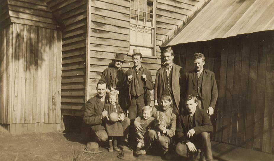
In the photo above the man bot left is Harry Engelke who lived top end of SBC road and also ran the sawmill that was built over the Kelly camp hut site. I communicated with his son Charlie back in 2005/6 and he gave me all the relative SBC and Kellys Ck photos to scan of which this one is No 55.
One other important photo in the set was the Mr Cuddon photo where he stands in front of the 2nd Kelly tree. It was in this photo at the back left I identified the current Kelly tree which was forked, and the reason it was not cut down and still standing in the 1930s.
I would say that any tree that was not forked but left standing might have been for a reason.
It could be the tree that Leo and I identified on east bank in 2014 with a circumference of 5 metres may well be the original K tree as it has a straight trunk on easy accessible land.
Attachment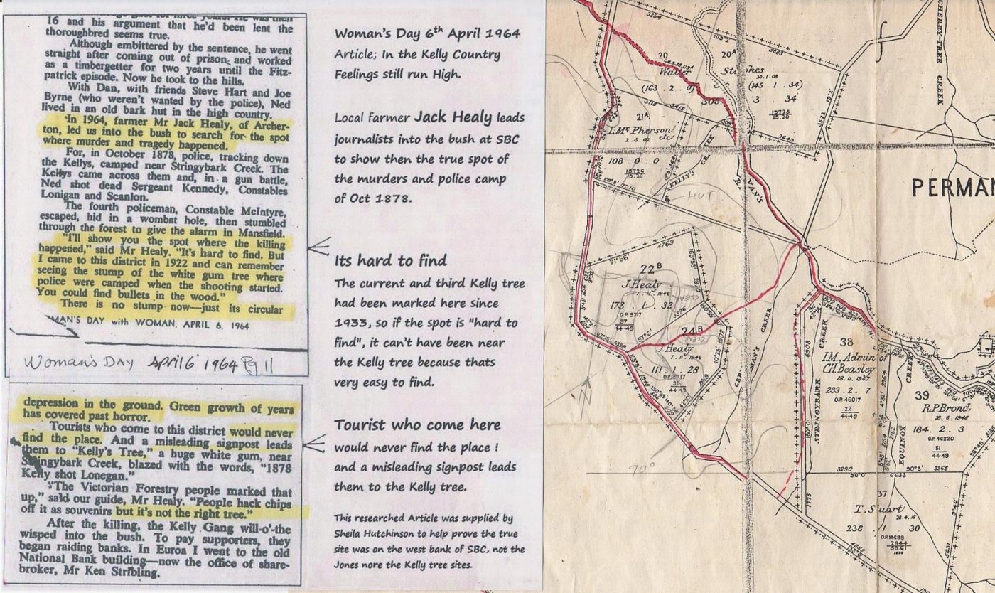
Below is a typed copy of a hand written letter from Charlie Engelke to Bill Denheld in 2003. Posted on the now defunct: Ned Kelly Truth Forum.
“ I understand (was told by Dad) that the stump was pulled out by Mc Cashneys. He was working in the mill at the time. I understood it was in the way of a proposed tram line.
There were no remains of a tram line there so it seems the plan was changed. Dad also used to say that Mc Cashneys had no sympathy for the Kellys or Kelly history.
The stump was on the west side of the creek. Mc Cashneys mill went into the district in 1916 according to records. As I understand, Mc Cashneys cut into virgin forest and there had been no mill activity there previously.
We were always told that Charlie Beasley put the sign on the nearest tree to the stump which was pulled out. This was said to be the site where Kelly’s shot the police. If evidence exists that the shootings were on the other side, well so be it.
We were always told it was on the west side adjacent to the tree marked by Beasley. Dads photo of Mr Cuddow (or Cuddun) the Pivot sales manager, standing by the tree was taken in 1938.
The sign would have been put up well before 1938 but I couldn’t say when. Somewhere in the early mid 1930’s.
As to when Tim Brond marked the other tree, I don’t know when this was done. I’d have to take Sheila’s word for that. Locals always considered it to be the wrong place.
The top broke off the tree signposted by Charlie Beasley and left 10 or 12ft standing which rotted and fell down very much later in the 1940s.
I couldn’t say the precise year though but it stood for quite a long time. The photo of Beasleys tree is looking east with the creek in the background.
The photo of Dad standing by the stump is taken looking west.
This is indicated by the slope of the land and the fence and bush in the background. (Looking across the road) ”
Sheila ( Forum post – 23/09/2010)
“Charlie Engelke the owner of the Cuddon photograph and the one of the stump of the original Kelly tree is adamant that the photographs were both taken on the west side of the creek, not far south of the present Kelly tree.”
Both Jack Healy and Charlie Engelke correctly said the current “Kelly Tree” was not the right tree, actual place of the shootings. As the actual place was close to the tree signposted by Beasley.
Placing the site on or near the white hill. (Just up from the car park)
Glenn
Bill, that is an interesting survey map you have attached to the article from the Woman’s weekly.
What is the date of that map? The settlement history of this area is also a theme that could be explored as part of a Stringybark Creek Historic Park. However my idea of an historic park could only happen if everyone with an interest in this area could put aside their differences and work together to make it happen. I think such a park could be a significant attraction. I might put some ideas together – perhaps David would consider making it a separate blog?
Hi Peter,
I must admit to thinking your great idea could never work because there are so many animosities and old disputes that were never resolved, that the parties could never come together. But today I thought well it definitely wont happen if nobody tries to make it happen and because it does seem to be such a good idea I thought well why not at least try?
So if you want to make something for the Blog I would be very happy to post it, and promote it on the Facebook pages as well.
I wonder what Glenn thinks….
Nice thought. But in reality you would have to have a medical emergency clinic on site.
As it would probably end with fisticuffs. Glenn
Peter’s proposal of a managed SBC Historical Site within which “The location of the police camp site and the Kennedy tree site need not be identified” but the broader area including mining history was recognised and promoted makes excellent sense. SBC was many things before the SBC murders, notably mining and bridle trails, stock theft routes and Bullock Creek he notes that all give context to the area. It is not just about the Kelly gang killings.
Thanks Glenn for the Charlie Engelke letter. This gives the history of the trees and – in it he says that Dads photo of Mr Cuddow standing by the tree taken in 1938. He is referring to the second Kelly tree.
Charlie Engelke also explains that the sign seen in the cuddon photo was put on the nearest tree to the stump by Charlie Beasley, which was pulled out and that this was the site where Kelly’s shot the police.
Bill in his recent post now tells us that he has identified the current Kelly tree which was forked in the back left of this photo.
If so then it would seem that BIll is now acknowledging that the local people who knew where the camp was has now accepted that the camp site was close to the current Kelly tree.
The CSI paper has included photos of the first (a stump), second (cuddon ) and third (current) trees and identifies the current tree in the background of the Cuddon photograph and says that the angle of sunlight reflecting on the tree marked by the fingerboard indicates the camera was facing to the north east from a position on the western bank within the immediate vicinity of the camp site.
So here we can read the descriptions provided by the residents of the area who unequivically describe the location of the police camp and the words of Bill who now acknowledges that he can identify the Kelly tree in the photo.
So it seems Bill is in agreement with the CSI that the camp site is in the area of todays tree.
Oh well here we go again CSI! I shouldn’t put words in Bills mouth but I would say yes he does agree that the camp site is in the “area” of todays Tree. As did Ian Jones. As did Adam Ford. Only the KTG say its NOT in the “area” of the current tree. Precisely WHERE in that general area is still up for discussion.
But I’ll say again what Ive stated before : before you start arguing about the minutiae of the CSI claim you have to first accept that the two completely different looking ‘Burls’ are the same thing, and you have to accept their assertion that in taking his photos, Burman put everyone in completely the wrong place. For the life of me I cant see a good reason to accept either of those two necessary preliminary steps in the CSI argument, and for me it renders the rest of the CSI claim moot.
At least we all agree the KTG claim is unsustainable.
David, based on the photographs and the written evidence provided by locals that lived in the area the location of the original Kelly tree can be closely established. And removes any notions that a tree was just randomly selected out of convenience.
From here it doesn’t really matter what anyone thinks or says……the locals have provided enough information for us all to agree on that with a high degree of certainty.
On that basis I agree with you that the KTG campsite claim is unsustainable.
Glenn
I also wish to thank Glenn for the Engelke information which he put up on May 8.
This letter should be considered as the most important document which surpasses the Burman photos as it very clearly tells explains where the police camp was by the way that the first and second trees which locals of the area used to mark the place of where the police camp was. Then by looking at the photograph of Mr Cuddon in front of the second tree and seeing in the left background a forked tree which is claimed to be the now existing tree (number 3) and which BOTH BILL AND THE CSI PEOPLE seem now to agree upon that the camp for the police was in the “area” near to todays tree.
There is absolutely no way that this tree could be seen from Bills two huts site which from my recollection would be 300 or more metres from this tree.
It seems Bill has unwittingly put the matter to rest with his acceptance that the Cuddon photo also shows todays tree in it as his claim for the hut site cannot be said to be in the “area”
The DELWP now have the text of the Engleke letter (if they didnt already have it) and the Cuddon photograph (which is in the CSI report) and unless these two things are ignored (as it would seem from Davids recent post) there is no need for Peter Newmans idea of people working together to sort this all out as it is all clearly detailed by the CSI people in their CSI@SBC paper.
I takes me hat off to the CSI people (now without Mr Linton Briggs who passed some months back).
Please let’s not get carried away.
The use by Glenn and NEFC of a letter sent to me by the son of Harry Engelke ‘Charlie’ who was just a child at the time when his father worked at the Toombullup and Kellys Crk sawmill during the 1930s.
A scan of the 2003 letter was uploaded to the ‘Ned Kelly Truth Forum’ where much was debated in detail. –
https://ironicon.com.au/sbc-dee-bate/page10.htm This forum consist of 22 pages and more than 500 comments.
In the letter, Charlie Engelke tells me- ‘as far as he knows – ‘the 1878 Police camp site was near the second Beasley- marked Kelly tree’ because it was based on a photograph of his father standing near a rotten tree stump that was being removed to make way for a ‘sawmill tramway’ supposedly on Charlie Beasleys land. It would seem strange to place a tramway on private land? but Kellys Creek was riddled with tramway right near where the Kelly camp had been.
In the photo, notice how far the fence is in the background. This is not Stringy Bark Creek.
More to follow
Photo of Harry Engelke- Kelly stump photo
Attachment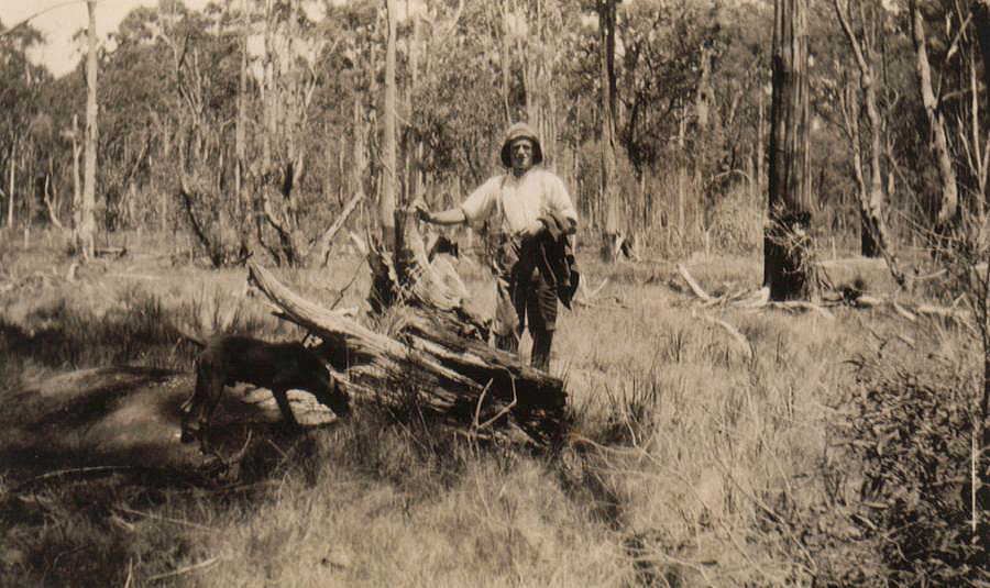
Re: Please let’s not get carried away.
Bill. It is no easy task to make much sense at all with what you have written. If this was presented by the KTG or the CSI team I am sure that it would be critically ripped apart by yourself and David.
First: You assert that photograph of Charlie’s father Harry shown with the stump of the Kelly Tree, was not taken near SBC and it was most likely photographed at the Kelly’s Creek sawmill site. As it was most likely one of the target trees near Kelly’s camp.
That it was likely situated on the edge of an eroding embankment when the tree fell over in a storm pulling its root system out. Then go on to say that perhaps this stump was photographed in JJK’s book on page 56 or belonged to the tree page 58?
*If the tree fell over and pulled the root system out then someone must have planted the stump back into the ground by the time JJK photographed it. Or perhaps the main part of the tree broke off leaving the stump in the ground which later fell over leaving all of the heavy roots exposed by the time of the Engelke photo of the stump. The rest of the tree having being cut up or removed from the site.
JJK and his guide must have been completely mistaken as beneath the photo he writes: “Background shows the position of Sergeant Kennedy when shot by Ned Kelly from behind the stump in the foreground.”
(For your reference you will find the post made by Sheila on the kellycountry2000 members only forum of which you have a copy.)
Second: You state that “Charlie’s understanding of his fathers ‘Kelly-stump’ photo, it was taken at or near the police camp location was contradicted by Jack Healy in 1964.”
I assume you are referring to what Jack Healy was quoted as saying in the Womans Day article 16th 1964. Which reads:
In 1964, farmer Mr Jack Healy, of Archerton, led us into the bush to search for the spot where murder and tragedy happened. ……………..
”I’ll show you the spot, where the killing happened,” said Mr Healy. “It’s hard to find. But I came into this district in 1922 and can remember seeing the stump of the white gum where the shooting started. You could find bullets in the wood” “The Victorian Forrestry people marked that up,” said our guide, Mr Healy. “People would hack chips off it as souvenirs but it’s not the right tree.”
Reporter: There is no stump there now – just a circular depression in the ground. Green growth of years has covered past horrors. Tourist who come to the district would never find the place. And a misleading signpost leads them to the “Kelly’s Tree” a huge white gum, near Stringybark Creek, blazed with the words, “1878 Kelly shot Lonegan.”
Where does Jack Healy in 1964 contradict Charlie Engelke? He simply says that todays “Kelly Tree” is not the correct place as does Charlie Engelke.
You state that again: “In 1963 Jack wrote that the current Kelly tree location was completely wrong…..”
I assume you are referring to Ian Jones’s narratives that leads us to believe that Jack Healy actually showed him a site in 1960 which has since been proven incorrect.
Jack would have had to have said that the stump of the Kelly Tree “where the shooting started” was no where near the tree signposted by Beasley and on the opposite side of the creek. Such an important feature would not have been overlooked by Ian.
You have provided no evidence at all that Jack Healy wrote in 1963 that the current Kelly tree location was completely wrong. Unless you can I will call it what it is….fabricated nonsense.
Glenn
Continuation; Please let’s not get carried away.
At the time (2003), after careful study of the photos regarding Charlie’s claim (to me) that this stump area was the site where the three police were shot CANNOT be RELIED upon because Charlie is only repeating what he was told as a child. When I spoke Charlie by phone, I explained to him that the Burman photo taken of the Police Camp* could not have been taken where his father stands by a ‘Kelly tree stump’, he said – “well that’s what I was told “
* To my knowledge this image had not been readily made available in books until 1966. Only a limited number of postcards and the Police had these Burman photos.
The point is, when Charlie’s mother and father ‘Harry’ and other settlers moving into the area early 1920s and 30s, they would only have learned of the SBC- Kelly locations some ‘50 years after the event’. My discussions with Charlie was 125 years after the event, so we cannot take anything he said with certainty regarding the ‘ Police Camp location’. Very few people knew exactly where, not even the surveyor of the first map, he could only guess, and a year later he changed the location according to further assumptions.
Charlie’s understanding of his fathers ‘Kelly-stump’ photo, it was taken at or near the police camp location was contradicted by Jack Healy in 1964. In fact, I assert that Charlie’s father Harry as seen, was most likely photographed at the Kellys Creek sawmill site where they also had their house ( have photo), and at that time there were would have been several Kelly target tree remnants there when the sawmill was established at Kellys Creek around 1927.
Image 36-Engelke and kids photo. At left is probably Charlie and sister as toddlers
Attachment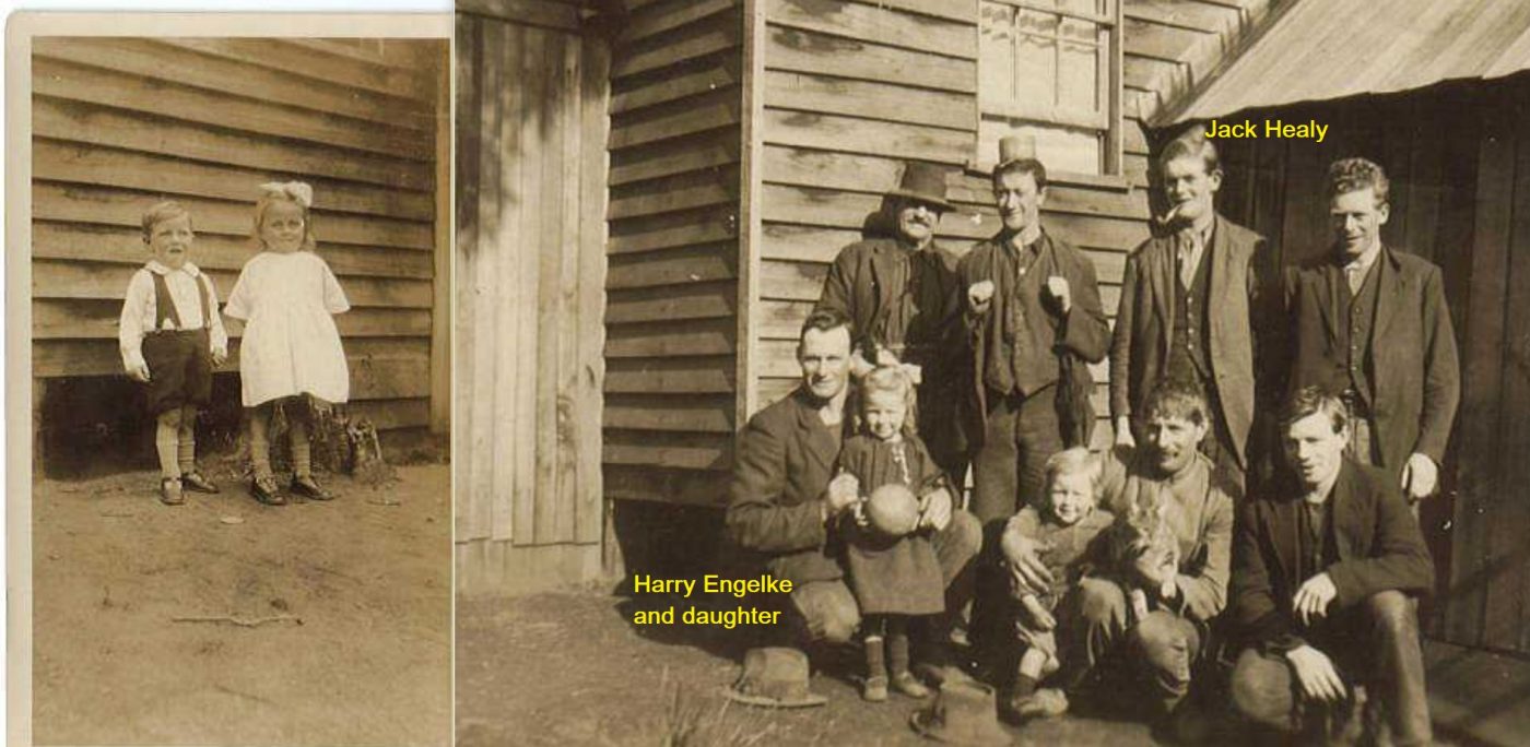
Continuation; Please let’s not get carried away.
In 1985 a well known identity, Mr Bill Stewart showed me the remains of a large Kelly Target tree that had rolled down into the creek below where the sawmill had stood in 1985. ( now in possession of Sheila and Joe Hutchinson.
However Charlie’s stump would not have been the same tree as it looked too too small.
During my metal detecting of SBC area in 2002-5 (and later), I found no tramways along SBC but were easily detected along the track into the Kellys Ck sawmill area. The objective was always to drag felled trees by Bullock teams to a loading ramp- and onto tram wagons to the sawmill to be cut up.
So with Glenn and NEFC pushing their CSI case to ‘conclude’ that the Harry- Kelly stump photo was taken at SBC, this is very unlikely as the Mr. Cuddon photo tree was close near the road, whereas that Harry stump photo appears to be about 20-30m or yards away from the fence line in background (if this was a road ?). However in their CSI@SBC report ‘Update July 2017’ they say the picture of Harry at the Kelly stump was ‘of the FIRST Kelly tree’ at SBC, this is contrary to the citation on the back of the photo. ( I would assert that they assumed they would get away with this as they also drag Sheila Hutchinson into the picture, and she may have made a statement on a forum, but she was also just a child when all this SBC became big news.)
Having a good understanding of SBC, the first Kelly tree area was pointed out to me by (deceased) Bill Stewart who we met in 1985 and we took him up to Kellys Ck to show him where I had found the bullet lead. He told me in his youth, he worked at the Kellys Ck sawmill (helping build it) On the way back from our trip to Kellys Ck, he got me to drive way past the Current Kelly tree up to the red hill (which seemed odd to me at the time), but he pulled me up as he pointed to an area in the bush where the first Kelly tree had stood, and 17 years later following Ian Jones instructions to his site, I would find the two huts where the Police had Camped on the west bank, and now realised why Bill Stewart got me to drive way up the road past the current Kelly tree to where the first Kelly tree had stood.
Now having more intimate knowledge of the area, I can see no reason to dig up an old stump up as suggested by Charlie, because the saw millers McCashney and Harper would not have wanted to spend any time digging it out the stump at all.
It was just left to rot, and perhaps this stump was photographed in JJK’s book on page 56 or belonged to the tree page 58?
What is more likely, this particular stump was part of a tree situated on the edge of an eroding embankment when the tree fell over in a storm pulling its root system out. So, if the photo inscription on the back (as recorded by me)- it simply reads “ Kelly stump Harry Engelke” not ‘the first Kelly tree stump’ as Glenn and Kelvyn want us to believe.
Photo – Harry Engelke and –Mr Cuddon
Attachment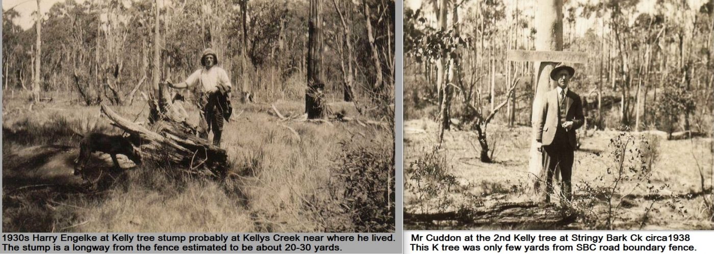
Continuation; Please let’s not get carried away.
In 1963 Jack wrote that the current Kelly tree location was completely wrong- meaning – Harry and son Charlie would also have known their considered police camp site was questionable, and oblivious to the fact that a photographer Burman had taken photos of the police camp. They would then have seen the current Kelly tree locality was flawed. I say this because it is not possible to take a ‘like Burman photo’ there in any direction. I also doubt any people settling in the area would have seen the ‘Burman photos’ in the early 1900s even though the photo existed as a postcard in Ned Kellys time.
Author J.J.Kennealy’s 1929 book ‘The Inner History of the Kelly Gang’ did not show the Burman photo, and nor did Max Brown’s, 1948 ‘Australian Son, nor Ian Jones’s 1993 Kelly book. If J.J.K or Brown had done so, there would not be this debating today. The location would have been settled with the arrival of James McCrum at SBC in 1884.
The first book to show the Burman photo ‘police camp site’ seems to be ‘A Pictorial history of Bushrangers by Tom Prior, Bill Wannan and H.Nunn 1966, then Keith McMenomy’s book 1984 and Ian Jones’s 2003 edition of Ned Kelly- A short life.
Attachment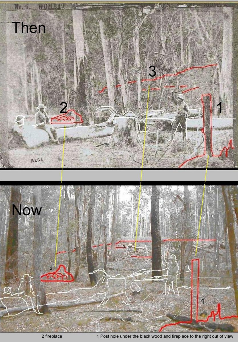
A view of SBC taken in the same direction as the Cuddon photo. The tree signposted by Beasley would have stood in what is now scrub further behind this image.
Attachment
Here we go again, but lets not get carried away.
In this above image posted by A nonymous re CSI@SBC person – does not show a reasonable likeness to the Burman photo, so because of that they only want to confuse.
In his picture, the current 3rd Kelly tree is hidden by the bush hard left.
The central tree is unrelated, but the tree in the very foreground hard right is roughly where the 2nd Kelly tree stood with Mr Cuddon. You will see there is no slope and the sun light comes from the wrong side.
It just so happens we discussed all this similar photo ten or more years ago and this is what I pointed out to the CSI fellows at the time.
Image http://www.ironicon.com.au/images/3b-SBC-news-and-views.jpg
Attachment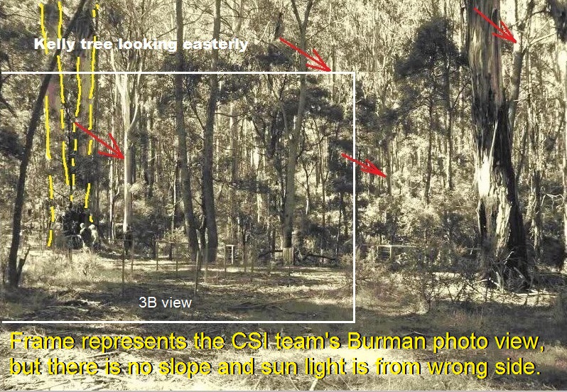
Bill, it was I that posted the image above. It’s a view of SBC taken in the same direction as the Cuddon photo. Showing the location as it looks today. That is all.
The sun light comes from the same direction as the Cuddon photo. But if you are referring opinions on the sun direction, slope height etc in the Burman photos…. Well, that has been debated in the past.
Along with debates about your site, the CSI site and the KTG teams “Tea Pot” tree, slope, camp location to the Kennedy tree etc etc.
Glenn
Attachment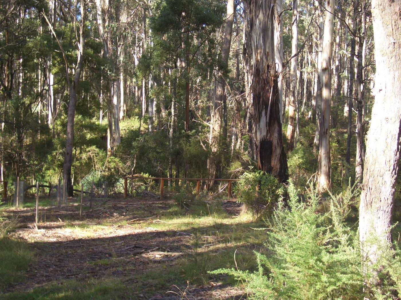
Of course the current Kelly tree is completely wrong but it is in the vicinity of the tree that mr Cuddon was at which is said to be the second tree used to mark the spot.
Would Mr Denheld who has claimed the present day kelly tree is seen in this photo be kind enough to address this photo and its contribution to the endless debate of where the police were camped??
Anonymous, please call me Bill, and tell me where I state the ‘present’ or current day Kelly tree is in the photo images that I provided ???? Readers will assume you refer to the images directly above, but no there is no Kelly tree in the images Then and Now
Please better explain?
Further to my earlier reply, I think Anonymous refers to my posting comment May 8 at 9;43
Ref to a ‘K tree’ in my later statement was meant to be understood as a potential Kennedy tree- not a Kelly tree.
Bill you asks Please better explain
There are two postings on the May 8 are the ones about the tree and mr cuddon and has the kelly tree in the background.
You say that One other important photo in the set was the Mr Cuddon photo where he stands in front of the 2nd Kelly tree. It was in this photo at the back left I identified the current Kelly tree
and Davids says that I shouldn’t put words in Bills mouth but I would say yes he does agree that the camp site is in the “area” of todays Tree.
So I again ask if you have identified the Kelly tree we know today in the cuddon photograph and it is said that this cuddon tree was the second tree near to the first tree and near to the where the police made their camp then why do you insist that your fireplaces are the right place because these are no where near the kelly tree.
The CSI claim is far closer to the Kelly tree than your claim
I think it best to save words and show a picture –
The picture is based on ‘Google Earth’ coordinates shown in pink background.
Item No 3 is where Constable Scanlan was shot and the first Kelly tree stood.
No 6 the second Kelly tree being some 200 plus m south (as per the Mr Cuddon photo tree he stands in front of).
No 7 the current Kelly tree is estimated 300 m south from where the police had camped.
Item No 2 shows the logs near where Const Lonigan was shot.
Anonymous then suggests “the CSI claim ( police camp) is far closer to the ‘current Kelly tree’ than my claim”
Then asks- “if I have identified the Cuddon tree?”
Answer, No tree, but back in 2003, I calculated the measurements as from a map supplied to me by Sheila Hutchinson, re ‘links’ measurements to establish this Mr Cuddon photo tree at around 804 metres from the junction of SBC and Ryans Crk, and this was supported by the CSI team who contracted a surveyor to do the measurement in 2009 to arrive at 803 m. BUT no, it was nowhere near where the police had camped.
See picture https://ironicon.com.au/images/05-SBC-Police-camp-site.jpg
Attachment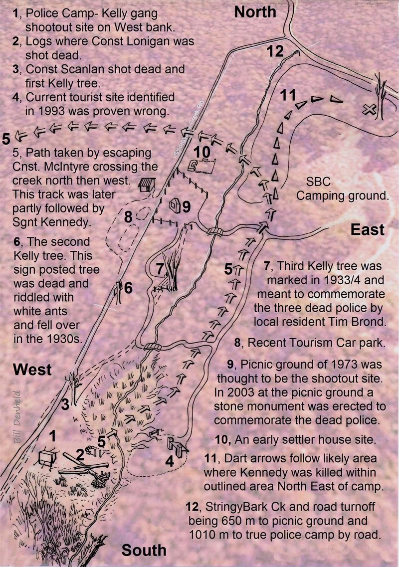
In the posting below by Anonymous, suggests a hut on the first and second survey map- 1884 and 1885 was near the Mr Cuddon photo.
Answer ; only Number 9 on my pink drawing above is the Mr Cuddon K tree photo where the surveyor had marked a hut at 804 m from Creek junction. BUT the second hut plot by the same surveyor in 1885 placed the same hut between figures 9 and 10 on the pink map above.
So to suggest the police camp was somewhere near Fig 6 and Fig 9.5 is a distance of 165 meters, and neither place is correct because no remains of a hut was ever metal detected at these sites and are erroneous, also there is no slope like in the Burman photos there.
I am confused.
These are the words in Bills posting
It was in this photo at the back left I identified the current Kelly tree
Clearly it states the current Kelly tree is to be seen in the Cuddon photograph .it would seem that this photo was taken in a direction of nor nor east if points 6 and 7 in the pink drawing are correctly shown.
I think that what the csi team did was confirm where the hut shown in both the 1884 and the 1885 maps in appendix 2 of their report would be which also seems to be in the proximity of where the cuddon kelly tree was.
The hut is shown near to the southern edge of allotment 25 which then was James McCrums and which later was to become Charlie Beazleys after the requisite survey was made – this survey notes are in the application papers of 22/44.49. The survey diagram shows an x with the words Kellys shot police here.
This is an important survey as it covers the ground from where Stringybark Creek road commences from in the north, and from the verge of stringybark creek road easterly to the Equinox creek and at the southern end at the boundary of T Stuarts allotment.
I think more consideration of this survey warrants examination.
The csi report has it at page 64
The pink drawing would be made better with the inclusion of this hut and an indication of where the csi teams suggested camp site is for anyone keen to study the competing claims.This drawing adds nothing to the debate other than to provide more erroneous
It is also most probable that the hut shown in these maps is the one that is referred to in the Mansfield Guardian edition of the 10 February 1894 describing a ride made by a representative of the paper through the Tolmie district and who says that jogging on the road again we came across a solitary miner living in a hut on the exact spot where the police had their hut pitched at the time the Kelly gang committed their murders
POSTED FOR BILL BY DAVID:
Back to topic,
Neither the KTG group 2019 or the CSI@SBC team 2009 followed the primary sources principle, and in my opinion both ‘Jumped the Gun’ (see ref 1 March 2005)
https://ironicon.com.au/sbc-dee-bate/page5.htm
It is a pity that the extensive work that has been done at SBC by me and other interested parties has not been properly reviewed by organizations like Heritage Victoria and DELWP which are responsible for heritage management.
Heritage Victoria and DELWP are supposed to be acting in the public interest, but consistently fail to take action in response to numerous submissions. A plethora of information has been forwarded to these government agencies by interested parties. And much more information is available for viewing on websites such as this one hosted by Dr David McFarlane. There have also been countless newspaper
articles. Instead of Heritage Victoria and DELWP using their experts to review all this information, they have wasted taxpayer money on developing SBC which includes signage giving false information about sites that the public goes to considerable trouble to visit (and leaves none the wiser).
In 2008, the Director of Heritage Victoria Mr Jeremy Smith said while being interviewed on the ABC TV news that there would be a proper archaeological dig conducted at my Two Huts site. However the CSI@SBC group started to push its own barrow and in the end the authorities took the safe option and investigated nothing, opting instead for the generic development at SBC that in my opinion is
farcical. What I would like to see is for Heritage Victoria to properly and thoroughly investigate the area and the various locations and sites and to start making some determinations about what happened where. The work done by Dr Tolhurst in respect of the KTG report was a good start, but much more needs to be done.
After 18 years of trying to get sites at SBC correctly identified, I am pleased the authorities engaged Dr Kevin Tolhurst to evaluate the claims of the Kennedy Tree Group. His report – which can be accessed via the link below – concludes that the KTG report does not warrant any further consideration due to its many shortcomings. However had Dr Tolhurst not been commissioned, there is a danger that this so-called Kennedy Tree site could have become accepted as true in the same way that the early settlers at SBC came to accept the current Kelly tree as
being the site of the Police encounter with the rebel Kelly gang.
I consider Dr Tolhurt’s report to be something of a milestone and hopefully will be the start of further rational investigations of SBC locations. Unless these sites are properly investigated by the authorities, well informed members of the public will eventually identify and mark the true sites themselves.
Link to Dr Tolhurst can be read here-
https://ironicon.com.au/de-fencing-the-ktg-report.htm
Identification of the true sites is very important from an historical viewpoint. SBC is an historic area which could make an important contribution to local tourism. The ‘Ned Kelly Alive Report’ which was commissioned and funded by Regional Development Victoria identified a number of projects to help develop tourism related to the Kelly story. None of the suggested projects are equal to Peter Newman’s suggestion for a SBC Historic Park. I fully endorse Peter’s suggestion.
Interesting references:
http://nedkellyunmasked.com/2021/04/the-kennedy-tree-is-dead
This post by Dr David McFarlane sets out the reasons why the case put
by the Kennedy tree Group has no merit.
Previous Links to the CSI@SBC reports and findings-
Their case was never put online, instead you needed to buy their book
CSI @ SBC for $50 Note: I was a foundation member of the ‘Investigation group’ which was meant to have resulted in a Public Symposium. However the team
of investigators split as a result of belief rather than scientific observation. I made the investigations available on a publicly accessible webpage so others can view the findings – https://ironicon.com.au/stringybarkckinvestigation.htm
Despite agreeing that the team would reach agreement before anything was published, three of the team decided to publish their unsupported report based on the convictions of one member Mr.Linton Briggs. My criticisms of their conclusions can be accessed in the following link (dated Feb 2010)
https://ironicon.com.au/csi@sbc_bills_comments.pdf
The CSI@SBC report was re-issued July 2011 and again in July 2017, but little if anything had been changed. Dr. David McFarlane has described the CSI report as Pseudo-Science. Here are the Web postings he made regarding the CSI@SBC report.
https://kellylegend.blogspot.com/2016/08/bill-is-right-about-stringy-bark-creek_13.html
http://nedkellyunmasked.com/2016/09/the-csi-sbc-report-is-pseudo-science
http://nedkellyunmasked.com/2017/03/csi-pseudoscience-exhibit-one
http://nedkellyunmasked.com/2017/03/more-thoughts-about-the-csi-report-exhibit-two
https://kellylegend.blogspot.com/2017/03/is-there-stringybark-creekswindle_12.html
http://nedkellyunmasked.com/2017/09/the-madness-of-the-csi-case
http://nedkellyunmasked.com/2017/10/the-updated-csisbc-report-50-
wasted
http://nedkellyunmasked.com/2017/10/the-csi-team-gets-lonigans-murder-all-wrong-too
http://nedkellyunmasked.com/2017/11/a-week-from-hell-for-kelly-fanciers-and-the-csi-team
____________________________________________________
Bill,
Based on the photographs and the written evidence provided by the locals that lived in the area the location of the original Kelly tree can be closely established. And removes any notions that a tree was just randomly selected out of convenience.
From here it doesn’t really matter what anyone thinks or says……the locals have provided enough information for us all to agree on that with a high degree of certainty.
On that basis I agree that the KTG campsite claim is unsustainable.
Why should your claimed location be considered any differently?
Glenn
Glenn, as you are representing the CSI at SBC document, I would add the CSI and the KTG as groups submissions of two different sites do not stand up if Primary Sources are of most importance, but I also mention CSI group member Linton Briggs’s was adamant his preferred (third) site was west of the road at the 804 m mark along SBC 6 where Mr.Cuddon was photographed), but when I pointed out there was no slope there, you all turned the view 180 degrees in the hope the eastern bank of SBC was the slope we were all looking for. But this slope looking easterly was not high enough and more than 4 times the distance away any conceivable photo comparison.
How the CSI group did not acknowledge their site ‘short comings’ when pointed out seems bizarre. Even Gary Dean who helped type up your report seemed to support the Two Huts site as having ticked all the boxes.
Are you and Kelvyn Gill prepared to present your CSI@SBC case to a University run Symposium centered on Stringybark Creek, just as the K. T.Group will be invited also.
Bill, I am not the least bit interested on your opinions about the CSI or the KTG groups submissions. These along with you own have been debated at length in the past.
I am not interested into entering any further lengthy debates……..which you appear to be constantly bating me into doing.
It doesn’t matter a rats arse what anyone finds, creates or presents if it is not within a close proximity to the location of the first Kelly tree.
If your chosen site is not located within that close proximity then it cannot be considered correct. It cannot be any clearer than that.
Glenn
Thanks Glenn,
You are adamant that the first Kelly tree location overshadows all other sites related to SBC.
You say
________________________________
“If your chosen site is not located within that close proximity then it cannot be considered correct. It cannot be any clearer than that. Glenn”
________________________________
If we were to take the first Kelly tree as a most important primary source, then you must also take into account why the first Kelly tree came to be named so.
I have marked the first Kelly tree on a distance map here-
https://ironicon.com.au/de-fencing-the-ktg-report.htm
See it about 8 pictures down.
Now using only primary source material closest to the event, just days after ( 26 Oct 1878) and in the Melbourne newspapers, the police tragedy was reported- that the police had camped near or behind the ruins of two small huts.
According to McIntyre, Const Scanlan was 30-40 yards behind Sgnt Kennedy when he arriving back to camp. Scanlan was shot when he was still on the bridle track leading to the two huts camp site. (Regarding the fireplaces of these two huts, it was you who identified one of the fireplaces in the Burman photo around 2009, which was a pretty good observation.
The spot where Scanlan’s body was found, was drawn in the Australasian Sketcher Nov 1878. see image- on the right hand side sketches (5), a person on horse is on elevated ground- looking down to the group and body of Scanlan. This uneven ground is the terrain just down the creek from the two huts site where now the road is rising up, and in those days where this ground was forming the slope up that winds itself around to the east as shown in the Burman photo background.
To be arguing in favour of locals who came there 50 years after the event is all very-very secondary source information and just guess work based on what they believed or were told.
Image of The Australasian Sketcher Nov 1878
Attachment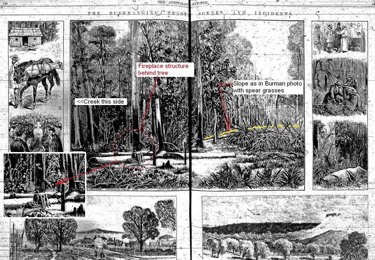
Bill,
Beechworth Committal Hearing. McIntyre statements.
Recorded by the The Age 7th August. 1880
“Sergeant Kennedy came on – from about ten or twelve yards in advance of Scanlan.”
The Mansfield courier 25th April 1908.
“Last week a historical tree known as the “Kelly” tree, Toombullup, where Sergeant Kennedy and the other police were shot, was cut down by employees of the Sawmill Company….”
Leaving the stump.
Jack Healy came to the district in 1922 and can remember seeing the stump of the white gum tree where the police were camped “where the shooting started” “You could still find bullets in the wood”
Based on the photographs and the written evidence provided by the locals that lived in the area the location of the original (first) Kelly tree can be closely established.
Where you argue against this evidence as the location of this tree does not suit your chosen site.
There were numerous huts along SBC. The ones you have identified are not located within close proximity to the first Kelly tree. So are unrelated.
Glenn
Glenn and Bill : I think its pointless basing arguments about the correctness of a site on proximity to a putative Kelly tree site, which clearly by the foregoing is still itself very much in dispute. Nobody has defined what is meant by ‘close proximity’ to the first Kelly tree, but its all relative : nobody would dispute that all those sites are in close proximity to the Kelly tree site and each other when compared, say, to Mansfield. Its therefore quite reasonable in my view to say Bills site IS in close proximity to it, as was Ian Jones site, as is the CSI site. Lets just stop arguing about that approach as its getting us nowhere.
Instead, the merits of each site should be decided on other features – if it needs to be argued at all.
The thing is, the CSI argument relies on two things a rational person couldn’t accept : that those two burls are one and the same thing, and that Burman got everything the wrong way round in his set up. Theres nothing more to argue if those two things cant be resolved.
David,
That is just a cop out. The white hill and the red hill are two separate locations.
Glenn.
A cop-out? How so Glenn?
But isnt it obvious that the argument about the Kelly tree isnt ever going to be concluded if you insist that your definition of ‘close proximity’ is the only one possible?
I hesitated to add this, but Glenn’s mention of Scanlan being 10 to 12 yards behind Kennedy is more correct than my 30- 40 yards, as I meant to write 30-40 feet. This mistake is much the same mix up as Const McIntyre made in his Memoirs 24 years after the event in 1902, where in he wrote their Police tent was pitched 70 yards from the creek, while going by on the ground evidence, he probably meant 70 feet not yards. One yard = 3 feet.
Linton Briggs was taken in by the 70 yards, locating the tent three times further from the creek at 210 feet.
Glenn, you keep hammering on about the first Kelly tree being the holy grail, but as you also mentioned Jack Healy, in 1964 did say in his report that the real site is hard to find, so it can’t have been near the current Kelly tree because that is easy to find, you them mention a white hill near the current Kelly tree’. That is why in Burman’s photo, the ‘slope’ is the red hill further up the creek’ and as Healy said “I’ll show you the spot where the killing happened, – its hard to find.”
“ tourists who come to this district would never find the place. And a misleading signpost leads them to the “Kelly Tree”
see my posting 8 May re Jack Healy
I attached image to show where the fireplace of huts as viewed from the rising road showing the mess DELWP made of slope when they knew very well it was a historic site feature.
https://ironicon.com.au/images/twohutsfromroadlevelground.jpg
Attachment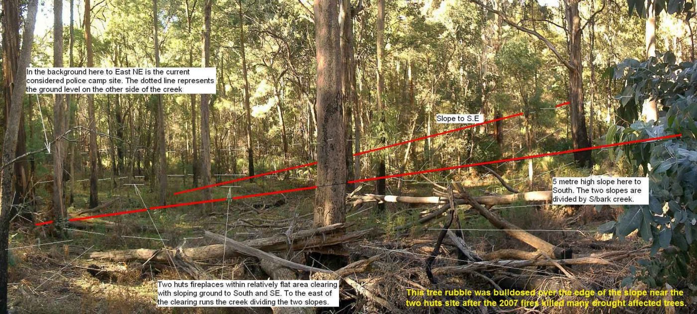
Bill, please just stop now.
Glenn
David,
“Nobody has defined what is meant by ‘close proximity’ to the first Kelly tree, but its all relative” Would you consider shots fired from say 300 yards distant as being within ‘close proximity’ of the Kelly tree? By strict definition I suppose so.
But we know from the accounts of both Kelly & McIntyre they were not.
The photos and the written evidence presented places the site on or near the white hill. Not far south of and nearby the current Kelly tree.
Back to your header remarks:“Maybe they (KTG) will withdraw their unsupported claim that local farmers perpetrated a mean hoax for generations, falsely labelling a tree as the Kelly tree so visitors wouldn’t walk on their land?” Why? Because you say they seem to be speculating, purely in order to make their theory seem more plausible.
What’s good for the goose is good for the gander.
Some of the reasoning from Bill:
“If we were to take the first Kelly tree as a most important primary source, then you must also take into account why the first Kelly tree came to be named so.” (Why I don’t know)
“Now using only primary source material closest to the event, just days after (26 Oct 1878) and in the Melbourne newspapers, the police tragedy was reported- that the police had camped near or behind the ruins of two small huts.” (Nothing about the Kelly tree here.)
“I have marked the first Kelly tree on a distance map here- “(map of his own creation) “According to McIntyre, Const Scanlan was 30-40 yards behind Sgnt Kennedy when he arriving back to camp” (When it was actually 10-12 yrds so by the sound of it his marked Kelly tree could be 20-28 yrds out)
“In 1963 Jack wrote that the current Kelly tree location was completely wrong…”
(False. No evidence presented)
“To be arguing in favour of locals who came there 50 years after the event is all very-very secondary source information and just guess work based on what they believed or were told.”
I have provided a time line of the first Kelly tree. Information provided by Bill: namely the Charlie Engelke letter and the Womans Day article. Those along with photographs supporting the evidence.
Put it altogether in a logical fashion and presented it. Stating that: …the locals have provided enough information for us all to agree on that with a high degree of certainty.
On that basis I have agreed that the KTG campsite claim is unsustainable. Contrary to what you may think I have not pushed the CSI teams conclusions. And avoided any debates about sites.
You have said:
“I think its pointless basing arguments about the correctness of a site on proximity to a putative (generally considered or reputed to be) Kelly tree site ,which clearly by the foregoing is still itself very much in dispute” “ Instead, the merits of each site should be decided on other features – if it needs to be argued at all.” Why is that a cop out?
Just look at what has been presented as evidence in response.
We are all so defensive of our sites and convictions, no matter what anyone puts forward it is argued and debated, side tracked, twisted about until the cows come home.
Even if it they may be correct. It’s a complete waste of time as we are too busy blowing our own horns.
I’ve endured 12 years of debates. Learned some very interesting things and listened to a lot of crap. At the end of the day what has been achieved?
I’m content that the current Kelly tree has been duly signposted. That’s something I suppose.
Glenn
It seems to me there are a few primary bits of importance in this debate.
The Melbourne Heralds special reporter’s story published on November 5 is the most contemporaneous and makes very substantive observations about where the police had camped, and it was at the same time that Burman was at SBC.
This is the reporters description
This was a cleared space, of about ten acres in extent, on a gentle slope, rising gradually, and on the further side having a northerly and easterly aspect. The site until recently was occupied by a prospector’s hut. A small race has been cut along the side of the hill, and the Stringy Bark Creek, for some little distance up and down from this spot, has been prospected. About six months ago the party who occupied the hut fell out, and it was burned down. One of them was tried for arson, but was acquitted. The site has been partly cleared as a paddock for a horse, but no fencing was erected. The place was an excellent one for the camping ground of a party who were not expecting to be attacked. For a party assailed by enemies, however, no worse spot could be chosen. The police tent was pitched on the northern slope of the hill and faced that direction. At the rear of the tent, the slope goes gradually up to the summit, receding again to the creek, which winds partially round it. Across the creek, at the back of the little hill, was a fallen gum-tree, over six feet high at the butt end, and behind which twenty men could find shelter. This tree can be reached from the scrub which covers the country in the direction of the King River. At the top of the slope and overlooking the police tent, was a clump of scrub and sword-grass, some sixty feet in circumference, and in which a dozen men could readily conceal themselves. Standing a few feet in front of this clump of scrub but still overlooking the police tent, are two bunches of sword-grass, four feet six inches high, and presenting a covering surface of some six feet. It was from behind these bunches of sword-grass that Kelly and his confederates called on the police to surrender. Having reached the gum-tree from the bush , the hill hid their approach to the clump of scrub mentioned, the distance being about 20 paces. At the time the call to surrender was made, M’Intyre was at the fire cooking. This was precisely 39 paces from the foremost bunches of grass. The tent stood exactly 25 paces from the Kelly’s hiding place. At the time M’Intyre was challenged his revolver was in the tent, Lonigan was coming up the eastern slope of the hill from the little creek, and when called on to surrender was close to a white-gum tree, sixty paces from the place where the bushrangers were concealed, the tree being on his left-hand side, the Kelly’s hiding place being on his right, a little to the front. Lonigan dropped his billy of water and made for the tree. Kelly, however, was too quick, and shot him dead. Having secured M’Intyre’s arms and killed Lonigan, the assassins came from their hiding places, and took up their positions behind two fallen gum trees, about two feet six inches high. The trees met at an oblique angle in front of the fire at which M’Intyre was cooking. In this crutch the Kelly gang took up their position; sitting M’Intyre on the log facing north. It was from that direction that Kennedy and Scanlan were expected. When they were heard approaching, the four men crouched down behind the gum logs mentioned, and covered the troopers as they emerged from the scrub and travelled gently up the northern slope. Scanlan was shot down within two paces of a large stringy bark tree, and had he been able to take two steps more, and reach the friendly cover of the tree, he, with the Spencer rifle which he carried, would, to a certainty, have shot down every one of the gang, as they could not move from the logs behind which they were sheltering without exposing themselves to his fire. The particulars of M’Intyre’s escape have already been made public, and there is no need to repeat them here. Kennedy evidently made off in the direction in which he had come into camp, that being the one M’Intyre had taken; in fact, it was the most natural route to choose, as a turn to the right would lead into the creek, while a rush to the left would have taken them right across the point of fire. To advance would be madness. There was, therefore, nothing for McIntyre to do but to rush straight on down the slope till he reached the scrub, and Kennedy’s only course was to turn about and follow him. When telegraphing from Mansfield a few days since, I expressed my conviction that Kennedy had wounded if not killed, one of his assailants. The former appears not to have been the case. Looking at the scrub through which Kennedy’s horse rushed with M’Intyre after he got out of the clearing, it is difficult to understand how any horse could have galloped in such country. The horse, however, was known to be a really splendid bush traveller, and the way in which he beat down the dead wattle scrub in his stride shows him to have been all he is said to be as a bush-goer. He could not have been guided, but was allowed to take his own course being urged on by M’Intyre. Close by where Kennedy fell a large white gum tree is marked by a bullet, and this is the only tree marked, showing that few shots were wasted. Coming back to where Scanlan fell, I carefully examined the ground, and found a few gum leaves thoroughly saturated with his blood. Close to the pile of logs on which M’Intyre sat while the murderers waited the coming of Kennedy, and Scanlan, I found a number of the feathers of the parrot which M’Intyre shot in the morning before the Kellys came upon him. Taking some of these and the blood-stained gum leaves as souvenirs of my visit, and leaving Mr Burman to photograph the various scenes, I struck across country to pick up a police patrol
Now match what the reporter said with the Denheld and CSI information. I have read the CSIs (yes I did purchase a copy) and it gives much credence to being aligned with the reporters description. I have found it impossible to find a cogent document with the Denheld submission.
There are other very interesting matters provided by CSI, a long section survey which points out the features described by the reporter, a summary of distances mentioned in The Age the Argus the Herald Neds Jerilderie letter and by McIntyre in his memoirs. (ALL using YARDSs except for when describing how far Lonigan was from McIntyre at the camp fire which was said to be 10 or 12 feet) and of course the very detailed layout diagram prepared by McIntyre of the camp area and the movements of the police and the gang during the shootings.
Perhaps the CSI got their burls wrong but this is not of such importance as all the other stuff presented by the CSI which seems to be spot on.
I also note the CSI offered a number of recommended actions concerning the future development of the area.
Thanks Ivehadenough for the interesting reporters story. Its something that should be read very thoroughly and along with the burman photographs is very important.
I have now read all of the reporters story from the newspaper which I got from using Trove .
In it he says that Burman was hunting about in Mansfield for help in finding the camp spot which he finally managed to do with the help of the reporter and Mr Monks. From this it would be reasonable to assume that Burman was not aided with assistance from any authority such as the police department which leads one to the conclusion that he was acting solely as an private individual and without any so called forensic intent to make photographs for the authorities to use. No doubt he was there to make saleable souvenier postcards
for profit. And in so doing my well have taken license in preparing his subject matter with people to get the best photograph he could without undue thought to total accuracy of the engagement.
I am also amused that Bill includes a photo of the englekes in one of his posts. What has this to do with anything about where the police were and where the trees were?? Perhaps it is to show that the englekes really were real people and not made up for the story??
I would like to add to ivehadenoughs recent comment about distances because apart from yards and feet being used in the reporters story there is also paces mentioned when he talks about where the police tent was that mcintyre was precicesly 39 paces from the speargrass bunches and the tent was 25 paces from the hiding place of the Kellys.
And your point is what exactly?
Aren’t you merely repeating the CSI talking points about the Burman photos?
(Which is that the only way the CSI case has any chance at all is by rubbishing Burman and claiming that when he recreated the police camp for his photos he got it all arse about face? If you are going to argue that he didn’t care about getting it right – and he certainly was given the right information – then you have rendered the photos completely useless to any argument about where the site was or what it might have looked like. Your argument means he might have taken his pictures anywhere up there or even out the back at Mansfield.
Oh my gord what a lot of Wallys. Talk about CSI saving the face.
This is what you get when total amateurs, supposedly ‘crime scene investigators’ publish their ‘belief’ hoping their written word will get traction. They are deluded.
This modern form of deception is the biggest danger to historical records.
The most primary sources concerning SBC is photographic and written material such as newspaper reports closest to the event. The reporter recorded what he saw with his own eyes only days later, he wrote that he was on a little HILL looking DOWN to where the police tent had stood -or to that effect near the northern slope of the little hill where the creek wound around – blah blah blah.
If this scenario was at the CSI@SBC ‘chosen’ location as near the current Kelly tree, THERE is nowhere there, you can be looking down from a little hill, as its all flat except for a gentle 4 degree fall east to the creek.
I say, come on you pretending ‘crime scene investigators’, your documents are laughable. Just stop trying to push this rubbish.
Its laughable the CSI fellas have never provided a Burman photo comparable, and they don’t even recognize the slope in the photo, they don’t have two huts evidence as per fireplaces of huts, and they gloss over the Nov 1878 reporters descriptions of the place, and David, all they want is the last word on the subject on your page. Glenn asked me to stop and I did, but they don’t want to because its too embarrassing for them unless they have the last word.
I would like someone to explain what the Burman photograph gives us I believe that the returning two policemen Sergeant Kennedy and Constable Scanlan approached their camp coming to it from a northerly direction and that when they did so that Constable McIntyre left his position near the camp fire and walked towards Sergeant Kennedy and he also got hold of Kennedys horse on which he then made his escape.
If I am correct in saying the police came from the north and the man standing in the photograph was placed there to be Segeant Kennedy then the direction of the photograph is towards the north west. And to be accurate there should have been a horse near him which would have been the one taken by constable Mcintyre and it is totally wrong to show the two men acting as Ned and constable mcintyre so close together. using the four points where mcintyre says he was in his diagram then they were never so close together . If I am right then this photograph is not doing a very good job of accuracy. Is this right?
Thanks
Given the constraints on the way in which photography was carried out in 1878, the Burman photos are an excellent record of the actual scene. However, when preparing to take the picture, if the ‘Kennedy” figure on horseback had been placed exactly where it was thought he really was at the time of the confrontation he would have been a long way out on the right hand side, and unseen, so to get him into the shot Burman moved him in closer. Alternatively he could have moved his camera a lot further back but then all figures would have been tiny in the distance and probably obscured by the intervening bush. But in general I believe the photo captures the fundamentals of the relationships between the various parties accurately.
One other thing – given that the photo shows the northern side of the east-west log, the orientation had to be southwest not northwest.
Anoymouse asks why the Burman photo East West log is showing the northern side? Answer: Simple because the main midday light representing the sun is ALWAY from North in the southern hemisphere. The photo shows all objects in the photo lit up from behind the photographers right shoulder- suggesting early mid afternoon.
The attached image shows Burman’s photo East West log lit up from behind the photographer because also, notice there are no shadows on the trees, they are lit face on generally from the right being North west. Mc said he sat on the north side of the log looking north down the creek and the sun set to his left.
Attachment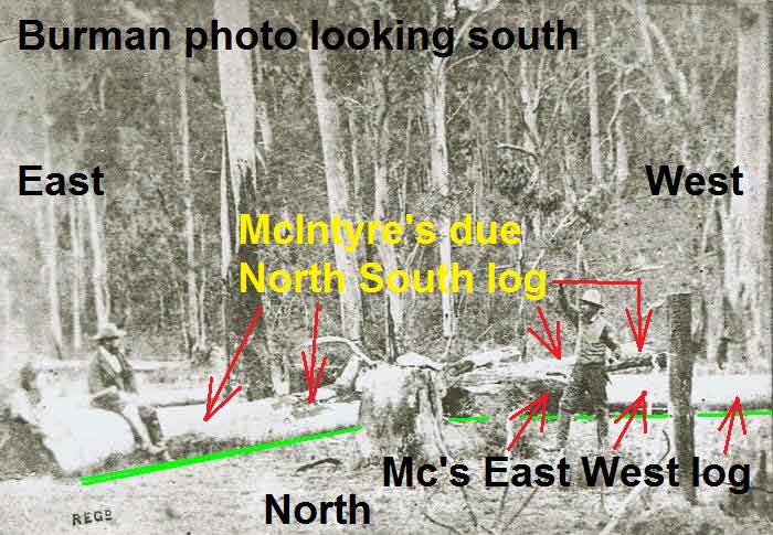
Thanks David How do you know that the the photo shows the the northern side of the east west log? and why do you say the photograph shows the fundamentals of the relationships between the various parties. It does not as I said in my first question. Ned and McIntyre never were as close together as the two men in the photograph.
I therefore would say that the photograph does not represent an historical factual event but merely gives a photograph of the countryside. I wonder if this is why its only use at Neds hearing was to show what the countryside looked like. Earlier someone said it was not forensic and I guess thats pretty right if it does not put the various parties in positions of being correct?
No, sorry anonymous its NOT ‘about right’ to say the Burman photo was just to show the country side and isnt ‘forensic’. As Ive already explained, the constraints of the techniques of taking photos in the bush in 1878 necessitated that the exact places in which persons once stood couldn’t be replicated but the relationships between the parties certainly could be. And thats what Burman quite obviously did do. McIntyre is to Kellys left, Kelly is behind the log, and they are both looking toward the arriving policeman coming into the clearing from the north. and as Bill has shown, the shadows confirm this interpretation to be correct.
I will show another picture which will help Anony understand why the photographer could not take a WIDE panorama shot with his 3×4 ratio camera. He had to compress the relevant people into his photo, but I had many years ago already made this image to answer such questions. I do not believe Glenn or any other CSI@SBC site believer could be so ignorant of basic photo representation, so please see the attached. Notice Ned has been moved to where he sat near the fire, and McIntyre is now sitting on the East West log with Sgnt Kennedy coming from the north, but – he is north westerly, so if he was coming from the north the photographer would only see his back. -hence Kennedy is seen to the west in order to show his side view with arm up.
Please see and study the attached, it will help you orientate the scene.
Attachment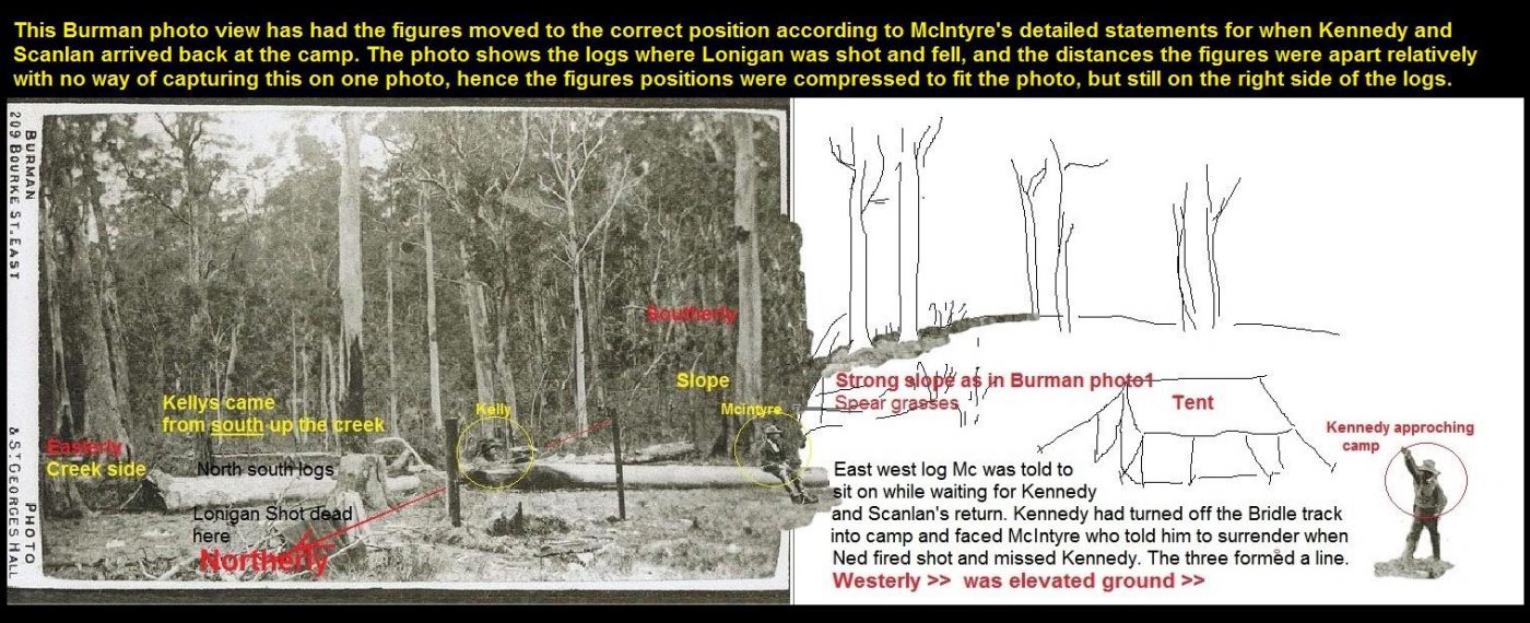
I guess I am an ignorant person when it comes to photography. Bill says Ned was moved to where he sat near the fire. Im sorry but if the fire was in the place where the two large logs crossed then in the Burman photograph Ned is as far away from the fire as he could be hes at the end of the log on which Mcintyre is sitting. Mcintyre in his drawing shows ned did not move from this position until I suppose he had to go after Sergeant Kennedy.
I am also worried about the burl tree to which there has been much derision aimed by David.
If you look at the CSI analysed photograph the burl tree is given a label of K2 and it has two distinct markings. There is a burl high up on the tree trunk and at its base is another very clear marking which is viewable in both the two photos by Burman and also clearly visible in the other photograph that the CSI team has provided called the beautiful mansfield booklet photographs.
I will say it again as neither you nor bill can accept that the Burman photographs are not giving an accurate display of the three people concerned being ned mcintyre and kennedy.
The photographs represent a lie made up by bBurman for his own interest in turning a shilling or two by selling his photos.
“The photographs represent a lie made up by Burman for his own interest in turning a shilling or two by selling his photos” Oh really? You know that do you? Youre saying to make a few shillings, and having no interest in accuracy or the historical record he dragged all his equipment up through the bush to recreate something he could have very easily done out the back of the studio in Mansfield? According to you then, in addition to being a liar Burman had to have been a complete idiot.
What Ive observed is that when kelly nut jobs like you are losing the rational debate and have run out of ideas you always resort to hysterically stupid conspiracy theories like this one, and outright denial of the bleeding obvious. But hey its a free world Anonymous, and nothing stopping you believing whatever garbage you like – and let me guess : the election was stolen??
Anonymous what you are missing is that Burman took a photo of the place where it happened as McIntyre said it was the place shown. And he positioned the actors as indicative but needed to place them so they could all fit into the picture. So you are making a silly case that because the actors are not placed with exact historical precision the photo location itself must be wrong. That’s ridiculous.
David, You are now showing your true colours with the twaddle you write.
What studio in Mansfield do you refer to? Burman was based in Melbourne.
And getalife you too dont know what you are talking about.
Yes he was just being a very entrepenual commercial photographer. Clearly he wasnt a Mansfield person as he had to seek out people who could get him out to the camp site.
I have never said that the place shown in his two photographs was wrong but I have said that he placed his three actors where they would give him the best photo op. So the only relevant use of his two photos is for the layout of the logs and the immediate background.
So as to the background its most salient feature to assist us is the tree in the right of his photos. This tree displays two markings one at its base and importantly one probably around 15 feet up its trunk, a burl. Then in around 1897 three men are photographed at the site and there plainly for us all to see is that same burl tree. A sentinel that is indisputable.
The other interesting thing about this 1897 photograph is that it shows or rather doesnt show much of a rise in the immediate background but far in the distance what is very clearly a hill.
We note that the csi team have also identified this hill and they say that it is approx 20 degrees north of east from the campsite. So this sentinel tree is a very important clue to the direction in which Burman pointed his camera to make his photos. Ill let you work that out.
As the Burman photos show this tree front on then it can be adduced that his camera position would have been somewhere to the left, out of image, of the 1897 photo which by the way the csi team also point out that the remains of two logs can be discerned in the photo with the ns one in the photos foreground and the ew one lying with its east end pointing to the bas of the sentinel tree . This is also clearly obvious in Burmans photos.
And in the 1897 photo there are no piles of rocks visible.
Heres the photograph which appeared in the Beautiful Mansfield booklet of 1906
Attachment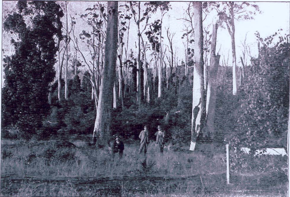
I stand corrected. But of course, if he came all that way from Melbourne it makes your claim that it was all about commercial gain even more absurd, if getting it as right as he could wasn’t of any interest to him. If it was dumb to come from Mansfield to make ‘a lie’ it was hysterically stupid beyond belief to come from Melbourne to do it. So now to swallow the CSI team report you have to also swallow the claim that Burman was the most stupid photographer in the Southern Hemisphere.
The most sensible and rational view of what Burman did will always be that he went to all that trouble because his interest was in making images that recreated as accurately as possible what really happened. My view on that will never change.
And thanks for the Mansfield photo – nice pic, but seen it many times before.
As for the rest of your post, youre just going over all the csi talking points, and they’ve been dealt with long ago, just like all the arguments about the earth being flat have been. Rant away as long as you want….but spare us the bull about the election being stolen.
If a posting is anonymous I always wonder why hide your identity.
All I can suggest to readers here, this sort of argi bargy started 12 years ago when I selected a small group of seemingly rational minds to solve the numerous SBC site discrepancies left to readers of Ned Kelly book author Ian Jones.
I proved his chosen East bank site wrong even though he could see the Burman photo slope from the east bank. Finding the two huts fireplaces left Ian Jones speechless – to me on the phone.
It was I that identified the hill in the Mansfield photo that proved to the group the Burman photo was not taken there. And besides, it was taken 18 years after the event when a new generation of people moved into the area, but, by this time the true site had become obscure, and extremely likely NOBODY local had ever seen the Burman photos and site. If they had they would not have published the Beautiful Mansfield photos looking in the wrong direction.
All I can say – this re gurgitation of seriously false observations by those with a vested interests – like burls on gum trees compared to Burman photos nobody local would have ever seen, and if they had, they would not have agreed to the Beautiful Mansfield brochure photos.
The true site was already by then faded into obscurity away up the creek just outside the land allotment boundaries.
Bill.
David, your inability to grasp anything outside your own theory is demonstrable! As already pointed out to you, Burman was not taking a forensic photo of a crime scene, he was taking a photo of where events happened. He would have picked the best position for his camera, that best displayed the area. Burman was a successful entrepreneur in fledgling industry and would have known more about photography and how to make a shilling out of it than you! As hard as that may be for you to swallow, ignorance does not an argument make! When the photo was produced at trial, McIntyre said the photo depicted the area, he DID NOT state anything about the actors in it. There are none so blind as those that refuse to see.
Signed, Only the Facts.
And what are you suggesting we are supposed to deduce from the fact that McIntyre said nothing about the actors in the photo? Are you going to put words in his mouth? That would be typical of mad kelly conspiracy theorists like yourself, just making stuff up where you need something to support your failed argument, but the reality is this : NOTHING can be deduced from something someone didn’t say.So lets not waste any more time on THAT dead end.
I need also to point out to you that my view of the orientation of the Burman photo is not just based on the logical argument that Burman wouldn’t have gone to all the trouble and expense of dragging himself and all his gear up to the wombats just to create a fake image, what youve called ‘a lie’. Your belief that he went to all that trouble to create a wrong image, a ‘lie’, when he could have just as easily created an accurate image, the ‘truth’ is laughable stupidity. For you to suggest an entrepreneur photographer would risk being exposed as making ‘fake’ pictures – what you call ‘lies’ – when just as easily he could make them as near to the truth as the medium would allow is again laughable stupidity. The blindness is yours mate!
But my view and the view of most others about the orientation of the photos is also based on the interpretation of where sunlight and shadows are seen in the images, these in turn indicating where north and south are. Those two independent approaches match perfectly.
Rant on if you must but you’re going nowhere other than exposing yourself as delusional fanatic.
We now butt in with our observations.
The burl tree which clearly appears in both the Burman and Mansfield photographs is the same tree. Burls are like skin birthmarks on people. Once there then its for life. The Mansfield photo is taken looking in a easterly direction. Remnants of the two logs can be seen in it also.
The rubbish about people not knowing where the place was is ridiculous. In the intervening years between 1878 (Burman) and 1897 (Mansfield)there would have been undoubtedly locals including those from the nearest main town of Mansfield who would have visited an easily found place where two rather large logs lay in particular.
So this burl tree displays itself in both photographs clearly photographed with a camera shot looking to the east.
And as anon has rightly pointed out earlier the two actors close together do not represent anything like the historical truth of where they were placed when Kennedy approached the camp site after having dismounted from his horse. As we now he was approaching from the north.
Then this would mean the burl tree would have to have been to his left.
It clearly is not so in the Burman photos being on his right hand side.
This leads to the obvious conclusion that he too is inaccurately portrayed by Burman and in fact the two actors are indeed facing south and for the purpose of Burman he too – Kennedy is approaching the two actors from a southerly direction thus placing the burl tree to his right hand side.
The Mansfield photograph is also very telling in that there is a slight rise shown covered in vegetation behind the three men shown and this degree of rise is consistent with the contour maps of the district. The Heritage Victoria diagram 2205 VHR H2205 used for the Heritage listing afforded to the Stringybark Creek site shows a contour gradient of 20 metres and for the area including the claimed possible sites of Bill and CSI rising from 770 to 800 metres looking east along SBC road for 400 metres. The source used for this depiction is the 1:25000 map series* This gives an indicative height rise of around 20 to 30 metres for the background of both the Burman and Mansfield photographs.
IF there is someone who has the skill to erase the erronous placed figures of Ned McIntyre and Kennedy from the Burman photo then we would have an unadulterated photo of the site which would remove any ambiguity of direction.
Re Burman we quote from Wikipedia “Australian commercial photographer”
His place of business is clearly shown on the Carte de Visite at
https://victoriancollections.net.au/items/52953bd42162ef19305836d3
Burman & Madeley also used this photograph as one of the cards in a set which they sold to the public.
* Also from Vicmap is the 1:50000 series issued by DSE in 2008 and is obtainable by ordering it as the Whitfield 8124-S print.
So ‘NEFC’ and ‘Anonymous’ and ‘Ivehadenough’ – I am interested to know what is the purpose of your Anonymity? Youre clearly all singing from the same song sheet, the pseudoscience of the CSI group. Is there any reason you need to be anonymous? ( Apart from not wanting to be identified as nut jobs that is)
But NEFC I really have to wonder what the HELL you are on about. Did you see the clip of the lunatic who said the Vaccine was magnetising everyone because it had metal in it, and she went on to prove it by holding a key to her neck – and it straight away fell off! She didnt seem to think the failure of her proof actually meant she was wrong. I was reminded of this when NEFC claimed the burls are like birth marks and prove those two trees are the same tree – except for the fact that the burls are completely different shapes from each other! Hello??? Your ‘proof’ is a complete failure. Theres no point in you lot carrying on with this rubbish. Just make up yourselves a little Facebook secret members-only group and go there and talk to each other about your delusions. You’ll be happier there I am sure than you will ever be coming here to post your silliness.
Seems the only way to end these dysfunctional forum type discussions is for on site show and tell by each site advocate group.
I therefore advance the proposition that each stake holder prepare a printed leaflet putting their case to be handed out to all onsite attendees.
We could call the meeting; ‘The October SBC Symposium’ to be overseen by DELWP and Heritage Victoria in conjunction with Latrobe University and the Australian Archaeology Association members. AAA.
Nice idea Bill !
Actually Bill, now that HV and DELWP have taken it upon themselves to commit the time and funding to evaluate the KTG claim , I am wondering what grounds they would have for not offering the same respect to the claims made by others about potential historical sites up there? I would like to know why they decided to give that claim preferential treatment, and on what basis having now set a precedent for claims about SBC they could refuse to evaluate other claims in a similar way? Do you have to be ‘in the know’ or in some other way have connections that can pull the stings for you behind the scenes?
It might make an interesting topic for a motivated journalist to investigate the possibility of some sort of favouritism in the ranks of Heritage Victoria if you asked HV to investigate your claim in the same way as they did the KTG, and then they refused? The CSI mob could make the same request and also expect equal treatment.
I would love to make a submission to some sort of independent assessor, and begin by saying the place to start is the Burman photos, and the first thing to decide is what is their orientation! Imagine if ‘Ivehadenough’ and NEFC turned up and tried to persuade them that Burman photo was ‘a lie” and he had all his ‘actors’ looking the wrong way! This assessment would result in CSI and Adam Ford getting knocked out of the ring in the first round!!
You seem to miss the point raised by Ivehadenough and NEFC . They raise questions that you and Bill duck and do not address. You two must have been to pollies school to so artfully but crudely dodge the questions. If I have understood the questions right then they deserve to be answered civilly. I agree that the Burman photographs are a lie in my opinion. They show the country OK but do not accurately show the men included for the purpose of illustrating the early part of the entrapment of the returning sergeant of police to his camp.
The matter of that burl tree throws a greet big spanner into the discussion as to the location of where the police were. With the passing of time burls change but they remain in the same place on the tree forever and relative distance to the trees base as it grows. This tree unlike the teapot tree is giving us the opportunity of a perfect comparison between the terrain of the Burman and the Beautiful Mansfield photographs. And so far there has not been any sort of rebuttal to the questions asked by the incognito correspondents referred to. My money is on the BM photograph as being the one which gives the lie to the Bill claim. I too will remain in the anon mob
Oh so are you yet another ‘Anon’ or just the same “Anon’ we have already encountered? It gets confusing.
Thanks for at least agreeing that the two ‘burls’ dont resemble each other, but how you can claim two non-identical burls identify the same tree in two different photos beats me! Every second or third tree has a burl on it!
I am telling you claiming non-identical burls prove the two trees they are on must be the same tree is a laughable bit of stupidity that no serious researcher would hesitate to instantly dismiss. And equally as quickly they would dismiss your stupid idea that the photos are taking looking north east when the shadows clearly demonstrate otherwise. No wonder you all want to remain anonymous!
So what was your question again?
Hello all Anonymous’s, regarding your views on the Burman photo police camp not being a reliable primary source is typical of a face saving pollyschool tactic. Just as Anons hid their identity tells readers they are not serious.
For example in their CSI@SBC short run publication of 2010 and later 2017 – they actually have a Solar Sun angle chart that shows the suns position and sunray angles during the day from east – north – west –as we know actually happens in the southern hemisphere. Yes it actually does.
These same CSI-anons reckon the Burman photo was taken facing into the sun and is a ridiculous suggestion given the front on light in the photo is hitting all the trees and logs face on, in other words few side shadows indicates the photo was taken looking southerly. You don’t need to be a genius to figure that out.
At Ned Kelly’s trial, Burman testified the “photo produced is a picture of the ground where Const Lonigan and Scanlan were shot” certainly Lonigan while the exact place for Scanlan was still slightly behind the photographers tripod, but is the general location for where the two police were shot.
At court, Burman under oath declared “ I took the photo myself” so together with McIntyre’s testimony and his sketch, they acknowledge the photos actually show the place where Lonigan fell- near that central stump with the remains of a hut fireplace and slope in the background. Even Ned himself on trial wanted to use the Burman postcard to show from where they entered the camp and no ambush – as Mc showed in his sketch from the south, and Ned wanted to show the magistrate the area ‘from alongside that slope right of photo.
The CSI don’t want this info in their book because they don’t have a slope and no creek on the left of their site, nor any evidence of two huts.
But if these CSI-anons reckon Lonigan fell dead on the other side of those logs- why would Burman who was guided by Ed Monk who was guided by McIntyre take a photo of – from behind the actual scene, and place his re enactors on the wrong side of those logs with Mc facing southerly, while waiting for the returning police ‘Kennedy and Scanlan coming from the north. These are just silly arguments by Anoyanons who are thinking like Pollies pushing their BS because they know if they can create doubt, they are left off the hook.
This is why I proposed a ‘SBC Symposium in October’, and welcome anyone with an alternative view to register their claim – including the KTG group. Stay tuned for announcements.
In the mean time please enjoy reading this their CSI report-
and my critique
https://ironicon.com.au/csi@sbc_bills_comments.pdf
and also
https://ironicon.com.au/stringybarkckinvestigation.htm
Bill the CSI supporters will NEVER change thier minds but its important that you keep posting the refutations of their arguments and the proofs of your own site so that everyone else can read them and understand the logic of your case and the illogic of theirs.
SO are you progressing this idea of a Symposium ? That sounds very exciting – can I suggest that instead of a free-for-all ranging over everything at once that you have discussions on particular components of the arguments, and please make the first topic for discussion “Interpretation of th Burman Photographs”
The photograph out of the Beautiful Mansfield booklet is as important as the Burman ones so the first topic of discussion should be expanded to also include an analysis of this photo and then its relative importance vis-a-vis the background of the Burman photos and how the photos do or dont agree with each other..
I think that what is being suggested by anons is the mansfield booklet photograph is taken with the camera pointing to a north easterly direction and if this is so then the sun in early afternoon would light up the north east side of the tree and bushes. Something else experienced bushmen will tell you is that the side of a tree which generally receives little sunlight is where the bark often will have moss on it.
You totally miss the point being made by anon about burls. Every second or third tree does not have burls on them. In fact very few do have burls.
Opinions vary as to the causes of burls but most experts agree on several factors, the first being disease. Although burl formation has not yet been fully analysed it seems able to be attributed to several diseases caused by bacteria, fungi or viruses with mould infestations being held as the most common cause. Infections just below the tree bark seem to trigger these abnormal growths with the tree’s cells continuing to grow at the same rate as the rest of the tree but in a drastically changed direction.
Environmental stress and physical trauma also contribute to burl formation. The former can include a response to injuries from fire or flood or to irritation from constant wind or water erosion. Physical trauma can include insect damage, wounds from animals or injuries from logging. In many cases it will be a combination of factors that will cause burl growth and basically anything that can injure a tree has the potential to cause it.
Burls grow just as the host tree does. But they will always be in the same position on the tree as it ages and just as a tree alters its form over the growth years so does the burl but it remains in the same position on the tree.
Hers a pretty good description of how a burl grows by Bill Grundmann.
A burl is made up of a tree’s bud tissue that has not sprouted into foliage or grown into a twig. It has a woody or barked surface. As a burl grows, it incorporates the tree’s undeveloped buds that surround it and folds them into its expanding form. Because these cells can grow faster than regular tree cells and can grow during all seasons, burls expand at their own rate into unpredictable sizes and appearances.
A bushman you aint David. Stick to your day job if you have one otherwise take an arborist course so you can rant about burls of which you seem quite ignorant with your comments so far.
Its about as good as telling us that Burman had a studio in Mansfield.
Once the Burman photo has been analysed, it will be obvious that the only explanation that logically accounts for both the position of the ‘actors’ and the surfaces on which light and shadow are seen will be that the camera faces to the south or south west. This will then mean that the two photographs of trees with burls on them cant possibly be two photos years apart of the same tree because the Beautiful Mansfield Tree photo was taken looking to the north west, and as Brain Boy has so kindly informed us burls never change their position on a tree. Therefore no discussion of the BM photo will be required as it is irrelevant.
This discussion doesnt require botanical knowledge : it requires logic and reason, which Bonehead boy is deficient of.
Hello. You havent put up my reply. I want five tickets to the symposium
You havent submitted one. If you had I would, though I predict it will be another fizzer.
Bonehead and Brain Boy,
You won’t need any tickets as you 5 will be a SBC stakeholder putting your case, so get working on it. Just make sure you get your Burman photo orientation right.